geo.wikisort.org - Isola
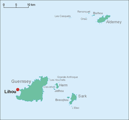
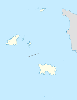
Lihou è un piccolo isolotto disabitato di circa 15.6 ettari a ovest della costa di Guernsey, ed è il punto più occidentale delle Isole del Canale. Collegata all'isola maggiore da una lingua di sabbia, fa parte della parrocchia di St Peter's
| Lihou | |
|---|---|
 | |
| Geografia fisica | |
| Coordinate | 49°27′40″N 2°40′03″W |
| Geografia politica | |
| Stato | |
| Cartografia | |
 Lihou | |
| voci di isole del Regno Unito presenti su Wikipedia | |
Si tratta di un'importante riserva naturale per la fauna marina.
Sull'isola si trovano le rovine del priorato di St. Mary, che si dice fondato dai Benedettini nel XII secolo, fino al 1415 sotto il controllo dell'abbazia del Mont-Saint-Michel, per poi passare sotto l'Eaton College fino alla riforma, per poi cadere in rovina.
L'unica casa di Lihou fu utilizzata come bersaglio per l'artiglieria pesante durante la Seconda guerra mondiale dai tedeschi e oggi, ricostruita, ospita un centro informativo.
Altri progetti
 Wikimedia Commons contiene immagini o altri file su Lihou
Collegamenti esterni
- Sito ufficiale, su lihouisland.com.
На других языках
[de] Lihou
Lihou, nicht zu verwechseln mit dem australischen Meeresschutzgebiet Lihou Reef, ist mit knapp 16 Hektar die kleinste zumindest zeitweise bewohnte Kanalinsel und liegt etwa 500 Meter westlich von Guernsey. Die Gezeiteninsel (englisch Tidal Island) ist bei Ebbe über einen befestigten Damm vom Fort Saumarez aus zu erreichen. Wegen der starken Gezeitenunterschiede ist die Größe der maximal etwa 400 × 300 Meter messenden Insel nur schwer zu bestimmen, da bei Ebbe weite Teile der Küste trocken liegen.[en] Lihou
Lihou (/ˈliːuː/) is a small tidal island located just off the west coast of the island of Guernsey, in the English Channel, between Great Britain and France. Administratively, Lihou forms part of the Parish of St. Peter's in the Bailiwick of Guernsey,[1] and is now owned by the parliament of Guernsey (the States of Guernsey), although there have been a number of owners in the past.[4] Since 2006, the island has been jointly managed by the Guernsey Environment Department and the Lihou Charitable Trust. In the past the island was used by locals for the collection of seaweed for use as a fertiliser, but today Lihou is mainly used for tourism, including school trips. Lihou is also an important centre for conservation, forming part of a Ramsar wetland site for the preservation of rare birds and plants as well as historic ruins of a priory and a farmhouse.[es] Lihou
Lihou[1][2] /'li.u/ es una pequeña isla de unas 15 hectáreas de superficie (0,15 kilómetros cuadrados), forma parte de las Islas del Canal. [3]Se encuentra al oeste de la costa de Guernsey y constituye el punto más occidental de las Islas del Canal. La isla forma parte del bailiazgo de Guernsey desde enero de 1995.[4][fr] Lihou
Lihou est une des îles Anglo-Normandes. Elle est située à l’ouest de Guernesey, à laquelle elle est reliée lors des marées basses de printemps. Elle a une superficie de 20 hectares, pour une longueur de 500 mètres. Lihou fait partie de la paroisse de Saint-Pierre-du-Bois.- [it] Lihou
[ru] Лиху
Лиху (фр. Lihou) — остров (38,5 акров, 15,6 гектаров) в проливе Ла-Манш в составе Нормандских островов к западу от острова Гернси, коронного владения Великобритании Гернси.Текст в блоке "Читать" взят с сайта "Википедия" и доступен по лицензии Creative Commons Attribution-ShareAlike; в отдельных случаях могут действовать дополнительные условия.
Другой контент может иметь иную лицензию. Перед использованием материалов сайта WikiSort.org внимательно изучите правила лицензирования конкретных элементов наполнения сайта.
Другой контент может иметь иную лицензию. Перед использованием материалов сайта WikiSort.org внимательно изучите правила лицензирования конкретных элементов наполнения сайта.
2019-2026
WikiSort.org - проект по пересортировке и дополнению контента Википедии
WikiSort.org - проект по пересортировке и дополнению контента Википедии