geo.wikisort.org - Isola
Le Isole Andreanof (Niiĝuĝin tanangis[2] in aleutino) sono un sottogruppo delle isole Aleutine a sud-ovest dell'Alaska (Stati Uniti).
| Isole Andreanof | |
|---|---|
 | |
| Geografia fisica | |
| Localizzazione | Mare di Bering (Oceano Pacifico) |
| Coordinate | 51°52′22″N 176°11′44″W |
| Arcipelago | Isole Aleutine |
| Superficie | 3.924,737 km² |
| Altitudine massima | Tanaga (1.806) m s.l.m. |
| Geografia politica | |
| Stato | |
| Stato federato | Alaska |
| Demografia | |
| Abitanti | 412 (2000) |
| Cartografia | |
 Isole Andreanof | |
| voci di isole degli Stati Uniti d'America presenti su Wikipedia | |
Geografia
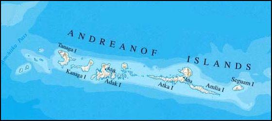
Le isole Andreanof si trovano tra lo stretto di Amchitka e le isole Rat ad ovest, e lo stretto di Amukta e il gruppo delle isole Four Mountains ad est, a circa 52° Nord e tra 172°57' e 179°09' Ovest. Le isole hanno un'area totale di 3.924 km² e si estendono in lunghezza per circa 440 km².
Le più grandi fra le isole Andreanof sono, da ovest ad est:
Ci sono inoltre altre piccole isole: Isole Amtagis, Aziak, Bobrof, Isole Channel, Chugul, Egg, Green, Igitkin, Kasatochi, Koniuji, Little Tanaga, Oglodak, Sadatanak, Sagchudak, Tagalak, Umak e Isole Vasilief. Le isole Delarof poi costituiscono la parte più occidentale dell'arcipelago delle Andreanof.
Le isole sono di solito nebbiose e sono prive di alberi a causa del vento quasi costante e sono particolarmente soggette a terremoti, che spesso si verificano quotidianamente con una magnitudo superiore a 3; il terremoto di maggiore intensità risale al 1957 (magnitudo 8,6)[3][4]. Più recentemente, il terremoto del 2007 ha raggiunto magnitudo 7,2[5].
Storia
Hanno avuto il loro nome dal navigatore russo Andrejan Tolstych, che fu il primo ad esplorarle nel 1761.
Ci sono stati diverse basi militari degli Stati Uniti sulle isole durante la Seconda guerra mondiale; le basi su Adak furono ampliate e rese permanenti dopo la guerra, ma sono state chiuse nel 1995.
Popolazione
La popolazione totale ammontava, al censimento del 2000, a 412 abitanti[1], la maggioranza dei quali vive nella città di Adak sull'isola omonima.
Note
- U:S: Census Bureau - Andreanof Islands: Blocks 1083 thru 1137, Census Tract 1, Aleutians West Census Area, Alaska Archiviato l'11 febbraio 2020 in Archive.is.
- Bergsland, K. (1994). Aleut Dictionary. Fairbanks: Alaska Native Language Center.
- Largest Earthquakes in the United States, su earthquake.usgs.gov. URL consultato il 30 gennaio 2011 (archiviato dall'url originale l'8 giugno 2011).
- Historic Earthquakes - Andreanof Islands, Alaska 1957 03 09 14:22:31 UTC Magnitude 8.6, su earthquake.usgs.gov. URL consultato il 18 luglio 2013 (archiviato dall'url originale il 31 luglio 2013).
- Magnitude 7.2 - ANDREANOF ISLANDS, ALEUTIAN IS., ALASKA 2007 December 19 09:30:30 UTC, su earthquake.usgs.gov. URL consultato il 9 agosto 2013 (archiviato dall'url originale il 18 dicembre 2009).
Voci correlate
Altri progetti
 Wikimedia Commons contiene immagini o altri file su Isole Andreanof
Collegamenti esterni
- Andreanof, ìsole-, su sapere.it, De Agostini.
- (EN) Isole Andreanof, su Enciclopedia Britannica, Encyclopædia Britannica, Inc.
- (EN) Isole Andreanof, su Geographic Names Information System, USGS.
- Geology of the Delarof and Westernmost Andreanof Islands Aleutian Islands, Alaska (1959) http://www.dggs.dnr.state.ak.us/webpubs/usgs/b/text/b1028i.PDF[collegamento interrotto]
| Controllo di autorità | VIAF (EN) 315527464 · LCCN (EN) sh91002082 · J9U (EN, HE) 987007553703605171 |
|---|
На других языках
[de] Andreanof Islands
Die Andreanof Islands sind eine Inselgruppe der Aleuten im Südwesten Alaskas (USA). Sie liegen zwischen den Rat Islands im Westen und den Islands of Four Mountains im Osten. Auf den Inseln kommt es häufiger zu Erdbeben mit einer Stärke bis über 5 auf der Richterskala.[en] Andreanof Islands
The Andreanof Islands (Aleut: Niiĝuĝim tanangis,[1] Russian: Андреяновские острова) are a group of islands in the Aleutian Islands in southwestern Alaska. They are located at about 52° North and 172°57' to 179°09' West.[es] Islas Andreanof
Las islas Andreanof constituyen un grupo de islas en el archipiélago de las islas Aleutianas, al suroeste de Alaska, EE. UU. Se encuentran localizadas entre el canal de Amchitka y el grupo de las islas Rata, al oeste, y el canal de Amukta y el grupo de las islas de los Cuatro Volcanes, al este. La cadena de islas se extiende unos 440 km, y ocupan una superficie total de 3.924,737 km². La población total era de 412 personas en el censo de 2000, la mayoría de las cuales habitaba en la ciudad de Adak, en la isla Adak.[fr] Îles Andreanof
Les îles Andreanof (en aléoute : Niiĝuĝin tanangis) forment un groupe d'îles des îles Aléoutiennes au sud-ouest de l'Alaska. Elle s'étendent sur environ 440 kilomètres et furent nommées ainsi par le navigateur russe Andreïan Tolstykh, qui fut le premier à les explorer en 1761.- [it] Isole Andreanof
[ru] Андреяновские острова
Андреяновские острова (англ. Andreanof Islands, алеут. Niiĝuĝin tanangis[1]) — группа островов в Алеутском архипелаге, расположены между проливом Амчитка и Крысьими островами с запада и проливом Амукта и Четырёхсопочными островами с востока, со средними координатами 52° с. ш. и от 179°09' до 172°57' з. д.Другой контент может иметь иную лицензию. Перед использованием материалов сайта WikiSort.org внимательно изучите правила лицензирования конкретных элементов наполнения сайта.
WikiSort.org - проект по пересортировке и дополнению контента Википедии