geo.wikisort.org - Isola
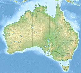
L'isola di Dirk Hartog si trova al largo della costa di Gascoyne, nella Shark Bay (baia degli squali) nello Stato dell'Australia Occidentale.
| Isola di Dirk Hartog | |
|---|---|
| Geografia fisica | |
| Localizzazione | Shark Bay |
| Coordinate | 25°50′S 113°05′E |
| Superficie | 620 km² |
| Dimensioni | 80 × 15 km |
| Geografia politica | |
| Stato | |
| Stato federato | |
| Cartografia | |
| voci di isole dell'Australia presenti su Wikipedia | |
Geografia e ambiente
L'isola è lunga circa 80 km e larga dai 3 ai 15 km per una superficie totale di 620 km² il che la rende l'isola più grande (esclusa la Tasmania) e più a ovest dell'Australia; è situata a circa 850 km a nord di Perth.
L'isola di Dirk Hartog consiste prevalentemente di dune sabbiose ricoperte dalla macchia ed è stata usata più volte come un "grosso allevamento" di pecore arrivando ad averne 20.000. Negli ultimi anni comunque questo numero è stato diminuito per ragioni ambientali.
L'isola, come la baia in cui si trova, fa parte del Shark Bay Marine Park che è uno dei patrimoni dell'umanità. Parte dell'isola è affittata alla famiglia Wardle che la gestisce come meta di ecoturismo; la regione è usata inoltre ampiamente per la pesca sportiva.
L'isola è anche un importante sito per la riproduzione delle tartarughe comuni; oltre a questa specie si riproduce nelle spiagge dell'isola anche la tartaruga verde. Esiste inoltre una sottospecie di uccello endemica dell'isola: il Malurus leucopterus.
Storia
L'isola fu scoperta il 25 ottobre 1616 dal capitano di mare Dirk Hartog che era finito fuori rotta mentre navigava con la sua nave Eendracht da Città del Capo a Batavia (ora Giacarta).
Voci correlate
- Dirk Hartog
Collegamenti esterni
- Sito principale dell'isola, su dirkhartogisland.com.
- environment.gov.au, http://environment.gov.au/heritage/places/national/cape-inscription/information.html.
- theage.com.au, https://web.archive.org/web/20121103043833/http://www.theage.com.au/travel/travel-factsheet/cape-inscription--culture-and-history-20081117-68j1.html. URL consultato il 15 maggio 2011 (archiviato dall'url originale il 3 novembre 2012).
| Controllo di autorità | VIAF (EN) 315529647 |
|---|
На других языках
[de] Dirk Hartog Island
Dirk Hartog Island (in der Sprache der lokalen Aborigines Wirruwana[1] genannt) ist eine Insel im Gebiet der Shark Bay an der Westküste Australiens.[en] Dirk Hartog Island
Dirk Hartog Island is an island off the Gascoyne coast of Western Australia, within the Shark Bay World Heritage Area. It is about 80 kilometres (50 miles) long and between 3 and 15 kilometres (1.9 and 9.3 miles) wide and is Western Australia's largest and most western island. It covers an area of 620 square kilometres (240 square miles) and is approximately 850 kilometres (530 miles) north of Perth. It was named after Dirk Hartog, a Dutch sea captain, who first encountered the Western Australian coastline close to the 26th parallel south latitude, which runs through the island. After leaving the island, Hartog continued his voyage north-east along the mainland coast. Hartog gave the Australian mainland one of its earliest known names, as Eendrachtsland, which he named after his ship Eendracht, meaning "concord". The island is now the location of a major environmental reconstruction project, Return to 1616, that has seen all introduced livestock and feral animals removed, with eleven native species now in various stages of reintroduction.[1][fr] Île Dirk Hartog
L'île Dirk Hartog est une île australienne de l'océan Indien située au large de la côte ouest de l'Australie-Occidentale, à l'entrée de la baie Shark, golfe classé au Patrimoine mondial de l'humanité, et à 850 kilomètres au nord de Perth, la capitale de l'État.- [it] Isola di Dirk Hartog
[ru] Дерк-Хартог
Дерк-Хартог (англ. Dirk Hartog Island) — остров в Индийском океане недалеко от побережья Западной Австралии. Входит в состав объекта Всемирного наследия — залив Шарк.Другой контент может иметь иную лицензию. Перед использованием материалов сайта WikiSort.org внимательно изучите правила лицензирования конкретных элементов наполнения сайта.
WikiSort.org - проект по пересортировке и дополнению контента Википедии
