geo.wikisort.org - Isola
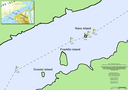
L'isola Hans (Hans Ø in danese, île Hans in francese, Hans Island in inglese, Tartupaluk in inuktitut/groenlandese) è un isolotto disabitato di 1,3 km². È situato al centro del canale Kennedy nello stretto di Nares, che unisce la baia di Baffin e il mare di Lincoln. Hans è la più piccola delle tre isole del canale (le altre due sono l'isola Franklin e l'isola Crozier).
| Isola Hans Hans Ø Hans Island Tartupaluk | |
|---|---|
 | |
| Geografia fisica | |
| Localizzazione | Mar Glaciale Artico |
| Coordinate | 80°49′29.95″N 66°27′02.48″W |
| Arcipelago | Isole Regina Elisabetta |
| Superficie | 1,30 km² |
| Geografia politica | |
| Stato | Isola divisa tra: |
| Territorio canadese | |
| Nazione costitutiva danese | |
| Regione amministrativa | Regione di Qikiqtaaluk |
| Comune groenlandese | Avannaata |
| Demografia | |
| Abitanti | Disabitata |
| Cartografia | |
 | |
 Isola Hans | |
| voci di isole presenti su Wikipedia | |
Storia
La sovranità sull'isola è stata oggetto di una disputa tra Canada e Danimarca dal 1973[2] al 2022, la guerra del whisky. La Danimarca rivendicava il territorio che avrebbe scoperto nel 1852 (da parte del danese Hans Hendrik), mentre il Canada affermava che l'isola fosse stata scoperta da un esploratore britannico e che geologicamente appartiene al suolo canadese.
L'interesse per il piccolo lembo di terra è legato al riscaldamento globale, con gli esperti che stimano tra il 2004 e il 2080 un allungamento della navigabilità del canale da 20 a 150 giorni l'anno, con la possibilità dello sfruttamento del petrolio.
Secondo Peter Taksøe-Jensen, allora membro dell'Ufficio delle Nazioni Unite per gli affari legali, una curiosa abitudine dei militari di entrambi i Paesi, che periodicamente visitavano l'isola per sostenere le proprie rivendicazioni, era quella di sostituire la bandiera degli altri con quella del proprio Paese e di lasciare una bottiglia di akvavit danese o di whisky canadese.[3]
L'11 giugno 2022 i due Stati artici decisero di porre fine alla lunga disputa e suddividere a metà l'isola, firmando il 14 giugno un accordo in tal senso e creando un confine terrestre tra loro. L'accordo, tuttavia, entrerà in vigore solo dopo l'approvazione da parte dei due parlamenti nazionali (quello canadese e quello danese) e di quelli subnazionali (groenlandese e del Nunavut).
Note
- Canada e Danimarca raggiungono un accordo per dividere un isola artica disabitata, su cbc.ca. URL consultato il 16 giugno 2022.
- (EN) Canada and Denmark Fight Over Island With Whisky and Schnapps, su nytimes.com, 7 novembre 2016. URL consultato il 14 luglio 2017.
- (EN) Michael Byers, Who owns the Arctic? : understanding sovereignty disputes in the North, 1st U.S., Vancouver, Douglas & McIntyre, 2009, pp. 26–27, ISBN 978-1-55365-499-5.
Altri progetti
 Wikimedia Commons contiene immagini o altri file su isola Hans
Collegamenti esterni
- Hans Island: A border dispute between Denmark and Canada Archiviato il 25 novembre 2005 in Internet Archive. - Background, maps, timeline about the Hans Island dispute.
- NPR's Morning Edition, Friday, Aug 12, 2005 - Summary of the dispute.
- Newsletter No.3 HDMS Triton - about the August 1, 2003 landing on the island.
- CASR Archiviato il 17 aprile 2008 in Internet Archive. - article on the dispute by the Canadian American Strategic Review.
- Caryophyllaceae of the Canadian Arctic Archipelago, su mun.ca.
- Flora of the Canadian Arctic Archipelago, su mun.ca.
- Canadian Archipelago Throughflow Study, su udel.edu.
- Crisis in the Arctic!, su independentsources.com.
- Canadian perspective, March 29, 2004 (updated), su ghostofaflea.com.
- The Globe and Mail: Denmark won't provoke 'flag war' over Hans Island, su theglobeandmail.com.
- Principality of Tartupaluk Archiviato il 7 febbraio 2012 in Internet Archive. A student claiming the island.
На других языках
[de] Hans-Insel
Die Hans-Insel (grönländisch Tartupaluk, Inuktitut ᑕᕐᑐᐸᓗᒃ .mw-parser-output .Latn{font-family:"Akzidenz Grotesk","Arial","Avant Garde Gothic","Calibri","Futura","Geneva","Gill Sans","Helvetica","Lucida Grande","Lucida Sans Unicode","Lucida Grande","Stone Sans","Tahoma","Trebuchet","Univers","Verdana"}Tartupaluk, dänisch Hans Ø, englisch Hans Island, französisch Île Hans) ist eine kleine, unbewohnte und vegetationslose Insel in der Nares-Straße mit einer Fläche von etwa 1,25 km².[1] Nach jahrzehntelangen Territorialstreitigkeiten zwischen Kanada und dem Königreich Dänemark wurde die Insel am 14. Juni 2022 zwischen beiden Staaten aufgeteilt.[2] Der kanadische Teil gehört zur Region Qikiqtaaluk (Baffin) des Territoriums Nunavut, der dänische Teil zum Distrikt Qaanaaq der grönländischen Kommune Avannaata Kommunia.[en] Hans Island
Hans Island (Inuktitut and Greenlandic: Tartupaluk, lit. 'kidney shaped';[2] Inuktitut syllabics: ᑕᕐᑐᐸᓗᒃ; Danish: Hans Ø; French: Île Hans) is a Canadian and Greenlandic (Denmark) island in the very centre of the Kennedy Channel of Nares Strait in the high Arctic region. The island itself is barren and uninhabited with an area of 1.3 square kilometres (0.50 sq mi), measuring 1,290 by 1,199 metres (4,232 by 3,934 ft), and a maximum elevation of 168.17 m (551.7 ft).[3] Its location in the strait that separates Ellesmere Island of Canada from northern Greenland was for years a border dispute, the so-called Whisky War between the two countries of Canada and Denmark. Hans Island is the smallest of three islands in Kennedy Channel off the Washington Land coast; the others are Franklin Island and Crozier Island. The strait at this point is 35 km (22 mi) wide, placing the island within the territorial waters of both Canada and Denmark (Greenland). A 1,280 m (4,200 ft) long border traverses the island.[es] Isla Hans
Isla Hans (danés: Hans Ø, francés: Île Hans, groenlandés:Tartupaluk, Inuktitut:ᑕᕐᑐᐸᓗᒃ ,inglés: Hans Island) es una pequeña y deshabitada isla ubicada en el centro del canal Kennedy del estrecho de Nares y dividida entre Canadá y Dinamarca. Este estrecho separa la isla de Ellesmere en Canadá, del norte de Groenlandia, y conecta la bahía de Baffin con el mar de Lincoln. La isla Hans es la más pequeña de las tres islas del canal Kennedy, siendo las otras la isla Franklin y la isla Crozier. Solía ser un territorio en disputa, pero el 14 de junio de 2022 se decidió que la isla sería dividida cerca de la mitad entre Dinamarca y Canadá.[1] La parte canadiense pertenece a la Región Qikiqtaaluk del territorio de Nunavut, la parte danesa al distrito de Qaanaaq del municipio groenlandés de Avannaata.[fr] Île Hans
L’île Hans (Hans Ø en danois, Hans Island en anglais, ᑕᕐᑐᐸᓗᒃ en inuktitut et Tartupaluk en groenlandais) est un îlot situé au centre du passage Kennedy dans le détroit de Nares, entre l'île d'Ellesmere et le Groenland.- [it] Isola Hans
[ru] Ханс (остров)
Ханс (гренл. Tartupaluk; дат. Hans Ø; англ. Hans Island) — небольшой необитаемый остров в центре пролива Кеннеди, части пролива Нэрса. Длина острова — 1290 метров, ширина — 1199 метров. Площадь 1,3 км². Остров Ханс — самый маленький среди трёх островов в проливе Кеннеди. Ширина пролива здесь составляет 35 км, остров находится в территориальных водах Канады и Дании.Другой контент может иметь иную лицензию. Перед использованием материалов сайта WikiSort.org внимательно изучите правила лицензирования конкретных элементов наполнения сайта.
WikiSort.org - проект по пересортировке и дополнению контента Википедии