geo.wikisort.org - Isola
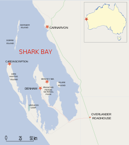
Dorre Island è un'isola disabitata al largo della costa dell'Australia Occidentale, di fronte alla città di Carnarvon, nella regione del Gascoyne. Appartiene alla Local government area della Contea di Carnarvon. L'isola, assieme a Bernier Island, chiude l'ingresso alla Shark Bay ed è bagnata a ovest dalle acque dell'oceano Indiano. Le due isole fanno parte della Bernier and Dorre Island Nature Reserve[1] all'interno della Shark Bay World Heritage area[2].
| Dorre Island | |
|---|---|
 | |
| Geografia fisica | |
| Localizzazione | Shark Bay |
| Coordinate | 24°52′S 113°10′E |
| Superficie | 60 (ca) km² |
| Dimensioni | 31,8 × 3,8 km |
| Geografia politica | |
| Stato | |
| Stato federato | |
| Regione | Gascoyne |
| Local government area | Contea di Carnarvon |
| Cartografia | |
 Dorre Island | |
| voci di isole dell'Australia presenti su Wikipedia | |
Geografia
Dorre Island, che ha una forma lunga e stretta, misura circa 31,8 km di lunghezza per 3,8 km di larghezza e ha una superficie di circa 60 km². A nord, alla distanza di 500 m, si trova Bernier Island. Cape St Cricq è il punto più meridionale, mentre Cape Boullanger è il punto più settentrionale dell'isola.[3]
Fauna
Il canguro striato[4] e il wallaby lepre rossiccio sono entrambe specie in pericolo di mammiferi che una volta erano stati trovati sulla terraferma, ma ora sono entrambi limitati alle isole Dorre e Bernier. Il wallaby lepre viene reintrodotto nell'Australia continentale.
Storia
L'isola prende il nome da Peter Dorre, pilota della nave olandese VOC Eendracht nel 1616.[5]
Visitate una prima volta dagli olandesi alla fine del 1600, Bernier Island e Dorre Island furono entrambe raggiunte da Nicolas Baudin, che guidò una spedizione francese di esplorazione delle coste dell'Australia.[6]
Sulle isole Bernier e Dorre venne allestita una struttura ospedaliera di isolamento nei primi anni del 1900. Furono utilizzate dal governo dell'Australia occidentale per condurre esperimenti sulle malattie veneree e la lebbra degli aborigeni che venivano prelevati con la forza da tutta l'area nord-occidentale. Dei 650 detenuti nelle isole, solo 490 tornarono sulla terraferma.[6][7]
Note
- (EN) Bernier and Dorre Islands Nature Reserve, su sharkbay.org. URL consultato il 13 maggio 2018.
- (EN) Shark Bay, Western Australia, su whc.unesco.org. URL consultato il 13 maggio 2018.
- Mappa: Dorre Island (JPG), su ga.gov.au. URL consultato il 14 maggio 2018.
- (EN) Mammal Species of the World, su departments.bucknell.edu. URL consultato il 14 maggio 2018.
- (EN) Henri Bencker, Fifty Years Ago..., in International Hydrographie Review, LXXI(2), Monaco, settembre 1994, p. 131.
- (EN) Bernier and Dorre Islands, su australiaforeveryone.com.au. URL consultato il 14 maggio 2018 (archiviato dall'url originale il 17 settembre 2017).
- (EN) History, su sharkbay.org. URL consultato il 14 maggio 2018.
Altri progetti
 Wikimedia Commons contiene immagini o altri file su Dorre Island
| Controllo di autorità | VIAF (EN) 315136765 |
|---|
На других языках
[de] Dorre Island
Dorre Island ist eine 30 Kilometer lange, sehr schmale Insel vor der Westküste von Australien.[en] Dorre Island
Dorre Island is one of three islands that make up the Bernier and Dorre Island Nature Reserve in the Shark Bay World Heritage area in Western Australia.[1][2] The island was named after Peter Dorre, the pilot of a Dutch vessel, the Eendracht, in 1616.[3][fr] Île Dorre
L'île Dorre (Dorre Island) est une île australienne d'Australie-Occidentale à une cinquantaine de kilomètres au large de Carnarvon, au sud de l'île Bernier, dans la baie des Requins (Shark Bay).- [it] Dorre Island
Другой контент может иметь иную лицензию. Перед использованием материалов сайта WikiSort.org внимательно изучите правила лицензирования конкретных элементов наполнения сайта.
WikiSort.org - проект по пересортировке и дополнению контента Википедии