geo.wikisort.org - Île
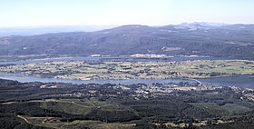
L’île de Puget (anglais : Puget Island) est une île fluviale du fleuve Columbia et une zone non-incorporée du comté de Wahkiakum dans l'État américain de Washington.
Le pont Julia Butler Hansen avec la Washington State Route 409 relie l'île à Cathlamet.
L'île est un refuge au Cerf à queue blanche de Colombie.
Elle est nommée d'après Peter Puget de l'expédition Vancouver.
- Portail de l’État de Washington
- Portail du monde insulaire
- Portail des lacs et cours d'eau
На других языках
[en] Puget Island, Washington
Puget Island is a 7.5 sq mi(4,785 acre; 19.365 km2) island and Census-designated place (CDP) in the Columbia River in Wahkiakum County, Washington, United States. The Julia Butler Hansen Bridge (built in 1938) carries State Route 409 across the Cathlamet Channel to connect the island to the town of Cathlamet, Washington. Route 409 crosses the island to its southern shore, where it connects with the county-operated Wahkiakum County Ferry, Oscar B, providing service to Westport, Oregon. The 2010 census reported a population of 831 persons.- [fr] Île de Puget
Текст в блоке "Читать" взят с сайта "Википедия" и доступен по лицензии Creative Commons Attribution-ShareAlike; в отдельных случаях могут действовать дополнительные условия.
Другой контент может иметь иную лицензию. Перед использованием материалов сайта WikiSort.org внимательно изучите правила лицензирования конкретных элементов наполнения сайта.
Другой контент может иметь иную лицензию. Перед использованием материалов сайта WikiSort.org внимательно изучите правила лицензирования конкретных элементов наполнения сайта.
2019-2025
WikiSort.org - проект по пересортировке и дополнению контента Википедии
WikiSort.org - проект по пересортировке и дополнению контента Википедии

