geo.wikisort.org - Île
L' île Thompson était une île fantôme dans le sud de l'océan atlantique. Elle était censée avoir été découverte à environ 150 km au nord-est de l'Île Bouvet.
Pour les articles homonymes, voir Île Thompson et Thompson.
| Île Thompson | |
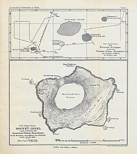
 Carte de l'Île Bouvet de 1898, avec Thompson I.. | |
| Géographie | |
|---|---|
| Localisation | Océan Atlantique |
| Coordonnées | 54° 33′ 00″ S, 5° 50′ 00″ E |
| modifier |
|
L'île aurait été découverte le par George Norris, le capitaine du Sprightly. Elle aurait été également aperçue 68 ans plus tard (en 1893) par Joseph J. Fuller à bord du Francis Allyn. Mais lorsqu'en novembre 1898 une équipe de chercheurs allemands a voulu déterminer la position précise de l'île dans le cadre de l'expédition Valdivia, elle n'a pas pu la retrouver. C'est lors de la Norwegian Antarctic Expedition (de 1928 à 1929) que cette île a été finalement déclaré comme inexistante par Ola Olstad et Nils Larsen.
Il est possible que l'île ait disparu dans les eaux à la suite d'une éruption volcanique entre 1893 et 1898 ; une étude menée dans les années 1960 confirme cette hypothèse[1].
Références
- (en) P.E. Baker, « Historical & Geological Notes on Bouvetoya », British Antarctic Survey Bulletin, vol. 13, , p. 71-84 (lire en ligne [PDF], consulté le ).
Voir aussi
Liens externes
- (en) « Smithsonian Institution - Global Volcanism Program »(Archive.org • Wikiwix • Archive.is • Google • Que faire ?) (consulté le )
- (en) Bibliographie des fictions en Antarctique
- Portail du monde insulaire
- Portail de la cartographie
На других языках
[en] Thompson Island (South Atlantic)
Thompson Island was a phantom island in the South Atlantic. It was thought to be about 70 km (43 mi; 38 nmi) north-northeast of Bouvet Island, a small Norwegian dependency between South Africa and Antarctica.- [fr] Île Thompson (île fantôme)
[ru] Томпсон (остров)
О́стров То́мпсон (англ. Thompson Island) — остров-призрак в Южной Атлантике. Согласно данным американской программы изучения всемирного вулканизма (англ. Global Volcanism Program), находился под 54°33′ ю. ш. 5°50′ в. д.HGЯO — около 70 км северо-северо-восточнее острова Буве (небольшого норвежского владения, расположенного между Южной Африкой и Антарктикой).Другой контент может иметь иную лицензию. Перед использованием материалов сайта WikiSort.org внимательно изучите правила лицензирования конкретных элементов наполнения сайта.
WikiSort.org - проект по пересортировке и дополнению контента Википедии
