geo.wikisort.org - Île
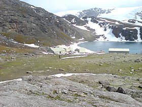
L'île Signy est une île appartenant à l'archipel des Îles Orcades du Sud en Antarctique. L'île mesure approximativement 6,5 km de long pour 5 km de large. Le point le plus élevé est à 288 m au-dessus du niveau de la mer. La majeure partie de l'île est recouverte de glace. Les températures moyennes oscillent entre 0 °C en été et −10 °C en hiver. L'île est nommée d'après la femme du chasseur de baleine norvégien Petter Sørlle.
Pour les articles homonymes, voir Signy.
| Île Signy | |

| |
| Géographie | |
|---|---|
| Continent | |
| Archipel | Îles Orcades du Sud |
| Localisation | Mer de Scotia |
| Coordonnées | 60° 42′ S, 45° 38′ O |
| Point culminant | 288 m |
| Administration | |
| Statut | Revendiqué par le Royaume-Uni et l'Argentine |
| Démographie | |
| Population | Aucun habitant |
| Autres informations | |
| modifier |
|
La British Antarctic Survey y a une station de recherche en biologie depuis 1947, là où se trouvait dans les années 1920 une station de chasse à la baleine. La station était occupée toute l'année jusqu'en 1996. Depuis, elle n'est plus occupée que de novembre à avril. Elle abrite une dizaine de personnes[1].
L'île est reconnue zone importante pour la conservation des oiseaux[2],[3].
Articles connexes
- Antarctique
- Liste des îles de l'Antarctique
Notes et références
- (en) Natural Environment Research Council, « ABOUT British Antarctic Survey », sur British Antarctic Survey (consulté le )
- « BirdLife Data Zone », sur datazone.birdlife.org (consulté le )
- « BirdLife Data Zone », sur datazone.birdlife.org (consulté le )
- Portail de l’Argentine
- Portail des Territoires britanniques d'outre-mer
- Portail du monde insulaire
- Portail de l’Antarctique
На других языках
[de] Signy Island
Signy Island ist eine subantarktische Insel der Südlichen Orkney-Inseln. Sie liegt unmittelbar südlich des zentralen Teils der Coronation-Insel, von ihr getrennt durch die 1,6 km breite Normanna Strait. Im Südwesten ist ihr die 1,2 km² große Insel Moe Island vorgelagert. Signy Island ist 6 Kilometer lang, bis zu 4,5 Kilometer breit[2] und erhebt sich bis zu 278 Meter über die Meeresoberfläche. Ihre Fläche beträgt 19,3 km².[1] Etwa die Hälfte der Insel ist von einer Eiskappe bedeckt. Der größte von mehreren Gletschern kalbt im Bereich der Clowes Bay im Süden direkt ins Meer. Im Sommer liegen große Flächen frei, die von Moos und einigen Gräsern bewachsen sind, und es entstehen viele Süßwasserbecken und -seen.[en] Signy Island
Signy Island is a small subantarctic island in the South Orkney Islands of Antarctica. It was named by the Norwegian whaler Petter Sørlle (1884–1933) after his wife, Signy Therese.[1][es] Isla Signy
La isla Signy pertenece al archipiélago de las islas Orcadas del Sur en la Antártida.- [fr] Île Signy
[ru] Сигню
Сигню (англ. Signy Island) — небольшой остров в архипелаге Южные Оркнейские острова в 1,6 километрах к югу от острова Коронейшен. Размеры острова около 6,5 на 5 километров. Самая высокая точка острова Тиога-Хилл[en] (290 м) — скальный выход в центре ледника Мак-Лауд[en]. Остров имеет статус особой орнитологической территории.Другой контент может иметь иную лицензию. Перед использованием материалов сайта WikiSort.org внимательно изучите правила лицензирования конкретных элементов наполнения сайта.
WikiSort.org - проект по пересортировке и дополнению контента Википедии
