geo.wikisort.org - Île
L'île Secretary, en anglais Secretary Island, est une île néo-zélandaise de la mer de Tasman séparée de l'île du Sud par les fjords de Doubtful Sound et Thompson Sound. D'une superficie de 81 km2, elle culmine à 1 200 mètres d'altitude. Inhabitée, elle fait entièrement partie du parc national de Fiordland.
 Portail du monde insulaire
  Portail de l’océan Pacifique
  Portail de la Nouvelle-Zélande
Cet article est une ébauche concernant le monde insulaire et la géographie de la Nouvelle-Zélande.
Vous pouvez partager vos connaissances en l’améliorant (comment ?) selon les recommandations des projets correspondants.
| Île Secretary Secretary Island (en) | ||
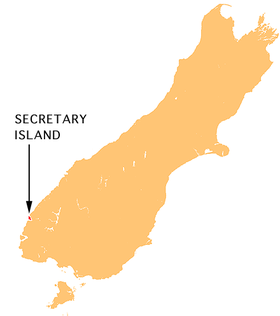 Carte de localisation de Secretary Island. | ||
| Géographie | ||
|---|---|---|
| Pays | ||
| Localisation | Mer de Tasman Océan Pacifique |
|
| Coordonnées | 45° 15′ S, 166° 55′ E | |
| Superficie | 81 km2 | |
| Point culminant | 1 200 m | |
| Administration | ||
| Région | Southland | |
| District | Southland | |
| Démographie | ||
| Population | Aucun habitant | |
| Autres informations | ||
| Géolocalisation sur la carte : Nouvelle-Zélande
| ||
| Îles en Nouvelle-Zélande | ||
| modifier |
||

На других языках
[de] Secretary Island
Secretary Island ist eine Insel im Fiordland National Park im Südwesten Neuseelands. Die Insel hat einen annähernd dreieckigen Grundriss mit den Ecken Common Head (Ostspitze), Colonial Head (Nordspitze) und der unbenannten Westspitze. Sie wird durch den Doubtful Sound/Patea im Süden und den Te Awa-o-Tū / Thompson Sound im Norden, die sich am Common Head im Pendulo Reach treffen, vom Festland getrennt. Die Westküste grenzt an die Tasmansee. Die steil ansteigende Insel erreicht eine Höhe von 1200 m bei einer Fläche von 81 km². Sie ist unbewohnt. Die nächstgelegene größere Insel ist Bauza Island im Süden.[en] Secretary Island
Secretary Island (Māori: Ka Tū-waewae-o-Tū) is an island in southwestern New Zealand, lying entirely within Fiordland National Park. Roughly triangular in shape, it lies between Doubtful Sound / Patea in the south and Te Awa-o-Tū / Thompson Sound in the north, with its west coast facing the Tasman Sea. To the east of the island, Pendulo Reach connects Te Awa-o-Tū / Thompson Sound with Doubtful Sound / Patea. Steeply sloped, the entirely bush-clad island rises to a chain of several peaks higher than 1000 metres. The highest of these is the 1,196-metre (3,924 ft) Mount Grono, the highest peak in the main New Zealand chain not located in the North or South Island. The island also contains three lakes. The largest, Secretary Lake, over 600 metres (2,000 ft) long, is located beneath Mount Grono at an altitude of 550 metres (1,800 ft).[1]- [fr] Île Secretary
[ru] Секретари (остров)
Секретари (англ. Secretary Island) — остров в Новой Зеландии. Административно входит в состав региона Саутленд.Текст в блоке "Читать" взят с сайта "Википедия" и доступен по лицензии Creative Commons Attribution-ShareAlike; в отдельных случаях могут действовать дополнительные условия.
Другой контент может иметь иную лицензию. Перед использованием материалов сайта WikiSort.org внимательно изучите правила лицензирования конкретных элементов наполнения сайта.
Другой контент может иметь иную лицензию. Перед использованием материалов сайта WikiSort.org внимательно изучите правила лицензирования конкретных элементов наполнения сайта.
2019-2026
WikiSort.org - проект по пересортировке и дополнению контента Википедии
WikiSort.org - проект по пересортировке и дополнению контента Википедии