geo.wikisort.org - Île
L'île San Cristóbal, en espagnol : Isla San Cristóbal, aussi appelée île Chatham, est une île d'Équateur située dans l'archipel des Galápagos.
Cet article est une ébauche concernant le monde insulaire et l’Équateur.
Vous pouvez partager vos connaissances en l’améliorant (comment ?) selon les recommandations des projets correspondants.
Consultez la liste des tâches à accomplir en page de discussion.
Pour les articles homonymes, voir San Cristóbal.
Ne pas confondre avec les autres îles appelées Chatham.
| Île San Cristóbal Île Chatham | ||
 Puerto Baquerizo Moreno, vue partielle du port. | ||
| Géographie | ||
|---|---|---|
| Pays | ||
| Archipel | Îles Galápagos | |
| Localisation | Océan Pacifique | |
| Coordonnées | 0° 53′ S, 89° 30′ O | |
| Superficie | 558 km2 | |
| Point culminant | Cerro San Joaquín (730 m) | |
| Géologie | ||
| Géologie | Île volcanique | |
| Type | Volcan de rift | |
| Morphologie | Volcan bouclier | |
| Activité | Inconnue | |
| Dernière éruption | Inconnue | |
| Code GVP | 353120 | |
| Administration | ||
| Province | Galápagos | |
| Démographie | ||
| Population | 5 600 hab. | |
| Densité | 10,04 hab./km2 | |
| Plus grande ville | Puerto Baquerizo Moreno | |
| Autres informations | ||
| Découverte | (Européens) | |
| Fuseau horaire | UTC-6 | |
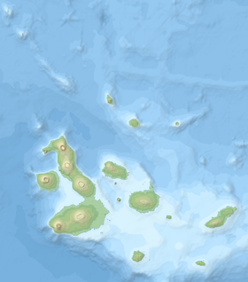
| Géolocalisation sur la carte : îles Galápagos
| ||
| Îles en Équateur - Île des îles Galápagos | ||
| modifier |
||
Toponymie
Cette île porte le nom espagnol de Saint Christophe, martyr. Indépendamment du fait que ce saint est traditionnellement considéré comme le patron des voyageurs, on pense raisonnablement à sa référence directe au prénom de Christophe Colomb, suivant en cela la tradition d'attribuer généralement aux îles de l'archipel des noms liés à Christophe Colomb et à sa première expédition.
L'ancien nom Chatham lui fut donné en l'honneur de Lord Chatham, par l'officier de marine anglais James Colnett en 1798, à l'occasion de son voyage le conduisant jusqu'aux îles Galápagos[1].
Topographie

Références
- (en) James Colnett, « A Voyage to the South Atlantic and Round Cape Horn into the Pacific Ocean. », London: W. Bennett., , p. 60.
Liens externes
- Ressources relatives à la géographie :
- Notices dans des dictionnaires ou encyclopédies généralistes :
 Portail des îles Galápagos
  Portail du monde insulaire
  Portail du volcanisme
На других языках
[de] San Cristóbal (Galápagos)
San Cristóbal oder Chatham ist die östlichste der Galápagosinseln und liegt etwa 965 km westlich der Festlandküste Ecuadors. Sie hat eine Fläche von 558 km², der höchste Punkt der Insel ist ein erloschener, stark erodierter Vulkan, der 730 Meter hoch ist. Durch die von ihm bedingten Niederschläge ist das Klima sehr feucht, während es auf der flachen Nordosthälfte der Insel sehr trocken ist. Durch die Kolonisierung wurde der Wasserhaushalt der Insel stark beeinflusst und die typische Feuchtvegetation wurde auf wenige Gebiete zurückgedrängt. Intensive Aufforstungsmaßnahmen sollen dazu beitragen, den ursprünglichen Zustand der Feuchtgebiete wiederherzustellen. Durch die Besiedlung wurde auch die Tierwelt stark verändert.[en] San Cristóbal Island
San Cristóbal Island (Spanish: Isla San Cristóbal) and named previously by the English as Chatham Island, is the easternmost island in the Galápagos archipelago,[1] as well as one of the oldest geologically. It is administratively part of San Cristóbal Canton, Ecuador.[es] Isla de San Cristóbal (Ecuador)
San Cristóbal es la isla más oriental del archipiélago de las islas Galápagos, en Ecuador.- [fr] Île San Cristóbal
[ru] Сан-Кристобаль (остров, Галапагос)
Сан-Кристобаль (Чатем)[1] (исп. Isla San Cristóbal, англ. Chatham) — самый восточный из островов Галапагос. Административный центр провинции Галапагос, город Пуэрто-Бакерисо-Морено, расположен на юго-восточном отроге Сан-Кристобаля.Другой контент может иметь иную лицензию. Перед использованием материалов сайта WikiSort.org внимательно изучите правила лицензирования конкретных элементов наполнения сайта.
WikiSort.org - проект по пересортировке и дополнению контента Википедии