geo.wikisort.org - Île
L'île Nelson est une île de la Sunshine Coast en Colombie-Britannique.
Cet article est une ébauche concernant le monde insulaire et la Colombie-Britannique.
Vous pouvez partager vos connaissances en l’améliorant (comment ?) selon les recommandations des projets correspondants.
Pour les articles homonymes, voir Île Nelson.
| île Nelson | ||
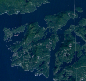 Situation de l'île Nelson. | ||
| Géographie | ||
|---|---|---|
| Pays | ||
| Localisation | détroit de Géorgie | |
| Coordonnées | 49° 42′ 00″ N, 124° 08′ 00″ O | |
| Superficie | 251 km2 | |
| Administration | ||
| Province | Colombie-Britannique | |
| Autres informations | ||
| Site officiel | http://www.bcislandhomes.com/community/nelson-island | |
| Géolocalisation sur la carte : Colombie-Britannique
| ||
| modifier |
||

Géographie
Entre la baie Hotham, le chenal Agamemnon et le détroit de Malaspina, elle est surtout couverte de forêts.
Histoire
Elle a commencé à être habitée au début des années 1800, essentiellement pour y exploiter le bois et le granite. Elle a aujourd'hui très peu d’habitants permanents.
Elle a été nommée en 1859 par George Henry Richards en l'honneur d'Horatio Nelson.
Lien externe
 Portail de la Colombie-Britannique
  Portail du monde insulaire
  Portail de l’océan Pacifique
На других языках
[en] Nelson Island (British Columbia)
Nelson Island is an island in the Sunshine Coast region of the South Coast region of British Columbia. It is surrounded by Hotham Sound, Agamemnon Channel, and Malaspina Strait. The closest communities are Pender Harbour, British Columbia and Egmont, both on the Sechelt Peninsula.- [fr] Île Nelson (Canada)
Текст в блоке "Читать" взят с сайта "Википедия" и доступен по лицензии Creative Commons Attribution-ShareAlike; в отдельных случаях могут действовать дополнительные условия.
Другой контент может иметь иную лицензию. Перед использованием материалов сайта WikiSort.org внимательно изучите правила лицензирования конкретных элементов наполнения сайта.
Другой контент может иметь иную лицензию. Перед использованием материалов сайта WikiSort.org внимательно изучите правила лицензирования конкретных элементов наполнения сайта.
2019-2025
WikiSort.org - проект по пересортировке и дополнению контента Википедии
WikiSort.org - проект по пересортировке и дополнению контента Википедии