geo.wikisort.org - Île
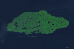
L’île Michipicoten (en anglais : Michipicoten Island) est une île canadienne située au nord-est du lac Supérieur. Elle mesure 27 km de long et 10 km de large. Elle possède un phare, construit en 1912 par Henri de Miffonis, à son extrémité orientale.
 Portail de l’Ontario
  Portail du monde insulaire
Cet article est une ébauche concernant le monde insulaire et l’Ontario.
Vous pouvez partager vos connaissances en l’améliorant (comment ?) selon les recommandations des projets correspondants.
Île Michipicoten
| Pays | |
|---|---|
| Localisation |
Ontario |
| Aire protégée |
Parc provincial Michipicoten Island (d) |
| Coordonnées |
47° 44′ 00″ N, 85° 45′ 00″ O |
| Baigné par | |
| Longueur |
27 km |
| Largeur |
10 km |
| Superficie |
184 km2 |
| Type |
Île |
|---|

На других языках
[de] Michipicoten Island
Michipicoten Island ist eine Insel im nordöstlichen Teil des Oberen Sees. Sie gehört zum Thunder Bay District der kanadischen Provinz Ontario.[en] Michipicoten Island
Michipicoten Island is an island in Ontario, Canada, in the northeastern part of Lake Superior, about 175 kilometres (109 mi) northwest of Sault Ste. Marie and 65 kilometres (40 mi) southwest of Wawa, Ontario.[2] At its closest point to mainland Ontario, the island is located about 16 kilometres (9.9 mi) from the mainland.[2] It falls within the boundaries of Thunder Bay District. The second largest island in Lake Superior (after Isle Royale),[3] Michipicoten Island is 27 kilometres (17 mi) long and 10 kilometres (6.2 mi) wide at its widest point.- [fr] Île Michipicoten
Текст в блоке "Читать" взят с сайта "Википедия" и доступен по лицензии Creative Commons Attribution-ShareAlike; в отдельных случаях могут действовать дополнительные условия.
Другой контент может иметь иную лицензию. Перед использованием материалов сайта WikiSort.org внимательно изучите правила лицензирования конкретных элементов наполнения сайта.
Другой контент может иметь иную лицензию. Перед использованием материалов сайта WikiSort.org внимательно изучите правила лицензирования конкретных элементов наполнения сайта.
2019-2026
WikiSort.org - проект по пересортировке и дополнению контента Википедии
WikiSort.org - проект по пересортировке и дополнению контента Википедии