geo.wikisort.org - Île
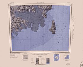
L’île Coulman est une île recouverte d’une calotte glaciaire et composée de plusieurs volcans bouclier. Elle se situe dans la mer de Ross au large de l'Antarctique. Le point culminant y atteint 1 998 mètres.
Découverte en 1841 par James Clark Ross, elle a été nommée du nom de son beau-père, Thomas Coulman.
Au cap Wadworth, un cylindre en métal attaché à un mat rouge, ayant servi de cache à messages par Robert F. Scott en 1902, est classé comme monument historique de l'Antarctique.
- Portail de l’Antarctique
- Portail du monde insulaire
На других языках
[de] Coulman-Insel
Die Coulman-Insel (englisch Coulman Island) ist eine eisbedeckte vulkanische Insel im Rossmeer der Antarktis. Sie befindet sich 14 km vor der Küste der Daniell-Halbinsel an der Borchgrevink-Küste des Viktorialands, davon getrennt durch die 15 Kilometer breite Glacier Strait. Die Insel besteht aus mehreren miteinander verbundenen Schildvulkanen. Sie wird von Kaiserpinguinen, Adeliepinguinen und Robben bewohnt.[en] Coulman Island
Coulman Island is an ice-covered island in the Ross Sea, located 14 km (8.7 mi) southeast of Cape Jones, Victoria Land, Antarctica. It is 33.3 km (20.7 mi) long, 14.8 km (9.2 mi) wide and 6,562 ft (2,000 m) in elevation. Emperor penguins inhabit this island. It was discovered in 1841 by Sir James Clark Ross who named it for his father-in-law, Thomas Coulman.[1] A notable landmark of this island is Cape Anne, the south-easternmost point of the island, so named by Sir James Clark Ross for his wife. Cape Wadworth is the northernmost point of the island.[es] Isla Coulman
La isla Coulman, situada en las coordenadas (73°5′S 169°06′E), es una isla cubierta por el hielo, formada por varios volcanes de escudo en el mar de Ross, de la Antártida. La caldera Coulman, mide 5 km de ancho y 700 m de profundidad, se encuentra en el sur de la isla. El pingüino emperador (Aptenodytes forsteri) habita esta isla y forma una importante colonia de cría. La isla tiene una altitud de 1998 m.- [fr] Île Coulman
[it] Isola di Coulman
L'isola di Coulman è un'isola ricoperta da una calotta glaciale e formata da vari vulcani a scudo. È situata nel mare di Ross al largo dell'Antartide. Culmina a 1998 m.Текст в блоке "Читать" взят с сайта "Википедия" и доступен по лицензии Creative Commons Attribution-ShareAlike; в отдельных случаях могут действовать дополнительные условия.
Другой контент может иметь иную лицензию. Перед использованием материалов сайта WikiSort.org внимательно изучите правила лицензирования конкретных элементов наполнения сайта.
Другой контент может иметь иную лицензию. Перед использованием материалов сайта WikiSort.org внимательно изучите правила лицензирования конкретных элементов наполнения сайта.
2019-2025
WikiSort.org - проект по пересортировке и дополнению контента Википедии
WikiSort.org - проект по пересортировке и дополнению контента Википедии

