geo.wikisort.org - Île
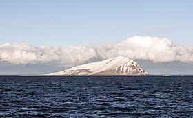
L'île Beaufort est une île inhabitée de l'archipel de Ross, dans la mer de Ross. Elle se situe à 19,3 km au nord du cap Bird de l'île de Ross.
Pour les articles homonymes, voir Beaufort.
| Île Beaufort Beaufort Island (en) | |
 L'île Beaufort et un iceberg | |
| Géographie | |
|---|---|
| Continent | |
| Archipel | Archipel de Ross |
| Localisation | Océan Austral |
| Coordonnées | 76° 56′ 00″ S, 166° 56′ 00″ E |
| Point culminant | Pic Paton (771 m) |
| Administration | |
| Démographie | |
| Population | Aucun habitant |
| Autres informations | |
| Découverte | 1841 |
| Îles en Antarctique | |
| modifier |
|
Histoire
Elle fut découverte par James Clark Ross en 1841, qui la nomma en honneur du capitaine Francis Beaufort de la Royal Navy, hydrographe de l'Amirauté.
Géographie
Le point culminant de l'île, le pic Paton (771 mètres), porte le nom de James Paton.
Notes et références
- (en) Cet article est partiellement ou en totalité issu de l’article de Wikipédia en anglais intitulé « Beaufort Island » (voir la liste des auteurs).
Articles connexes
- Liste des îles de l'Antarctique
- Antarctique
- Portail de l’Antarctique
- Portail du monde insulaire
На других языках
[de] Beaufort-Insel
Die Beaufort-Insel ist die nördlichste Insel des Ross-Archipels im antarktischen Rossmeer.[en] Beaufort Island
Beaufort Island is an island in Antarctica's Ross Sea. It is the northernmost feature of the Ross Archipelago,[1] lying 21 kilometres (13 miles) north of Cape Bird, Ross Island. It is approximately 18.4 km2 (7 square miles) in area. It was first charted by James Clark Ross in 1841. Ross named the island for Sir Francis Beaufort, hydrographer to the British Royal Navy.[2]- [fr] Île Beaufort
[ru] Остров Бофорта
Остров Бофорта — остров, расположенный в море Росса в Антарктике. Является самым северным из островов, относящихся к архипелагу Росса. Лежит в 21 километре к северу от мыса Бёрда, северной оконечности острова Росса. Нанесён на карту Джеймсом Россом в 1841 году во время его экспедиции на «Эребусе» и назван в честь сэра Фрэнсиса Бофорта, гидрографа королевского ВМФ Великобритании и создателя шкалы оценки скорости ветра.Текст в блоке "Читать" взят с сайта "Википедия" и доступен по лицензии Creative Commons Attribution-ShareAlike; в отдельных случаях могут действовать дополнительные условия.
Другой контент может иметь иную лицензию. Перед использованием материалов сайта WikiSort.org внимательно изучите правила лицензирования конкретных элементов наполнения сайта.
Другой контент может иметь иную лицензию. Перед использованием материалов сайта WikiSort.org внимательно изучите правила лицензирования конкретных элементов наполнения сайта.
2019-2025
WikiSort.org - проект по пересортировке и дополнению контента Википедии
WikiSort.org - проект по пересортировке и дополнению контента Википедии
