geo.wikisort.org - Île
Theodore Roosevelt Island est une île de 36 hectares de superficie située sur la rivière Potomac dans le Washington, D.C., où est implanté un mémorial national des États-Unis. Il fut donné par les américains pour l'association Theodore Roosevelt en mémoire de ce 26e président américain.
Cet article est une ébauche concernant le monde insulaire et les États-Unis.
Vous pouvez partager vos connaissances en l’améliorant (comment ?) selon les recommandations des projets correspondants.
| Columbia Island | |||
 Fontaine dans le parc Theodore Roosevelt Island. | |||
| Géographie | |||
|---|---|---|---|
| Pays | |||
| Localisation | Potomac | ||
| Coordonnées | 38° 53′ 50″ N, 77° 03′ 51″ O | ||
| Superficie | 0,36 km2 | ||
| Géologie | Île fluviale | ||
| Administration | |||
| Ville indépendante | Washington | ||
| Autres informations | |||
| Site officiel | www.nps.gov/this/index.htm | ||
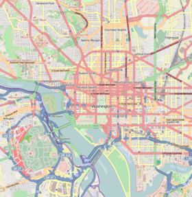
| Géolocalisation sur la carte : Washington
Géolocalisation sur la carte : États-Unis
| |||
| Île aux États-Unis | |||
| modifier |
|||

L'île a été convertie en parc naturel et comporte une statue commémorative de Théodore Roosevelt. Elle accessible uniquement par une passerelle piétonne à partir d'Arlington sur la rive ouest du Potomac.
Liens externes
- (en) Site officiel
- Ressources relatives à la géographie :
- Ressources relatives à l'architecture :
- (en) Harpers Ferry Center
- (en) National Park Foundation
- (en) NPS Stats
- (en) Registre national des lieux historiques
- (en) Theodore Roosevelt Island sur le site du National Park Service]
- Vue aérienne de l'île
 Portail de Washington, D.C.
  Portail du monde insulaire
  Portail du Registre national des lieux historiques
На других языках
[de] Theodore Roosevelt Island
Theodore Roosevelt Island, früher als My Lord’s Island, Barbadoes Island, Mason’s Island, Analostan Island, und Anacostine Island bekannt[1], ist ein National Memorial, das sich im Potomac River in Washington, D.C. befindet. Sie teilt den Potomac in den breiteren linksseitigen Georgetown Channel und den rechtsseitigen Little River. Es wurde der amerikanischen Bevölkerung von der Theodore Roosevelt Association zur Erinnerung an den 26. US-Präsidenten Theodore Roosevelt geschenkt. Das Gelände des Denkmals besteht aus dem Platz mit der Statue von Roosevelt und zwei Zierbrunnen, das Gelände rundherum ist ein naturbelassener Park. Die Insel liegt nördlich von Columbia Island und kann über eine Fußgängerbrücke erreicht werden, die zu einem asphaltierten Fußweg führt. Die Brücke verbindet die Insel mit dem Ufer des Potomac in Virginia. Am südlichen Ende der Insel liegt die kleine Insel Little Island. Vom Ostufer der Insel kann man das John F. Kennedy Center for the Performing Arts sehen.[en] Theodore Roosevelt Island
Theodore Roosevelt Island is an 88.5-acre (358,000 m2) island and national memorial located in the Potomac River in Washington, D.C.[1][2] During the Civil War, it was used as a training camp for the United States Colored Troops. The island was given to the federal government by the Theodore Roosevelt Association in memory of the 26th president, Theodore Roosevelt. Until then, the island had been known as My Lord's Island, Barbadoes Island, Mason's Island, Analostan Island, and Anacostine Island.[3]- [fr] Theodore Roosevelt Island
[ru] Остров Теодора Рузвельта
Остров Теодора Рузвельта — национальный мемориал на реке Потомак в Вашингтоне, округ Колумбия[3][4]. Остров передан в подчинение Федеральному правительству США Ассоциацией Теодора Рузвельта в память о 26-м президенте США. Прежде был известен под именами Остров моего Бога, Остров Барбадос, Остров Каменщика (калька Остров Масона), Остров Аналостан или Остров Анакостин[5].Текст в блоке "Читать" взят с сайта "Википедия" и доступен по лицензии Creative Commons Attribution-ShareAlike; в отдельных случаях могут действовать дополнительные условия.
Другой контент может иметь иную лицензию. Перед использованием материалов сайта WikiSort.org внимательно изучите правила лицензирования конкретных элементов наполнения сайта.
Другой контент может иметь иную лицензию. Перед использованием материалов сайта WikiSort.org внимательно изучите правила лицензирования конкретных элементов наполнения сайта.
2019-2026
WikiSort.org - проект по пересортировке и дополнению контента Википедии
WikiSort.org - проект по пересортировке и дополнению контента Википедии