geo.wikisort.org - Île
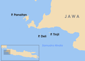
Panaitan est une île de l'océan Indien située à environ 10 km au large de la presqu'île d'Ujung Kulon à l'extrémité occidentale de l'île de Java en Indonésie. Elle fait partie du parc national d'Ujung Kulon.
Cet article est une ébauche concernant le monde insulaire, l’océan Indien et l’Indonésie.
Vous pouvez partager vos connaissances en l’améliorant (comment ?) selon les recommandations des projets correspondants.
| Panaitan | ||
 îles situées à l'ouest de Java | ||
| Géographie | ||
|---|---|---|
| Pays | ||
| Localisation | Grandes îles de la Sonde | |
| Coordonnées | 6° 34′ 31″ S, 105° 12′ 36″ E | |
| Point culminant | Gunung Raksa (329 m) | |
| Administration | ||
| Province | Banten | |
| Kabupaten | Pandeglang | |
| Autres informations | ||
| Géolocalisation sur la carte : Indonésie
| ||
| modifier |
||

Administrativement, l'île fait partie du kabupaten de Pandeglang dans la province de Banten.
Histoire

On a trouvé des statues de Ganesha et de Shiva au sommet du mont Raksa. On estime qu'elles datent du Ier siècle apr. J.-C.[1]
On pense que Panaitan était une escale pour les bateaux qui empruntaient le détroit de la Sonde[2]. James Cook y a jeté l'ancre du 6 au .
Les Hollandais appelaient l'île Princen Eiland, "l'île au Prince".
Tourisme

Panaitan fait partie du parc national d'Ujung Kulon.
L'île est un spot de surf. L'île serait menacée par l'installation d'un camp par un opérateur peu scrupuleux[3].
Notes et références
- Mal Clarbrough, 1996
- Blower and van der Zon, 1977
- (en) Save the Waves Coalition
Voir aussi
 Portail du monde insulaire
  Portail de l’océan Indien
  Portail de l’Indonésie
На других языках
[de] Panaitan
Panaitan, Bahasa Indonesia: Pulau Panaitan, wörtlich übersetzt Prinzeninsel, früher entsprechend niederländisch Prinseneiland, ist die größte indonesische Insel in der Sundastraße am Rande der Javasee zwischen Java und Sumatra.[en] Panaitan
Panaitan (Prinsen, or Prince's Island; sometimes also Princess Island) (1450 m) is an island in the Sunda Strait, between Java and Sumatra, and in the Indonesian province of Banten. It is the largest island in the strait, and is located near the westernmost tip of Java (Java Head). Like the nearby Krakatoa, it too is volcanic in origin, although there are no known historic eruptions. The name 'Prince's Island' apparently is because the island was considered the property of Javan princes. Administratively, the island is a part of Pandeglang Regency.- [fr] Panaitan
[it] Panaitan
Panaitan (in lingua indonesiana Pulau Panaitan, letteralmente «isola del principe»; precedentemente nota in olandese come Prinseneiland), è la più grande isola indonesiana nello stretto della Sonda, il tratto periferico del mar di Giava che si stende tra Giava e Sumatra.[ru] Панайтан
Пана́йтан[1][2], также Панаи́тан[3] (индон. Pulau Panaitan, Принсен[2]) — крупнейший остров в Зондском проливе, расположен вблизи самой западной точки острова Ява. В административном отношении входит в состав округа Пандегланг индонезийской провинции Бантен. Имеет вулканическое происхождение. Полностью входит в состав национального парка Уджунг-Кулон[4].Другой контент может иметь иную лицензию. Перед использованием материалов сайта WikiSort.org внимательно изучите правила лицензирования конкретных элементов наполнения сайта.
WikiSort.org - проект по пересортировке и дополнению контента Википедии