geo.wikisort.org - Île
Lehua est une petite île en forme de croissant située à 1,1 km au nord de Ni'ihau. L'île elle-même était formée d'un cône de cendres relié au volcan éteint de Ni'ihau.
Cet article est une ébauche concernant le monde insulaire et Hawaï.
Vous pouvez partager vos connaissances en l’améliorant (comment ?) selon les recommandations des projets correspondants.
| Lehua | |||
| Géographie | |||
|---|---|---|---|
| Pays | |||
| Archipel | Hawaï | ||
| Localisation | Océan Pacifique | ||
| Coordonnées | 22° 01′ 12″ N, 160° 05′ 51″ O | ||
| Superficie | 1,03 km2 | ||
| Administration | |||
| État | Hawaï | ||
| Comté | Kauai | ||
| Démographie | |||
| Population | Aucun habitant (2012) | ||
| Autres informations | |||
| Géolocalisation sur la carte : Hawaï
Géolocalisation sur la carte : États-Unis
| |||
| Île aux États-Unis | |||
| modifier |
|||


Lehua était l'une des cinq premières îles découvertes par le capitaine James Cook en 1778, qu'il avait orthographié "Oreehoua"[1].
Galerie
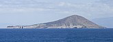 Rive ouest de Lehua
 Lehua vu de Niʻihau
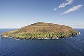 Lehua vu de l'ouest


Notes et références
- (en) John Galt, All the Voyages Round the World: From the First by Magellan, in 1520, to that of Freycinet, in 1820, W.H. Colyer, (lire en ligne)
 Portail d’Hawaï
  Portail du monde insulaire
На других языках
[de] Lehua
Lehua ist eine kleine, unbewohnte Insel im Archipel von Hawaiʻi. Sie liegt 1,1 km vom Puʻukole Point, dem nördlichsten Punkt Niʻihaus entfernt und gehört wie dieses zum Kauai County. Lehua ist auch der Name eines traditionellen Häuptlingstums (ahupuaʻa) im Norden der Insel Niʻihau, das in seiner Fläche von 179,9 km² auch die Insel Lehua umfasst.[1][en] Lehua
Lehua Island is a small, crescent-shaped island in the Hawaiian islands, 0.7 miles (1.1 km) north of Niʻihau, due west of Kauai. The uninhabited, 285-acre (1.15 km2) barren island is a tuff cone which is part of the active Niʻihau volcano.[1][es] Lehua
Lehua es una pequeña isla, con forma de medialuna a sólo 1,1 km (0,7 millas) al norte de Niʻihau. La isla, deshabitada, ocupa 284 acres (1,15 km²) y es una toba volcánica que forma parte del volcán extinguido de Niʻihau.- [fr] Lehua
[it] Lehua
Lehua è una piccola isola a forma di mezzaluna nelle isole Hawaii a soli 1,1 km a nord di Ni.mw-parser-output .Unicode{font-family:TITUS Cyberbit Basic,Code2000,Doulos SIL,Chrysanthi Unicode,Bitstream Cyberbit,Bitstream CyberBase,Bitstream Vera,Thryomanes,Gentium,GentiumAlt,Visual Geez Unicode,Lucida Grande,Arial Unicode MS,Microsoft Sans Serif,Lucida Sans Unicode;font-family:inherit}ʻihau. Disabitata, l'isola ha una superficie di 1,15 km² ed è la parte terminale del cono del vulcano estinto di Niʻihau.[ru] Лехуа
Леху́а (гав. Lehua [lɛˈhuə], [nɛˈhuə]) — небольшой остров в группе Гавайских островов. В административном отношении входит в состав округа Кауаи штата Гавайи, США.Текст в блоке "Читать" взят с сайта "Википедия" и доступен по лицензии Creative Commons Attribution-ShareAlike; в отдельных случаях могут действовать дополнительные условия.
Другой контент может иметь иную лицензию. Перед использованием материалов сайта WikiSort.org внимательно изучите правила лицензирования конкретных элементов наполнения сайта.
Другой контент может иметь иную лицензию. Перед использованием материалов сайта WikiSort.org внимательно изучите правила лицензирования конкретных элементов наполнения сайта.
2019-2026
WikiSort.org - проект по пересортировке и дополнению контента Википедии
WikiSort.org - проект по пересортировке и дополнению контента Википедии