geo.wikisort.org - Île
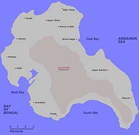
Katchal, anciennement Tihnyu, est une île de l'archipel des Nicobar dans le Golfe du Bengale.
Géographie
Katchal, située dans le groupe des îles du centre, mesure environ 19 km de longueur et 12 km de largeur maximales pour une superficie de 174,4 km2. Elle est distante de 7,5 kilomètres au sud-ouest de l'île de Camorta.
Histoire
- Portail du monde insulaire
- Portail de l’océan Indien
- Portail de l’Inde
На других языках
[de] Katchal
Katchal (Hindi: कत्चल, nicobarisch: तिहन्यु oder Tihnyu[1], früher auch Katsjul[2]) gehört zu der indischen Inselgruppe der Nikobaren im Golf von Bengalen, im Osten liegt die Andamanensee. Politisch gehört die Insel zum indischen Unionsterritorium Andamanen und Nikobaren.[en] Katchal Island
Katchal (Hindi: कत्चल, Nicobarese: तिहन्यु, Tihnyu) is one of the Nicobar Islands, India.[es] Katchal
Isla Katchal[1] (en hindi: कत्चल, en nicobar: तिहन्यु, Tihnyu) es una de las islas Nicobar, en la India. Su superficie es de 174,4 kilómetros cuadrados (61 millas cuadradas). Se trata de un territorio a aproximadamente 1.600 km (1.000 millas) de distancia de la parte continental (de India) y a 305 km (191 millas) al sur a la capital Puerto Blair.- [fr] Katchal
[ru] Катчалл
Катчал (англ. Katchal, хинди कत्चल, Кар: तिहन्यु, Tihnyu) — остров в центральной части архипелага Никобарских островов. Максимальная длина острова — 19 км, ширина — 12 км. Площадь — 174,4 км². По данным переписи 2001 года население составляет 5386 человек. Наивысшая точка над уровнем моря: 227 м.Текст в блоке "Читать" взят с сайта "Википедия" и доступен по лицензии Creative Commons Attribution-ShareAlike; в отдельных случаях могут действовать дополнительные условия.
Другой контент может иметь иную лицензию. Перед использованием материалов сайта WikiSort.org внимательно изучите правила лицензирования конкретных элементов наполнения сайта.
Другой контент может иметь иную лицензию. Перед использованием материалов сайта WikiSort.org внимательно изучите правила лицензирования конкретных элементов наполнения сайта.
2019-2025
WikiSort.org - проект по пересортировке и дополнению контента Википедии
WikiSort.org - проект по пересортировке и дополнению контента Википедии


