geo.wikisort.org - Île
Kahoolawe (en hawaïen Kaho`olawe) est la plus petite des huit îles principales de l’archipel d'Hawaï. Cette île est beaucoup plus basse que les autres parmi lesquelles elle se trouve, une géographie qui crée un climat beaucoup plus sec que les autres îles hawaïennes. Son littoral mesure 58 kilomètres de longueur[1].
Cet article est une ébauche concernant le monde insulaire et Hawaï.
Vous pouvez partager vos connaissances en l’améliorant (comment ?) selon les recommandations des projets correspondants.
| Kahoolawe | |||
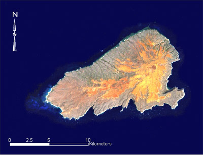 Image satellite de Kahoolawe. | |||
| Géographie | |||
|---|---|---|---|
| Pays | |||
| Archipel | Hawaï | ||
| Localisation | Océan Pacifique | ||
| Coordonnées | 20° 33′ N, 156° 36′ O | ||
| Superficie | 115,5 km2 | ||
| Côtes | 58 km | ||
| Point culminant | Puʻu Moaulanui (452 m) | ||
| Géologie | |||
| Géologie | Île volcanique | ||
| Type | Volcan de point chaud | ||
| Activité | Inconnue | ||
| Dernière éruption | Inconnue | ||
| Code GVP | 332801 | ||
| Observatoire | Observatoire volcanologique d'Hawaï | ||
| Administration | |||
| État | |||
| Démographie | |||
| Population | Aucun habitant | ||
| Autres informations | |||
| Fuseau horaire | UTC−10:00 | ||
| Site officiel | kahoolawe.hawaii.gov | ||
| Géolocalisation sur la carte : États-Unis
Géolocalisation sur la carte : Hawaï
| |||
| Îles aux États-Unis | |||
| modifier |
|||


L’île n’a jamais pu soutenir une population de plus de mille habitants environ. Tous les habitants furent évacués en , après l’entrée des États-Unis dans la Seconde Guerre mondiale. Entre 1941 et 1990, les forces armées américaines se servirent de l’île comme cible de bombardement — et ces activités militaires ont créé plusieurs difficultés écologiques autour de l’île.
En 1993, Kahoolawe ainsi qu'une bande côtière de 3 km est déclaré comme réserve.
La restauration écologique de l’île, commencée en 1994, continue.
Démographie

Voir aussi
Articles connexes
- Géographie d'Hawaï
Liens externes
- Ressource relative à l'architecture :
Notes et références
- (en) Charles Merguerian et Steven Okulewicz, Geology of Hawaii, Hofstra University Geology Department, , 140 p. (lire en ligne), p. 6.
- (en) « Statistiques des États-Unis - Hawaï - Profils des comtés de 2010 » (consulté en )
 Portail du monde insulaire
  Portail du volcanisme
  Portail de l’océan Pacifique
  Portail du Registre national des lieux historiques
  Portail d’Hawaï
На других языках
[de] Kahoʻolawe
Kahoʻolawe (alt auch Kahulaui,[1] engl. Kahoolawe, Kahoʻolawe im Geographic Names Information System[2]) ist die kleinste der acht vulkanischen Hauptinseln Hawaiis. Der Name bedeutet in der hawaiischen Sprache „das Wegnehmen (durch Strömung)“.[3] Sie liegt 11,2 km südwestlich von Maui und südöstlich von Lānaʻi und gehört zum Maui County. Die Insel darf nur mit Genehmigung betreten werden. Es gibt keine permanente Bevölkerung auf Kahoʻolawe.[en] Kahoolawe
Kahoʻolawe (Hawaiian: [kəˈhoʔoˈlɐve]), anglicized as Kahoolawe (/kɑːˌhoʊoʊˈlɑːweɪ, -veɪ/[3]), is the smallest of the eight main volcanic islands in the Hawaiian Islands. Kahoʻolawe is located about seven miles (11 km) southwest of Maui and also southeast of Lānaʻi, and it is 11 mi (18 km) long by 6.0 mi (9.7 km) wide, with a total land area of 44.97 sq mi (116.47 km2).[4] The highest point on Kahoʻolawe is the crater of Lua Makika at the summit of Puʻu Moaulanui, which is about 1,477 feet (450 m) above sea level.[5] Kahoʻolawe is relatively dry (average annual rainfall is less than 65 cm or 26 in)[6] because the island's low elevation fails to generate much orographic precipitation from the northeastern trade winds, and Kahoʻolawe is located in the rain shadow of eastern Maui's 10,023-foot-high (3,055 m) volcano, Haleakalā. More than one quarter of Kahoʻolawe has been eroded down to saprolitic hardpan soil, largely on exposed surfaces near the summit.[es] Kahoolawe
Kahoolawe (oficialmente en idioma hawaiano, Kahoʻolawe) es la isla más pequeña de las ocho islas mayores de Islas Hawái. Está situada a 11,2 km al suroeste de Maui y al sureste de Lanai (20°33′N 156°36′O). Administrativamente forma parte del condado de Maui. No tiene una población permanente.- [fr] Kahoolawe
[it] Kahoolawe
Kaho.mw-parser-output .Unicode{font-family:TITUS Cyberbit Basic,Code2000,Doulos SIL,Chrysanthi Unicode,Bitstream Cyberbit,Bitstream CyberBase,Bitstream Vera,Thryomanes,Gentium,GentiumAlt,Visual Geez Unicode,Lucida Grande,Arial Unicode MS,Microsoft Sans Serif,Lucida Sans Unicode;font-family:inherit}ʻolawe (Hawaiano: kəˈhoʔoˈlɐve) è la più piccola delle otto principali isole dell'arcipelago delle Hawaii, localizzata a circa 11 km a sudovest di Maui. È stata sempre scarsamente abitata ed attualmente non è abitata in maniera stabile.[ru] Кахоолаве
Кахоолаве (гав. Kahoʻolawe)[К 1] — один из островов Гавайского архипелага, наименьший по площади среди группы из восьми относительно крупных Гавайских островов (площадь 116,5 км²)[2].Другой контент может иметь иную лицензию. Перед использованием материалов сайта WikiSort.org внимательно изучите правила лицензирования конкретных элементов наполнения сайта.
WikiSort.org - проект по пересортировке и дополнению контента Википедии