geo.wikisort.org - Île
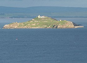
Inchkeith est une île du Firth of Forth en Écosse. Elle se situe au large de Leith, Édimbourg, mais fait officiellement partie de Kinghorn, Fife.
| Inchkeith | |
 Inchkeith vue depuis Kinghorn. | |
| Géographie | |
|---|---|
| Pays | |
| Archipel | Îles Britanniques |
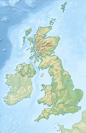
| Localisation | Firth of Forth (Mer du Nord) |
| Coordonnées | 56° 02′ 00″ N, 3° 08′ 06″ O |
| Géologie | Île continentale |
| Administration | |
| Nation constitutive | Écosse |
| Council Area | Fife |
| Autres informations | |
| Découverte | Préhistoire |
| Fuseau horaire | UTC+0 |
| Îles au Royaume-Uni | |
| modifier |
|
L'île a la particularité d'avoir les plus faibles précipitations d'Écosse, avec 550 millimètres par an.
Inchkeith a été utilisée à des fins militaires dès le XVIe siècle. On y trouve des traces d'emplacements de mitrailleuses remontant au XIXe siècle, à la Première Guerre mondiale et à la Seconde Guerre mondiale.
Aujourd'hui cette île est une propriété privée et il est nécessaire de posséder une autorisation pour y accoster.
Phare
Lien externe
Voir aussi
- Îles du Firth of Forth
- Portail de l’Écosse
- Portail du monde insulaire
- Portail de la mer du Nord
На других языках
[en] Inchkeith
Inchkeith (from the Scottish Gaelic: Innis Cheith) is an island in the Firth of Forth, Scotland, administratively part of the Fife council area.- [fr] Inchkeith
[ru] Инчкит
Инчки́т (англ. Inchkeith) — один из нескольких островов, расположенных в заливе Ферт-оф-Форт у восточных берегов Шотландии, близ Эдинбурга. Административно входит в состав области Файф.Текст в блоке "Читать" взят с сайта "Википедия" и доступен по лицензии Creative Commons Attribution-ShareAlike; в отдельных случаях могут действовать дополнительные условия.
Другой контент может иметь иную лицензию. Перед использованием материалов сайта WikiSort.org внимательно изучите правила лицензирования конкретных элементов наполнения сайта.
Другой контент может иметь иную лицензию. Перед использованием материалов сайта WikiSort.org внимательно изучите правила лицензирования конкретных элементов наполнения сайта.
2019-2025
WikiSort.org - проект по пересортировке и дополнению контента Википедии
WikiSort.org - проект по пересортировке и дополнению контента Википедии
