geo.wikisort.org - Île
L'île Conanicut est une île située dans la baie de Narragansett dans l'État américain de Rhode Island. D'une superficie de 24,46 km2, elle comptait 5 622 habitants en 2000. La ville de Jamestown comprend la totalité du territoire de l'île.
Cet article est une ébauche concernant le monde insulaire et le Rhode Island.
Vous pouvez partager vos connaissances en l’améliorant (comment ?) selon les recommandations des projets correspondants.
| Île Conanicut Conanicut Island (en) | |||
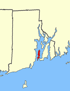 L'île Conanicut en rouge, en noir les frontières de l'État, Block Island est visible au large. | |||
| Géographie | |||
|---|---|---|---|
| Pays | |||
| Localisation | Baie de Narragansett | ||
| Coordonnées | 41° 31′ 16″ N, 71° 22′ 41″ O | ||
| Superficie | 24,46 km2 | ||
| Administration | |||
| État | Rhode Island | ||
| Comté | Newport | ||
| Démographie | |||
| Population | 5 622 hab. (2000) | ||
| Densité | 229,84 hab./km2 | ||
| Plus grande ville | Jamestown | ||
| Autres informations | |||
| Géolocalisation sur la carte : États-Unis
Géolocalisation sur la carte : Rhode Island
| |||
| Îles aux États-Unis | |||
| modifier |
|||

Le Claiborne Pell Newport Bridge, pont suspendu inauguré en 1969, relie l'île Aquidneck à Conanicut et le Jamestown-Verrazano Bridge, pont inauguré en 1992, relie l'île à North Kingstown.
De 1900 à la Seconde Guerre mondiale, l'île comportait un fort militaire, Fort Getty.
 Portail de Rhode Island
  Portail du monde insulaire
На других языках
[de] Conanicut Island
Conanicut Island ist die zweitgrößte Insel im Narragansett Bay im Bundesstaat Rhode Island. Die Newport Bridge verbindet die Insel im Osten mit Aquidneck Island und Newport. Außerdem bildet die Jamestown-Verrazano Bridge die Verbindung mit North Kingstown und dem Festland. Auf der Insel liegt der Ort Jamestown. Das United States Census Bureau dokumentiert eine Landfläche von 24,46 km² und 5.622 Einwohner nach dem Zensus von 2000.[en] Conanicut Island
Conanicut Island is the second-largest island in Narragansett Bay in the American state of Rhode Island. It is connected on the east to Newport on Aquidneck Island via the Claiborne Pell Bridge, commonly known as the Newport Bridge, and on the west to North Kingstown on the mainland via the Jamestown-Verrazano Bridge. The town of Jamestown comprises the entire island. The U.S. Census Bureau reported a land area of 24.46 km2 (9.44 sq mi) and a population of 5,622 in 2000.- [fr] Île Conanicut
[it] Conanicut
L'isola di Conanicut appartiene alla contea di Newport. Di fronte al porto di Newport ubicato nell'insenatura principale dell'isola più grande, Aquidneck. Quest'isola fronteggia a ovest la contea di Washington. A settentrione vi è l'isola di Prudence, la più piccola tra le maggiori dello stretto del Rhode Island.[ru] Конаникут
Конаникут (англ. Conanicut Island) — второй по площади остров в заливе Наррагансетт.Текст в блоке "Читать" взят с сайта "Википедия" и доступен по лицензии Creative Commons Attribution-ShareAlike; в отдельных случаях могут действовать дополнительные условия.
Другой контент может иметь иную лицензию. Перед использованием материалов сайта WikiSort.org внимательно изучите правила лицензирования конкретных элементов наполнения сайта.
Другой контент может иметь иную лицензию. Перед использованием материалов сайта WikiSort.org внимательно изучите правила лицензирования конкретных элементов наполнения сайта.
2019-2026
WikiSort.org - проект по пересортировке и дополнению контента Википедии
WikiSort.org - проект по пересортировке и дополнению контента Википедии