geo.wikisort.org - Isla
La isla Lowther se encuentra en el Archipiélago Ártico Canadiense, en la región Qikiqtaaluk del territorio de Nunavut. Es una de las islas que se encuentran en el sector oeste del Estrecho de Barrow.[1]
| Isla Lowther | ||
|---|---|---|
 | ||
| Ubicación geográfica | ||
| Archipiélago | Archipiélago Ártico Canadiense | |
| Coordenadas | 74°33′N 97°30′O | |
| Ubicación administrativa | ||
| País | Canadá | |
| División | Nunavut | |
| Subdivisión | Qikiqtaaluk | |
| Nunavut |
| |
| Características generales | ||
| Superficie | 145 | |
| Longitud | 27 km | |
| Anchura máxima | 3,2-9,7 km | |
| Punto más alto | 106,5 m (máx.) | |
| Población | ||
| Población | 0 hab. () | |
| Mapa de localización | ||
 Isla Lowther | ||
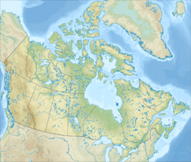
Las islas de Bathurst y Cornwallis están al norte mientras que la isla del Príncipe de Gales se localiza al sur.[2] La isla está rodeada de un grupo de islas deshabitadas. Está 24,9 km al noreste de la isla Young, separada de esta por el paso Kettle, una ruta utilizada por barcos, y 21 km al sureste de la Isla Garrett, separada de esta por el Canal Hayes.
La isla Lowther mide 27 km de largo y entre 3,2 y 9,7 km de ancho[3] y tiene una superficie de 145 km². Está bordeada por terrazas marinas, la mayor elevación es de 106,5 metros sobre el nivel del mar. La Gourdeau Point está en la vertiente sur de la isla y el Lowther Shoal, en la sur-sureste.[4]
Historia
El primer europeo que avistó la isla fue William Edward Parry en 1819.[5] Fue bautizada en nombre de un familiar de Hugh Lowther, V señor de Lonsdale, quien visitó la isla Lowther, que trabajó para la Compañía de la Bahía de Hudson.[6]
En agosto de 1852, Émile-Frédéric de Bray, en busca de Sir John Franklin, pasó una semana en la isla Lowther y cerca de la isla Griffith.[7] La isla fue visitado también por Francis Leopold McClintock como parte de la expedición de 1852 a 1854 conducida por Henry Kellett.[8]
Referencias
- Bourne, Charles B. (1963). Publication Centre, University of British Columbia, ed. Canadian Yearbook of International Law (en inglés). Vancouver. p. 101. ISBN 978-0-7748-0127-0.
- Pharand, Donat; Legault, L.H. (1984). The Northwest Passage: Arctic Straits. Martinus Nijhoff Publishers. p. 7. ISBN 90-247-2979-3.
- «Lowther Island». The Columbia Gazetteer of North America. 2000. Consultado el 28 de abril de 2008.
- Crawford, G.; Padman (L.). «Physical Oceanographic Observations from the Resolute 1995 Ice Camp, Barrow Strait» (pdf). Oregon State University. pp. 39-40. Consultado el 28 de abril de 2008.
- Parry, William Edward (1821). Journal of a voyage for the discovery of a North-West passage from the Atlantic to the Pacific: performed in the years 1819-20. Londres: John Murray.
- Birkenhead, Frederick E. (1977). Contemporary Personalities. Ayer Publishing. p. 229. ISBN 0-8369-0061-8.
- Bray, E. F. d., & Barr, W. (1992). A Frenchman in search of Franklin: de Brays Arctic journal, 1852-1854. Toronto: University of Toronto Press. pp. 48-50. ISBN 0-8020-2813-6.
- Mowat, Farley (1973). Ordeal by ice; the search for the Northwest Passage (The Fate of Franklin). Toronto: McClelland and Stewart Ltd. p. 288. OCLC 1391959.
Bibliografía
- Lowther Island en la Geografía de Canadá
Bibliografía adicional
Dyke, Arthur S. (1993). [ «Glacial and sea level history of Lowther and Griffith Islands, Northwest Territories: A hint of tectonics; vol. 47, n° 2»]. Géographie physique et Quaternaire (en inglés). pp. 133-45.
Enlaces externos
- Esta obra contiene una traducción derivada de «Lowther Island» de Wikipedia en inglés, concretamente de esta versión del 19 de marzo de 2013, publicada por sus editores bajo la Licencia de documentación libre de GNU y la Licencia Creative Commons Atribución-CompartirIgual 3.0 Unported.
На других языках
[de] Lowther Island
Lowther Island (Inuktitut Nannurqsiurqvik)[2] ist eine der Parry-Inseln in der Gruppe der Königin-Elisabeth-Inseln im kanadischen Territorium Nunavut.[en] Lowther Island
Lowther Island lies within the Arctic Archipelago in the Qikiqtaaluk Region of northern Canada's territory of Nunavut. It is one of the mid-channel islands in the western sector of Barrow Strait.[1] Bathurst Island and Cornwallis Island are to the north, while Prince of Wales Island is to the south.[2] The island is clustered within a group of uninhabited islands. It is 15.5 mi (24.9 km) northeast of Young Island, separated by the Kettle Passage, a shipping route, and 13 mi (21 km) southeast of Garrett Island, separated by Hayes Channel.- [es] Isla Lowther
Другой контент может иметь иную лицензию. Перед использованием материалов сайта WikiSort.org внимательно изучите правила лицензирования конкретных элементов наполнения сайта.
WikiSort.org - проект по пересортировке и дополнению контента Википедии