geo.wikisort.org - Island
Wallops Island is a six-square-mile (16 km2) island in Accomack County, Virginia, part of the Virginia Barrier Islands that stretch along the eastern seaboard of the United States of America.[1] It is just south of Chincoteague Island, a popular tourist destination.
 | |
 Wallops Island  Wallops Island | |
| Geography | |
|---|---|
| Coordinates | 37°51′N 75°28′W |
| Area | 6 sq mi (16 km2) |
| Administration | |
United States | |
| State | Virginia |
| County | Accomack County |
| Additional information | |
| Time zone |
|
| • Summer (DST) |
|
Wallops Island proper, originally known as Kegotank Island, was granted to John Wallop by the Crown on April 29, 1692. Ownership was divided through the years, until the Commonwealth of Virginia seized the property in 1876 and 1877 in lieu of unpaid taxes. From 1877, ownership was again divided and subdivided until 1889, when it was held by various trustees for the Wallops Island Club. The Club was incorporated and assumed ownership in 1933 as the Wallops Island Association, Inc. Association members and their families spent the summers fishing and swimming on the island. The Association grazed sheep, cattle, and ponies on the area until the mid-1940s. In 1947, the U.S. Navy began using the upper two-thirds of the island on a lease-rental basis for aviation ordnance testing. The National Advisory Committee for Aeronautics (NACA), forerunner of NASA, leased the lower 1,000 acres (4.0 km2) for rocket launching facilities.[2]
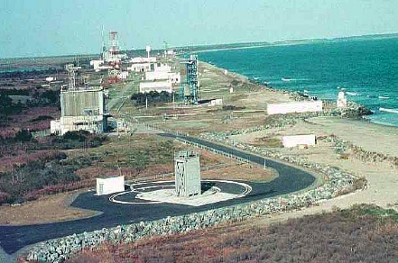
The island is used primarily for the Wallops Flight Facility, including the Mid-Atlantic Regional Spaceport, although the name also refers to the peninsula area surrounding the island for the purpose of mailing addresses. The Wallops Island National Wildlife Refuge is located on the island.
Some of the World War II film Our Father was filmed on Wallops Island.
Climate
| Climate data for Wallops Island, 1991–2020 normals, extremes 1966–present | |||||||||||||
|---|---|---|---|---|---|---|---|---|---|---|---|---|---|
| Month | Jan | Feb | Mar | Apr | May | Jun | Jul | Aug | Sep | Oct | Nov | Dec | Year |
| Record high °F (°C) | 79 (26) |
79 (26) |
86 (30) |
93 (34) |
97 (36) |
100 (38) |
102 (39) |
100 (38) |
96 (36) |
93 (34) |
82 (28) |
78 (26) |
102 (39) |
| Mean maximum °F (°C) | 65.9 (18.8) |
67.5 (19.7) |
74.7 (23.7) |
82.4 (28.0) |
88.2 (31.2) |
93.1 (33.9) |
95.5 (35.3) |
93.1 (33.9) |
89.5 (31.9) |
83.2 (28.4) |
73.8 (23.2) |
67.7 (19.8) |
96.4 (35.8) |
| Average high °F (°C) | 46.2 (7.9) |
48.5 (9.2) |
54.5 (12.5) |
64.3 (17.9) |
72.7 (22.6) |
81.3 (27.4) |
86.1 (30.1) |
84.2 (29.0) |
78.7 (25.9) |
69.1 (20.6) |
58.8 (14.9) |
50.5 (10.3) |
66.2 (19.0) |
| Daily mean °F (°C) | 37.9 (3.3) |
39.8 (4.3) |
45.8 (7.7) |
55.1 (12.8) |
64.1 (17.8) |
73.2 (22.9) |
78.2 (25.7) |
76.5 (24.7) |
70.8 (21.6) |
60.2 (15.7) |
49.7 (9.8) |
42.0 (5.6) |
57.8 (14.3) |
| Average low °F (°C) | 29.5 (−1.4) |
31.1 (−0.5) |
37.0 (2.8) |
45.9 (7.7) |
55.5 (13.1) |
65.1 (18.4) |
70.4 (21.3) |
68.7 (20.4) |
63.0 (17.2) |
51.4 (10.8) |
40.7 (4.8) |
33.5 (0.8) |
49.3 (9.6) |
| Mean minimum °F (°C) | 12.3 (−10.9) |
16.6 (−8.6) |
22.4 (−5.3) |
32.1 (0.1) |
42.4 (5.8) |
52.4 (11.3) |
60.5 (15.8) |
59.2 (15.1) |
49.6 (9.8) |
36.0 (2.2) |
25.9 (−3.4) |
19.3 (−7.1) |
9.9 (−12.3) |
| Record low °F (°C) | 0 (−18) |
−1 (−18) |
14 (−10) |
26 (−3) |
33 (1) |
43 (6) |
53 (12) |
48 (9) |
43 (6) |
29 (−2) |
19 (−7) |
4 (−16) |
−1 (−18) |
| Average precipitation inches (mm) | 3.15 (80) |
2.81 (71) |
3.91 (99) |
3.12 (79) |
3.20 (81) |
3.39 (86) |
4.37 (111) |
4.32 (110) |
4.33 (110) |
4.02 (102) |
2.88 (73) |
3.75 (95) |
43.25 (1,099) |
| Average snowfall inches (cm) | 3.5 (8.9) |
2.3 (5.8) |
0.7 (1.8) |
0.2 (0.51) |
0.0 (0.0) |
0.0 (0.0) |
0.0 (0.0) |
0.0 (0.0) |
0.0 (0.0) |
0.0 (0.0) |
0.0 (0.0) |
1.7 (4.3) |
8.4 (21) |
| Average precipitation days (≥ 0.01 in) | 10.8 | 9.4 | 10.9 | 10.5 | 11.0 | 10.1 | 10.7 | 9.0 | 8.4 | 8.4 | 8.7 | 10.5 | 118.3 |
| Average snowy days (≥ 0.1 in) | 2.0 | 1.4 | 0.8 | 0.1 | 0.0 | 0.0 | 0.0 | 0.0 | 0.0 | 0.0 | 0.0 | 0.7 | 4.9 |
| Source: NOAA[3] | |||||||||||||
References
- "Wallops Island (Virginia)". Geographic Names Information System. United States Geological Survey.
- DeVincent-Hayes, Nan; Bowen Bennett (2001). Wallops Island. Images of America. Charleston, SC: Arcadia Publishing. pp. 9–10. ISBN 978-0-7385-0666-1.
- "NowData – NOAA Online Weather Data". National Oceanic and Atmospheric Administration. Retrieved March 4, 2022.
Authority control | |
|---|---|
| General |
|
| National libraries | |
| Other | |
На других языках
[de] Wallops Island
Wallops Island ist eine 15,5 km² große Insel im Atlantik vor der Küste des US-Bundesstaats Virginia. Sie ist Teil einer Inselkette, die sich an der Ostküste der Vereinigten Staaten erstreckt.- [en] Wallops Island
[fr] Île de Wallops
L'Île de Wallops (en anglais : Wallops Island) est une île de 16 km au large de la Eastern Shore de Virginie, qui s'étendent le long de la côte est des États-Unis. Elle est située dans le comté d'Accomack, en Virginie. L'île est juste au sud de Chincoteague, un quartier touristique de la destination.[it] Isola di Wallops
L'Isola di Wallops è un'isola di 16 km² situata lungo la costa orientale della Virginia nella Contea di Accomack. Fa parte delle Virginia Barrier Islands, una catena di isole sabbiose e strette separate dalla terraferma da stretti canali, che si estende lungo tutta la costa orientale della penisola di Delmarva. L'isola di Wallops si trova a sud dell'isola di Chincoteague, una popolare meta turistica.Другой контент может иметь иную лицензию. Перед использованием материалов сайта WikiSort.org внимательно изучите правила лицензирования конкретных элементов наполнения сайта.
WikiSort.org - проект по пересортировке и дополнению контента Википедии