geo.wikisort.org - Island
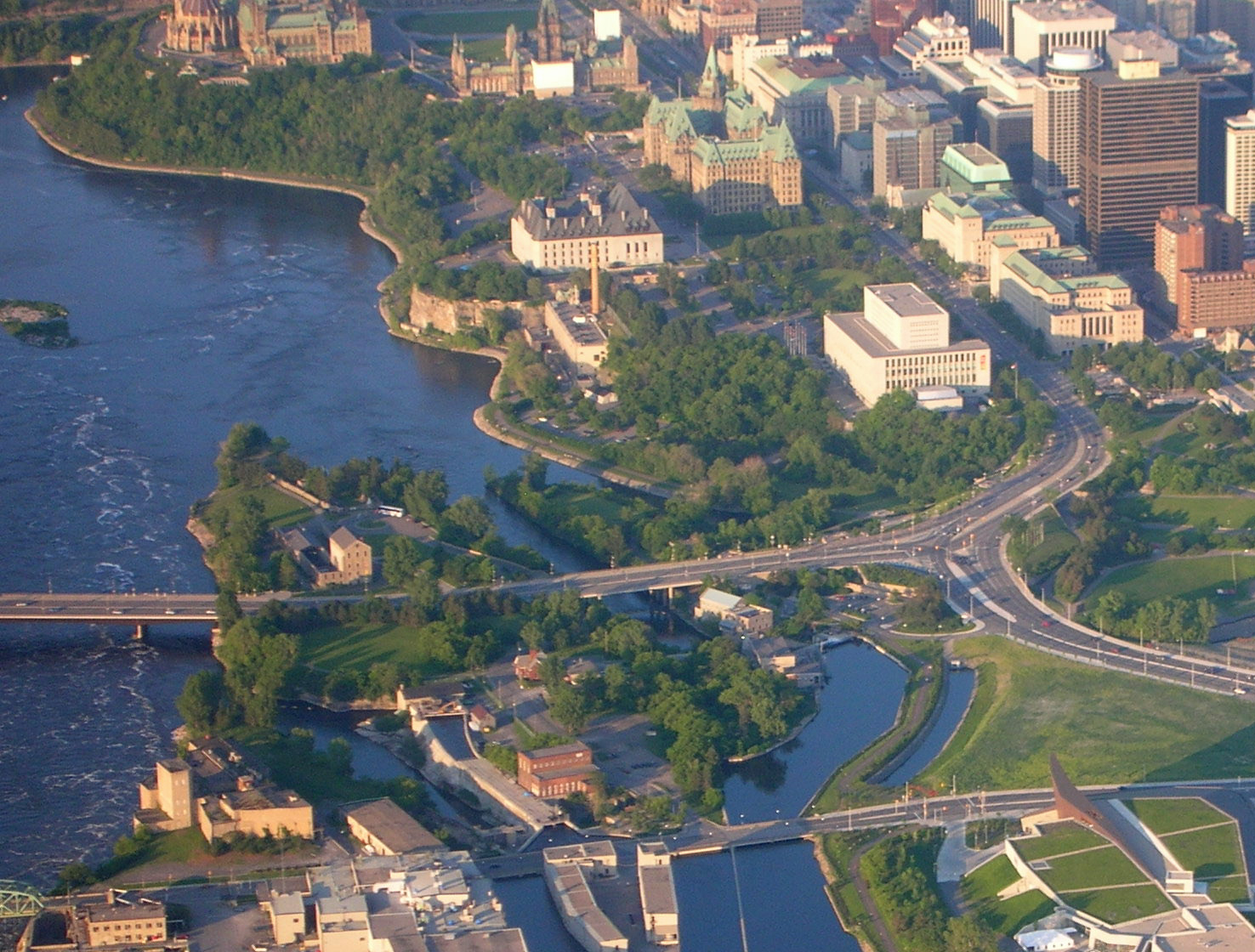
Victoria Island[5] (French: Île Victoria, Algonquin: Asinabka)[6] is an island in the Ottawa River, located north of LeBreton Flats, 1km west of Parliament Hill in Ottawa, Ontario, Canada. The island is "a place of special significance" to the local Algonquian peoples,[3] who use the island for ceremonial purposes and for protests.[7] It is part of an archipelago of islands below Chaudière Falls, which also includes the former Philemon Island, Chaudière Island, Amelia Island and Albert Island.[8]
Native name: Asinabka | |
|---|---|
 | |
 Victoria Island  Victoria Island | |
| Geography | |
| Location | Ottawa River |
| Coordinates | 45°25′15″N 75°42′46″W[1] |
| Area | 5.6 ha (14 acres)[3] |
| Length | 724 m (2375 ft) |
| Width | 205 m (673 ft) |
| Highest elevation | 54 m (177 ft)[4] |
| Highest point | Booth Street |
| Administration | |
Canada | |
| Province | Ontario |
| Census Division | Ottawa |
| Ward | Somerset Ward |
Both the Portage Bridge and Chaudière Bridge cross the island, connecting Ottawa to Gatineau, Quebec on the other side of the river. Otherwise, public access to the island is currently restricted due to an environmental remediation project set to be completed in 2025. [3] The project is projected to cost $13 million.[9]
History
Indigenous people were inhabiting the area up to 9,000 years ago, using the island to portage and for trade. The nearby Chaudière Falls was used for ceremonial purposes,[3] meetings, and as a burial site.[6] Beginning in the 19th century, the island was used for mixed industrial, commercial and residential uses,[3] and was home to a sawmill, and ironwork and manufacturing companies.[9] The Wilson Carbide Mill, named for Thomas Willson, the inventor of the process to produce calcium carbide and acetylene gas, was built on the island in 1900.[10] The mill, a four storey stone building, manufactured calcium carbide.[11] It has been recognized as a Federal Heritage Building.[10] Industrial use of the island has contaminated the land, resulting in the current clean up operation. This contamination was revealed through soil samples taken in 2017, revealing that the island's soil, groundwater and surface water were contaminated with ashes, lead, zinc and fuel oil.[9] The National Capital Commission (NCC) acquired most of the island in the 1960s, with the remainder being acquired in 2018 from Public Services and Procurement Canada. [3]
Protests
The island has a long history of Indigenous protests. In 1974, a group of protesters known as "The Native People's Caravan" occupied the Carbide Mill,[12] while in 1995 Aboriginal Defence League protesters broke into the mill and set up an "Aboriginal Embassy".[13] In 1988, Algonquins of Barriere Lake set up tents on the island to protest "the ravaging of their land by the federal and Quebec governments".[14] They returned in 1990, partly in solidarity of the Mohawk people in the Oka Crisis.[15] In 2013, Attawapiskat First Nation chief Theresa Spence took up residence on the island to protest against the Government of Canada.[6]
Future
Following the completion of the remediation project, the NCC plans to work with the Algonquin Anishinaabe Nation to develop a master plan for the island and to re-open it to the public.[3]
References
- "Victoria Island (Ottawa River)". Geographical Names Data Base. Natural Resources Canada.
- "Victoria Island (Ottawa River)". Geographical Names Data Base. Natural Resources Canada.
- "Site Remediation at Victoria Island". National Capital Commission.
- Ontario Base Survey
- "Victoria Island". Geographical Names Data Base. Natural Resources Canada.
- "NCC treats Spence camp as case of self-expression". Ottawa Citizen. January 10, 2013. Retrieved 2021-07-01.
- "Closing of Victoria Island in Ottawa catches some off guard". APTN.
- "A Glimpse of Chaudière Falls". Ottawa Citizen. April 30, 2015. Retrieved 2021-07-11.
- "NCC closing Victoria Island for 7 years to clean up contaminated soil". Global News.
- "Willson Carbide Mill". Canada's Historic Places.
- "Cold-busting flower may also clean polluted soil". Ottawa Citizen. January 24, 2014. Retrieved 2021-07-01.
- "Indians hold building". Ottawa Citizen. September 30, 1974. Retrieved 2021-07-01.
- "Aboriginal Embassy". Ottawa Citizen. March 20, 1995. Retrieved 2021-07-01.
- "Natives occupy island to protest land use". Ottawa Citizen. September 20, 1988. Retrieved 2021-07-01.
- "Camping Out". Ottawa Citizen. July 26, 1990. Retrieved 2021-07-01.
Другой контент может иметь иную лицензию. Перед использованием материалов сайта WikiSort.org внимательно изучите правила лицензирования конкретных элементов наполнения сайта.
WikiSort.org - проект по пересортировке и дополнению контента Википедии