geo.wikisort.org - Island
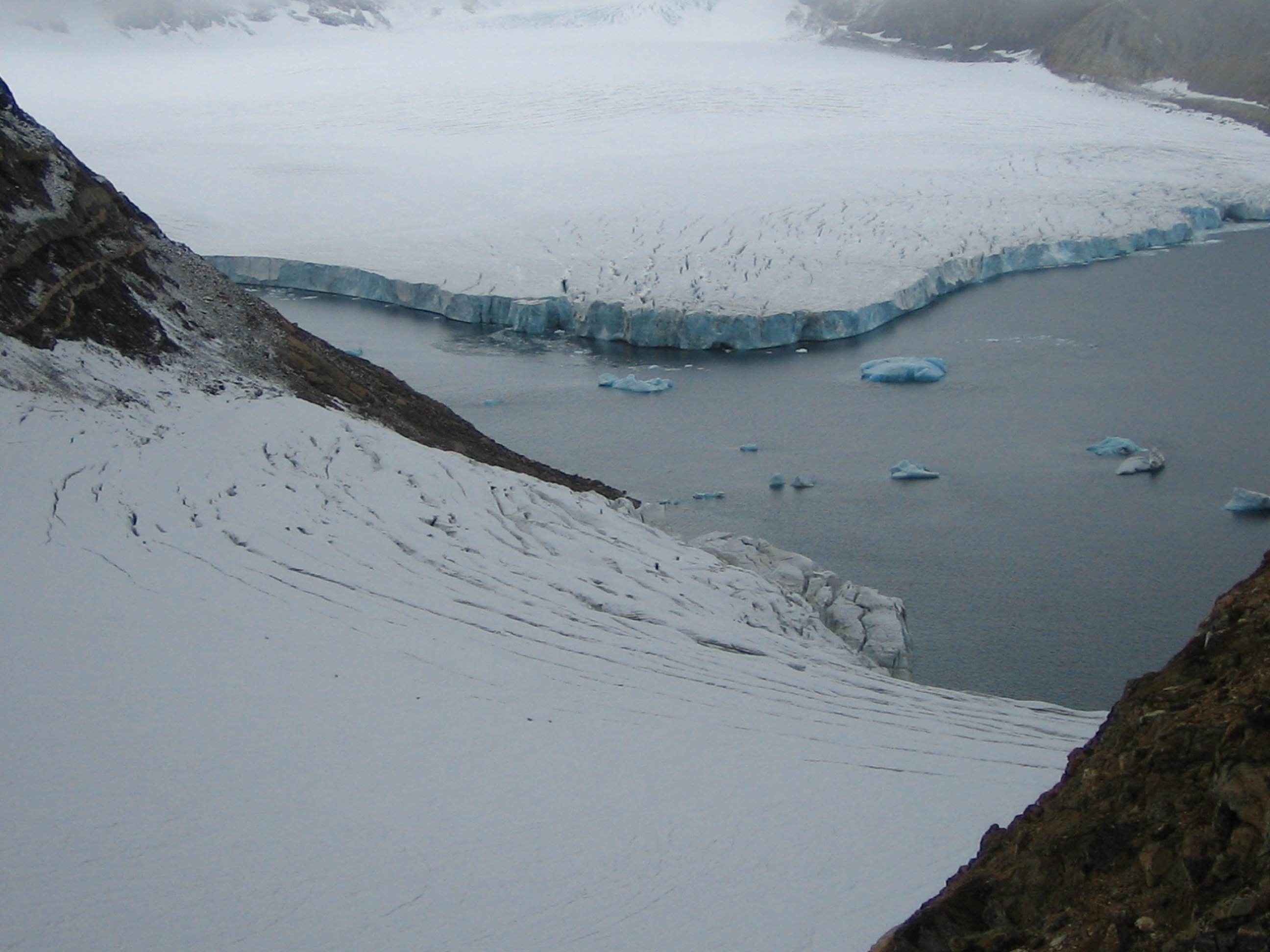
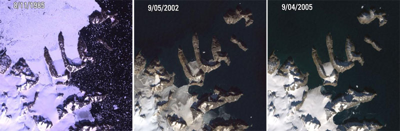
Uunartoq Qeqertaq (Greenlandic), Warming Island in English, is an island off the east central coast of Greenland, 550 kilometres (342 miles) north of the Arctic Circle. It became recognised as an island only in September 2005, by US explorer Dennis Schmitt. It was attached to the mainland of Liverpool Land by glacial ice even in 2002, when the ice shelves began retreating rapidly in this area, so that by 2005 it was no longer attached to the mainland. Members of the scientific community believe this newly discovered island is a direct result of global warming.[1]
Controversy
Patrick Michaels, a climatologist and prominent global warming denier, created a controversy over the history of Warming Island in a post on his website, World Climate Report, in which he argued that the island had been previously uncovered in the 1950s toward the end of a brief warm period in Greenland.[2]
Despite a general lack of suitably detailed maps, Michaels found a map published by Ernst Hofer, a photographer who did aerial surveys of the area in the early 1950s, which showed the Warming Island landmass unconnected to Greenland.[3] Michaels concluded therefore that Warming Island was also a separate island when observed by Hofer in the 1950s, and more broadly that Warming Island is an example of unjustified concern about the future outcomes of global warming.[2]
Dennis Schmitt countered Michaels' theory in an article by New York Times reporter Andy Revkin, contending that Hofer's map is inaccurate. Citing discrepancies such as the absence on Hofer's map of nearby Reynolds Island, he suggested that the discrepant features are consistent with an aerial view of the area when covered with fog, which has often obscured low-lying areas like Reynold's Island and the ice-bridge connecting Warming Island to the Greenlandic mainland. He further observed, "I see by the markings of the 1957 document that it is to be construed as indeed only schematic, that it is explicitly incomplete."[4]
Michaels explained that Hofer included the map in his book "so as to place his pictures and stories in context."[2]
No photographic evidence is available that would resolve the issue.
The island was also part of a 2011 controversy when it was included in the Times Atlas of the World, along with a revised depiction of the Greenland ice sheet that showed a 15% reduction. After being alerted through the media, the U.S. National Snow and Ice Data Center reported that the atlas editors must have used a 2001 map showing only the thickest segment of the ice sheet.[5]
See also
- Effects of global warming
- Physical impacts of climate change
References
- "Melting glacier uncovers island". Credit: USGS Landsat Project. CNET.com. 2007-04-26. Archived from the original on 2012-06-29. Retrieved 2007-09-23.
- Warming Island: another global warming myth exposed, World Climate Report, archived from the original on 2008-12-12, retrieved 2008-11-03
- World Climate Report reproducing map from Hofer, Ernst, 1957. Arctic Riviera:North-East Greenland, Kümmerly & Frey Berne Geographical Publishers, Berne, Switzerland, Distributed in the U.S. by Rand McNally & Co., Chicago, pp. 125., Berne, Kümmerly & Frey, 1957, OCLC 486572
- Revkin, Andrew C. (2008-04-28), "Arctic explorer rebuts critique of Warming Island", New York Times, retrieved 2010-05-27
- Sara Reardon (2011-09-19). "UPDATED: Atlas Shrugged? 'Outraged' Glaciologists Say Mappers Misrepresented Greenland Ice Melt". sciencemag.org. Archived from the original on 2012-10-09. Retrieved 2011-09-19.
External links
- The Independent: An island made by global warming[dead link], 24 April 2007
- USGS Landsat Project: Warming Island, comparison of satellite pictures between 1985 and 2005
На других языках
[de] Uunartoq Qeqertaq
Uunartoq Qeqertaq (englisch Warming Island) ist der inoffizielle Name einer grönländischen Insel im Distrikt Ittoqqortoormiit in der Kommuneqarfik Sermersooq.- [en] Uunartoq Qeqertaq
[fr] Uunartoq Qeqertoq
Uunartoq Qeqertoq (pour l'île du réchauffement en groenlandais) est une île nouvellement découverte (septembre 2005) par l'explorateur Dennis Schmitt (en), à 650 km au nord du cercle polaire, au large de la côte orientale du Groenland auquel elle était rattachée par la glace il y a peu de temps, jusqu'à ce que la glace se retire rapidement de la zone. La communauté scientifique pense que cette nouvelle île est la conséquence du réchauffement climatique.[it] Uunartoq Qeqertoq
Uunartoq Qeqertoq (il cui nome, tradotto in inglese, è Warming Island, che significa "isola del riscaldamento globale", in danese Opvarmning ø), è un'isola situata lungo le coste orientali della Groenlandia a 550 km a nord del circolo polare artico e riconosciuta tale nel settembre 2005 dall'esploratore americano Dennis Schmitt.[ru] Уунарток-Кекертак
Уунарток-Кекертак, также Уунарток-Кекерток (гренл. Uunartoq Qeqertoq, рус. Остров Потепления) — необитаемый остров на востоке Гренландии в коммуне Сермерсоок. До 2005 года считался полуостровом, пока растаявшие льды не выявили пролив[1].Другой контент может иметь иную лицензию. Перед использованием материалов сайта WikiSort.org внимательно изучите правила лицензирования конкретных элементов наполнения сайта.
WikiSort.org - проект по пересортировке и дополнению контента Википедии