geo.wikisort.org - Island
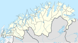
Tranøya is an island in Senja Municipality in Troms og Finnmark county, Norway. It is located in the Solbergfjorden, about 1 kilometre (0.62 mi) south of the large island of Senja. The 1.18-square-kilometre (0.46 sq mi) island is almost totally uninhabited. There is one farm area on the eastern side of the island. The farm is also the site of the historic Tranøy Church. Today the farm is owned by the local government and used as a retirement and assisted living facility. There is also a small museum on the site.[1]
 View of the church on the island | |
 Tranøya Location of the island  Tranøya Tranøya (Norway) | |
| Geography | |
|---|---|
| Location | Troms og Finnmark, Norway |
| Coordinates | 69.1447°N 17.4300°E |
| Area | 1.18 km2 (0.46 sq mi) |
| Length | 1.7 km (1.06 mi) |
| Width | 1 km (0.6 mi) |
| Highest elevation | 32 m (105 ft) |
| Highest point | Kongshågen |
| Administration | |
Norway | |
| County | Troms og Finnmark |
| Municipality | Senja Municipality |
See also
References
- "Tranøy (Senja)" (in Norwegian). Turliv.no.
Текст в блоке "Читать" взят с сайта "Википедия" и доступен по лицензии Creative Commons Attribution-ShareAlike; в отдельных случаях могут действовать дополнительные условия.
Другой контент может иметь иную лицензию. Перед использованием материалов сайта WikiSort.org внимательно изучите правила лицензирования конкретных элементов наполнения сайта.
Другой контент может иметь иную лицензию. Перед использованием материалов сайта WikiSort.org внимательно изучите правила лицензирования конкретных элементов наполнения сайта.
2019-2025
WikiSort.org - проект по пересортировке и дополнению контента Википедии
WikiSort.org - проект по пересортировке и дополнению контента Википедии