geo.wikisort.org - Island
The Togian (or Togean) Islands are an archipelago of 56 islands and many offshore islets, situated in the Gulf of Tomini, off the coast of Central Sulawesi, in Indonesia. The largest islands are Batudaka, Togean, Talatako and Una-Una. There are 59 villages on the islands, with one settled by the Bajau people, more commonly known as the sea gypsies.
Native name: Kepulauan Togean | |
|---|---|
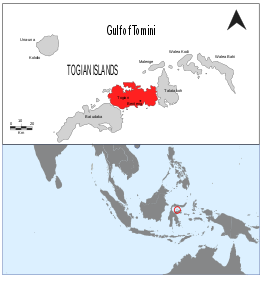 | |
 Map showing the Togian Islands highlighted in red. | |
| Geography | |
| Location | South-east Asia |
| Coordinates | 0°23′30″S 121°57′28″E |
| Total islands | 56 |
| Major islands | Batudaka, Talatako, Togian |
| Administration | |
| Province | Central Sulawesi |
| Demographics | |
| Ethnic groups | Bajau |
| Additional information | |
| Time zone |
|


Administration
The islands are a part of the Tojo Una-Una Regency within Central Sulawesi Province. At the time of the 2010 Census, the Archipelago was divided into four districts (kecamatan). Subsequent to 2010, two additional districts have been created - Batudaka and Talatako. These are tabulated below with their areas and their 2010 and 2020 Census populations,[1] together with the official estimate as at mid 2021. [2] The table also includes the locations of the district administrative centres, the number of villages (rural desa and urban kelurahan) in each district, and its post code.
| Name | Area in km2 | Population Census 2010 | Population Census 2020 | Population Estimate mid 2021 | Administrative centre | No. of villages | Post code |
|---|---|---|---|---|---|---|---|
| Una-Una | 146.16 | 12,455 | 8,236 | 8,315 | Wakai | 11 | 94690 |
| Batudaka | 151.91 | (a) | 5,796 | 5,858 | Molowagu | 9 | 94690 & 94691 |
| Togean | 229.51 | 9,160 | 10,734 | 10,889 | Lebitii | 16 | 94686 |
| Walea Kepulauan (Walea Islands) | 67.60 | 10,065 | 5,568 | 5,608 | Popoliii | 9 | 94694 |
| Walea Besar (Great Walea) | 84.51 | 3,851 | 4,629 | 4,705 | Pasokani | 8 | 94693 |
| Talatako | 83.64 | (b) | 6,471 | 6,597 | Kaliai | 6 | 94692 |
| Total Togean Islands | 763.33 | 35,531 | 41,434 | 41,972 | 59 |
Notes: (a) The 2010 Census population of Batudaka district is included in the figure for Una-Una district, from which it was cut out.
(b) The 2010 Census population of Talatako district is included in the figure for Walea Kepulauan district, from which it was cut out.
Geology and ecology
Formed by volcanic activity, the islands are covered by rainforest and surrounded by coral reef formations, which provide habitat and breeding areas for hawksbill turtle, green turtle and the dugong. The Tonkean macaque is found in the islands' forests. The animals endemic to the islands include the Togian babirusa and the Togian hawk-owl, which is discovered in 1999. The Togian white-eye, another endemic bird species, was described in 2008. Non-venomous jellyfish are also found in Togian Islands, the unique one is jellyfish with little red spots.[3]
National Park
On 2004, the government established a part of Togean Islands as a National Park consists of 292,000 hectares of sea water (includes 132,000 hectares of coral reef which is the largest in Indonesia), 70,000 hectares of land and 10,659 hectares reservation of forests and mangroves.[4]
See also
- Kepulauan Togean National Park
References
- Badan Pusat Statistik, Jakarta, 2021.
- Badan Pusat Statistik, Jakarta, 2022.
- "Tujuh Danau Ubur-Ubur Unik di Indonesia". Retrieved November 5, 2014.
- "Keindahan Bawah Luat Terpendam di Kepulauan Togean". September 25, 2011.
External links
- Togean Islands website for a general source of informations about the Togean Islands
 Togian Islands travel guide from Wikivoyage
- Informative and rare trip report
| Authority control: National libraries |
|---|
This Central Sulawesi location article is a stub. You can help Wikipedia by expanding it. |
На других языках
[de] Togianinseln
Die Togianinseln sind eine Inselgruppe aus etwa 56 Inseln in dem tiefen Einschnitt des Golf von Tomini zwischen dem nördlichen und östlichen Festlandarm von Sulawesi, Indonesien. Sie bilden einen 120 km langen, stark fragmentierten Inselbogen. Auf den verschiedenen Inseln leben insgesamt etwa 40.000 Einwohner in 37 Dörfern. Die Hauptstadt ist Wakai, gelegen an der Nordostküste von Batudaka. Sie befindet sich nur 24 Seemeilen südlich des Äquators bei 00° 25' Süd, 121°52' Ost. Weitere größere Ansiedlungen sind Katupat, Malengeh und Dolong. Die Bevölkerung besteht aus verschiedenen ethnischen Gruppen, den Bobongko, Togiani, Suluan, Bajau und den Bajau-Sama-Seenomaden.- [en] Togian Islands
[es] Islas Togian
Las islas Togian (o Togean) (en indonesio, Pulau Togian) son un grupo de islas de Indonesia oriental, localizadas en el golfo de Tomini, frente a la costa de la parte central de la isla de Célebes. El grupo se compone de 56 islas, siendo las mayores Anau, Batudaka, Bolilanga, Bomba, Kabalutan, Kadidiri, Katupat, Malenge, Milo, Una-Una, Taoleh, Wakai, Walae Bahi y Walea Kodi.[fr] Îles Togian
Les îles Togian, en indonésien Kepulauan Togian, sont un archipel d'Indonésie situé dans le golfe de Tomini et entouré par Sulawesi en direction du nord, de l'ouest et du sud.[it] Isole Togian
Le isole Togian (o Togean) sono un arcipelago comprendente 56 isole e isolette situato nel golfo di Tomini, al largo delle coste del Sulawesi Centrale (Indonesia). Le tre isole maggiori sono Batudaka, Togian e Talatakoh. Sulle isole vi sono in tutto 37 villaggi.[ru] Тогиан (острова)
Тогиан[1], или Черепашьи (индон. Togean) — архипелаг в Индонезии к востоку от острова Сулавеси. Расположен в заливе Томини[en] между сулавесийскими полуостровами Минахаса и Восточным[en]. Состоит из 56 островов, крупнейшими из которых являются Батудака, Тогиан, Талата-Кох и Унауна.Другой контент может иметь иную лицензию. Перед использованием материалов сайта WikiSort.org внимательно изучите правила лицензирования конкретных элементов наполнения сайта.
WikiSort.org - проект по пересортировке и дополнению контента Википедии