 Historic Commissioner’s Mansion
 Scuba off South Caicos Island
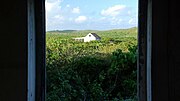 House on South Caicos Island
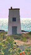 South Caicos Light House
 South Caicos Flamingos
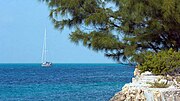 Sailing off South Caicos
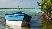 The Shore of South Caicos Island
 South Caicos Island’s Reefs
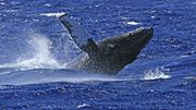 Humpback whale cresting off South Caicos Island
geo.wikisort.org - Island
South Caicos is the seventh-largest island in the Turks and Caicos archipelago, with a land area of 21.2 square kilometres (8.2 square miles). South Caicos is known for excellent fishing, both deep-sea and bone fishing, and scuba diving. South Caicos was formerly a salt exporter, the island still hosts a network of salt pans as a reminder of the industry. Today, the island's main income is derived from small-scale commercial fishing.
 The village of Cockburn Harbour on South Caicos | |
 South Caicos The location of South Caicos within the Turks and Caicos Islands  South Caicos South Caicos (Caribbean) | |
| Geography | |
|---|---|
| Location | Atlantic Ocean |
| Coordinates | 21°30′34″N 71°31′04″W |
| Archipelago | Lucayan Archipelago |
| Administration | |
United Kingdom | |
| British Overseas Territory | Turks and Caicos Islands |
| Demographics | |
| Population | 1,139 (2012)[1] |
| Additional information | |
| Time zone |
|
| • Summer (DST) |
|
| ISO code | TC |
The School for Field Studies, a global nonprofit, accredited by the University of Minnesota-Twin Cities,[2] has established a well-regarded Center for Marine Resource Studies in Cockburn Harbour.[3] The Centre's research focuses on marine ecology and natural resource management.[4] The island hosts an Annual South Caicos Regatta, a large celebration that features parties, boat races, and other games.[5] Though there is some real estate development, tourism is, currently, virtually nonexistent on South Caicos.
Geography
The island is 22 mi (35 km) west of Grand Turk.[6] Bell Sound is at the western side of the island, providing an important fishing site.[7] Together with uninhabited East Caicos and a number of smaller islands, it forms the South Caicos and East Caicos District, with a total area of 136.8 square kilometres (53 square miles). All islands in the east and south of Caicos Bank belong to this district, except French Cay, which belongs to Providenciales and West Caicos. The larger ones of these islands are Hog Cay (7.9 km2 (3.1 sq mi)), McCartney Cay (3.5 km2 (1.4 sq mi)), Little Ambergris Cay (6.6 km2 (2.5 sq mi)), Big Ambergris Cay (4.3 km2 (1.7 sq mi)), and Long Cay (immediately south of South Caicos, 1.0 km2 (0.39 sq mi)). Between South Cacios and the Amgergris Cays are the Six Hill Cays (0.0914 km2 (0.0353 sq mi)) and the Fish Cays (0.1044 km2 (0.0403 sq mi)). South of the Ambergris Cays are Bush Cay (0.0814 km2 (0.0314 sq mi)), Pear Cay (0.0138 km2 (0.0053 sq mi)), Shot Cay (0.0004 km2 (0.00015 sq mi)), White Cay (0.0343 km2 (0.0132 sq mi)), South Rock, Whale Breaker, and Swimmer Rock (submerged), and southwest, West Sand Spit (submerged). The cays from Bush Cay to White Cay are the Seal Cays. South Rock is submerged, with a depth of less than 1.8 m (5.9 ft) above it.
History
South Caicos may have been the second island sighted by Christopher Columbus. The original inhabitants of the island were Taíno and Lucayan Indians. In addition to a variety of archaeological treasures, they left behind the names of the islands in the form of the indigenous "Turk's head" cactus and the Lucayan term “caya hico” meaning string of islands named Caicos. The Lucayans disappeared roughly 30 years after his arrival, leaving the island sparsely populated and the salt industry booming.
The French and Spanish briefly captured the island in 1706 during which time it became a pirate haven.[citation needed] Until a fungus outbreak killed them off, sea-sponge farming briefly flourished on the island during the 1930s. The United States built an anti-submarine base on South Caicos in 1944, along with the first airstrip in the archipelago. During the 1950s a Canadian businessman attempted to start a conch shell export business on the island. In 1959 the U.S. returned to South Caicos when the Coast Guard constructed a LORAN (low-frequency radio signal navigation) station on the island. Today the island attracts tourists drawn to its unspoiled coral reefs.[8]
Population
The population of South Caicos Island was estimated at 1,139 in 2012.[1]
Villages on South Caicos
- Out North
- The Flat
- Highlands
Cockburn Harbour
Named in 1840 after an official visit by a Governor of the Bahamas – Sir Francis Cockburn – Cockburn Harbour is the largest settlement on South Caicos Island and is home to some 900 year-round residents. Cockburn Harbour is known for having the best natural harbour in the Turks and Caicos Islands. Until the 1960s it was an important centre of regional trade and a major exporter of salt. Today its main industry is small-scale fishing focused on conch and spiny lobster exports. A variety of historic structures, including the Queen's Parade Grounds, an old Wesleyan Church, the 18th-century Commissioner's House, the old saltworks and the boiling hole that fed them can be found in the town.[9] The abandoned salt pans just outside town have become the home of a number of bird species including large flocks of flamingos.
Education
Marjorie Basden High School is in South Caicos.[10]
Images


References
- "Population 2012 census". Government of Turks and Caicos. Retrieved 15 May 2021.
- "About SFS". The School for Field Studies. Archived from the original on 12 March 2016.
- "Turks & Caicos Islands". The School for Field Studies. Retrieved 10 January 2019.
- "South Caicos, Turks and Caicos Islands". TCInvest. Retrieved 10 February 2011.
- "Ewing crowned Miss Regatta at South Caicos event". FP Turks and Caicos. 4 June 2010. Retrieved 10 February 2011.
- "Participating States - Turks & Caicos Islands". CDERA. Archived from the original on 3 June 2013. Retrieved 10 April 2016.
- Wells, S.M. (1988). Coral Reefs of the World. Vol. 1: Atlantic and Eastern Pacific. UNEP/IUCN. pp. 304–5. ISBN 2880329434. OCLC 916128569.
- Borsuk, Kathy (March 2011). "A Fighting Chance". Times of the Islands. Retrieved 10 January 2019.
- "Cockburn Harbour". Encyclopaedia Britannica. Retrieved 10 January 2019.
- "Marjorie Basden High School gets new principal". Turks and Caicos Weekly News. 2018-08-06. Retrieved 2020-01-19.
External links
На других языках
[de] South Caicos
South Caicos ist die südöstlichste Insel der Caicos-Inseln und gehört zum Britischen Überseegebiet der Turks- und Caicosinseln.- [en] South Caicos
[es] Caicos del Sur
Caicos del Sur (o South Caicos) es la séptima isla más grande de las Islas Turcas y Caicos, con una superficie de 21,2 km². La población se estimó en 1.579 para el año 2006. Junto con las deshabitadas Caicos oriental y una serie de islas más pequeñas, constituyen el distrito de Caicos del Sur y del Este , con una superficie total de 136,8 km². Todas las islas en el este y el sur del Banco Caicos pertenecen a este distrito, con excepción de Cayo Francés, que pertenece a Providenciales y Caicos del Oeste. Entre las más grandes de estas islas están el Cayo McCartney (11,4 km ²), el Cayo Pequeño Ámbar gris (6,6 km ²), el Gran Cayo Ámbar gris (4,3 km ²), y Cayo Largo (1,0 km ²).[fr] South Caicos
South Caicos (ou Caïcos du Sud) est une île de l'archipel des Caïcos, dépendantes du territoire des Îles Turques-et-Caïques.Текст в блоке "Читать" взят с сайта "Википедия" и доступен по лицензии Creative Commons Attribution-ShareAlike; в отдельных случаях могут действовать дополнительные условия.
Другой контент может иметь иную лицензию. Перед использованием материалов сайта WikiSort.org внимательно изучите правила лицензирования конкретных элементов наполнения сайта.
Другой контент может иметь иную лицензию. Перед использованием материалов сайта WikiSort.org внимательно изучите правила лицензирования конкретных элементов наполнения сайта.
2019-2025
WikiSort.org - проект по пересортировке и дополнению контента Википедии
WikiSort.org - проект по пересортировке и дополнению контента Википедии