geo.wikisort.org - Island
Sherbro Island is in the Atlantic Ocean, and is included within Bonthe District, Southern Province, Sierra Leone. The island is separated from the African mainland by the Sherbro River in the north and Sherbro Strait in the east. It is 32 miles (51 km) long and up to 15 miles (24 km) wide, covering an area of approximately 230 square miles (600 km2). The western extremity is Cape St. Ann. Bonthe, on the eastern end, is the chief port and commercial centre.
This article needs additional citations for verification. (May 2014) |

Sherbro Island, Sierra Leone | |
|---|---|
| Country | Sierra Leone |
| Province | Southern Province |
| District | Bonthe District |
| Population (2013 estimate) | |
| • Total | 28,457 |
| Time zone | UTC±0 (Greenwich Mean Time) |
Historically, this was part of the territory of the historic Sherbro people, who dominated a large area of what is now Sierra Leone. Today they are concentrated in the southern and central part of Moyamba District. They make up by far the largest ethnic group in the island, where the total population is 28,457. The island has more than 65 miles (105 km) of tropical beaches. It has been earmarked by the Ministry for Tourism and Development of Sierra Leone for tourism development.
Economic activities
Swamp-rice cultivation, tourism, and fishing are the main economic activities.
History
Sherbro Island was long inhabited by the Sherbro people, who historically dominated other ethnicities in much of the region on the mainland. The islanders had an economy based on extensive fishing. They also traded by boat with neighboring people in villages along the coast.
In the seventeenth century Portuguese, Spanish, and Dutch explorers and traders came to this area. They traded with the Sherbro and with other tribes up the rivers to the interior. They referred to what is now known as the Sherbro River as the Madrebombo River, which may have referred to "mother drum" in Spanish. Dutch letters dated 1633 refer to the river in a spelling variation as Maderebombo. Other spelling versions included Madrabomba. (See: Navigantium Atque Itinerantium Bibliotheca)
In the seventeenth century, the Royal African Company, chartered as a monopoly in England, began to operate here and on the Guinea Coast as traders. While originally seeking gold, particularly along the Gambia River, by the early eighteenth century the RAC became involved in slave trading, which its monopoly covered.
The RAC established a Company fort known as York Island at Sherbro Island. It was a port for exporting enslaved Africans to the Americas. Thomas Corker, who was from Falmouth, Cornwall, had been working with the RAC for more than a decade when he was appointed agent here in the late seventeenth century. He married the daughter of a Sherbro chief, and their two sons became the patriarchs of a family dynasty of traders and chiefs in the region. Shortly after being reassigned to The Gambia, he died on a business trip to England in 1700, but his descendants in Sierra Leone did well.[1]
After Great Britain abolished the international African slave trade in 1808 in partnership with the United States, it used the former RAC trading fort on Sherbro Island as a base for naval operations against illegal slave traders. Liberated slaves were resettled in the Freetown colony. But for decades more, both Spain and Portugal continued to buy African slaves for their colonies in the Caribbean, and Central and South America.
In 1815 Paul Cuffe, a successful African-American ship maker of Boston, Massachusetts, became interested in resettling free blacks in west Africa. The British had undertaken this at Freetown, Sierra Leone since 1792. There Black Loyalists from Nova Scotia (African Americans freed in the American Revolution) had been joined by Maroons deported from Jamaica, Liberated Africans freed from illegal traders, and some of the ethnic groups in the territory of Sierra Leone who were interested in western culture.[2]
Cuffe believed that skilled American blacks could help develop trade between Sierra Leone and the United States, benefiting both. In 1815, he resettled a group of 88 American freedmen on Sherbro Island. After returning to the US, Cuffe marketed his cargo of goods taken on at Freetown.[2]
Cuffe died in 1817, but the American Colonization Society (ACS), founded in 1820 by both abolitionists and slaveholders, continued the effort to resettle free blacks in Africa. They commissioned a survey of possible areas, including Sherbro Island. They found John Kizell, a Sherbro born locally who had returned after being captured and held in slavery in South Carolina. He gained freedom with the British during the American Revolutionary War and was among 1200 Black Loyalists resettled here in 1792. He led a number of Sherbro people.
The U.S. Congress passed an act on March 3, 1819, authorizing transport of freed blacks to their "motherland". The ACS began to develop a colony in Africa for free American blacks. It later became known as the Republic of Liberia. In this period, most free blacks (and enslaved) in the US were native to the nation; they had family and history there. They wanted to gain equal rights and non-discriminatory treatment in the US.
In 1821, the ship Elizabeth from New York carried 86 free African Americans (including missionary Daniel Coker), as well as three ACS agents, as the first ACS sponsored group to Sherbro Island. Disease and fever quickly killed more than a quarter of the would-be settlers.[3] The survivors relocated in April 1822 to Providence Island at Cape Mesurado in what developed as the nation of present-day Liberia.[3]
In 1861 the British Crown Colony at Freetown acquired Sherbro Island from the Sherbro people, putting it under the jurisdiction of its government. The Sherbro continued to live there. The colonial and later protectorate government administered it until Sierra Leone achieved independence in 1961.
Environment

Sherbro Island is believed to be a breeding ground for green sea turtles as well as leatherback sea turtles.[4] The waters surrounding the island hold some of the biggest tarpon in the world. Records of the sportfishing organisation IGFA have been made by catches from this area.
Population
In May 2013, the Government of Sierra Leone's record of the island's population was 28,457.
References
- Tattersfield, Nigel (1991). The Forgotten Trade: Comprising the Log of the 'Daniel and Henry' of 1700 and Accounts of the Slave Trade From the Minor Ports of England 1698–1725 (1778). London. pp. 309–19.
- Harris, Sheldon H. Paul Cuffee: Black America and the African Return. New York: Simon & Schuster, 1972.
- "Excerpt: 'This Child Will Be Great'". Npr.org. Retrieved 2017-01-21.
- "MTN 54:10-12 Sea Turtle Nesting in Sierra Leone, West Africa". Seaturtle.org. Retrieved 2017-01-21.
External links
- Trenchard, Tommy (22 Jul 2015). "Sierra Leone's layers of history, A past filled with historical memories slowly crumbles away on a forgotten island in Sierra Leone". Al Jazeera Media Network.
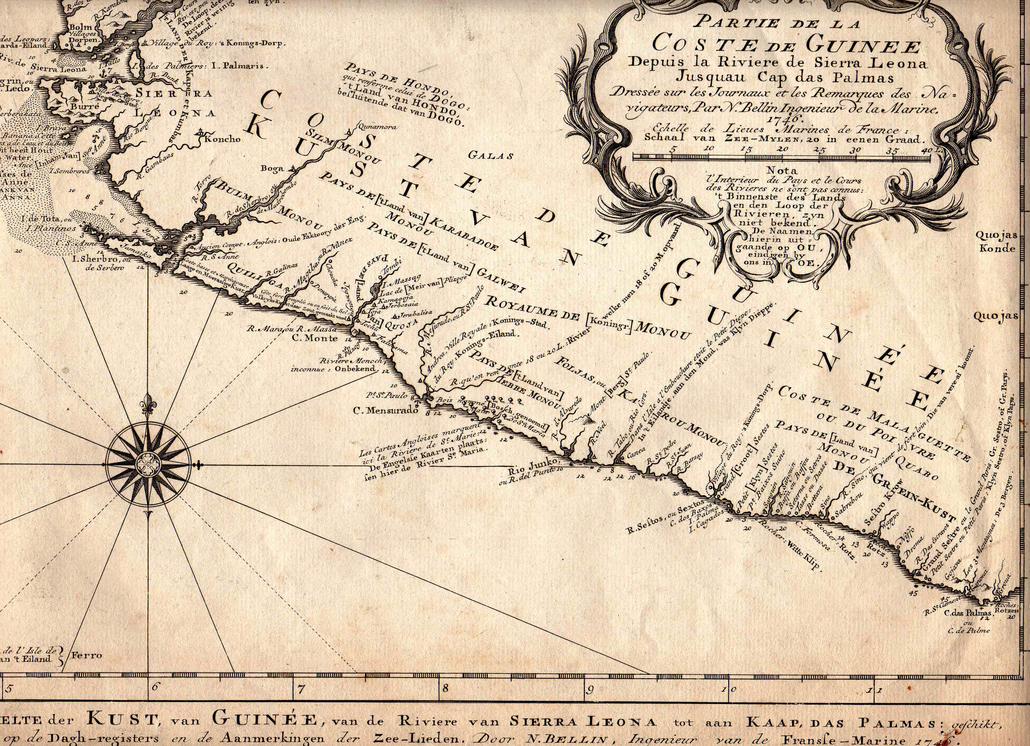
- 1746 map of the Guinea Coast, including Sierra Leone, by N. Bellin. Published in German.
- Navigantium Atque Itinerantium Bibliotheca, Google Books
Authority control | |
|---|---|
| General |
|
| National libraries | |
На других языках
[de] Sherbro (Insel)
Die Insel Sherbro (englisch Sherbro (Island)), auch Bonthe genannt, liegt vor der Küste des westafrikanischen Sierra Leone im Atlantik. Der Hauptort der Insel ist Bonthe mit etwa 9700 Einwohnern am östlichen Ende der Insel[1], das zugleich Hauptort des gleichnamigen Distrikts Bonthe ist.- [en] Sherbro Island
[es] Isla Sherbro
La Isla Sherbro (en inglés: Sherbro Island) es una isla en el océano Atlántico situado en el distrito Bonthe de la Provincia Sur de Sierra Leona. El pueblo Sherbro constituye el mayor grupo étnico de la isla, separada del continente africano por el río Sherbro al norte y el estrecho Sherbro al este.[it] Sherbro
Sherbro (nota anche come isola di Bonthe) è un'isola della Sierra Leone. Si trova di fronte alla parte sudoccidentale della costa del paese.[ru] Шербро (остров)
Шербро[1] (англ. Sherbro Island) — крупный остров в Атлантическом океане. Расположен у побережья Сьерра-Леоне в Западной Африке, в эстуарии рек Сева[en] (Киттам), Джонг[en] (Тая) и Багру (Гбангба), к западу от города Матру[en]. Отделён от материка проливом Шербро[1]. Административно относится к округу Бонте[en] Южной провинции. На восточной оконечности острова расположен крупнейший город, порт и торговый центр округа — Бонте[en][1].Другой контент может иметь иную лицензию. Перед использованием материалов сайта WikiSort.org внимательно изучите правила лицензирования конкретных элементов наполнения сайта.
WikiSort.org - проект по пересортировке и дополнению контента Википедии