geo.wikisort.org - Island
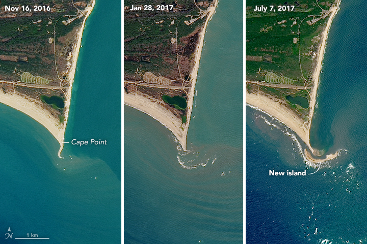
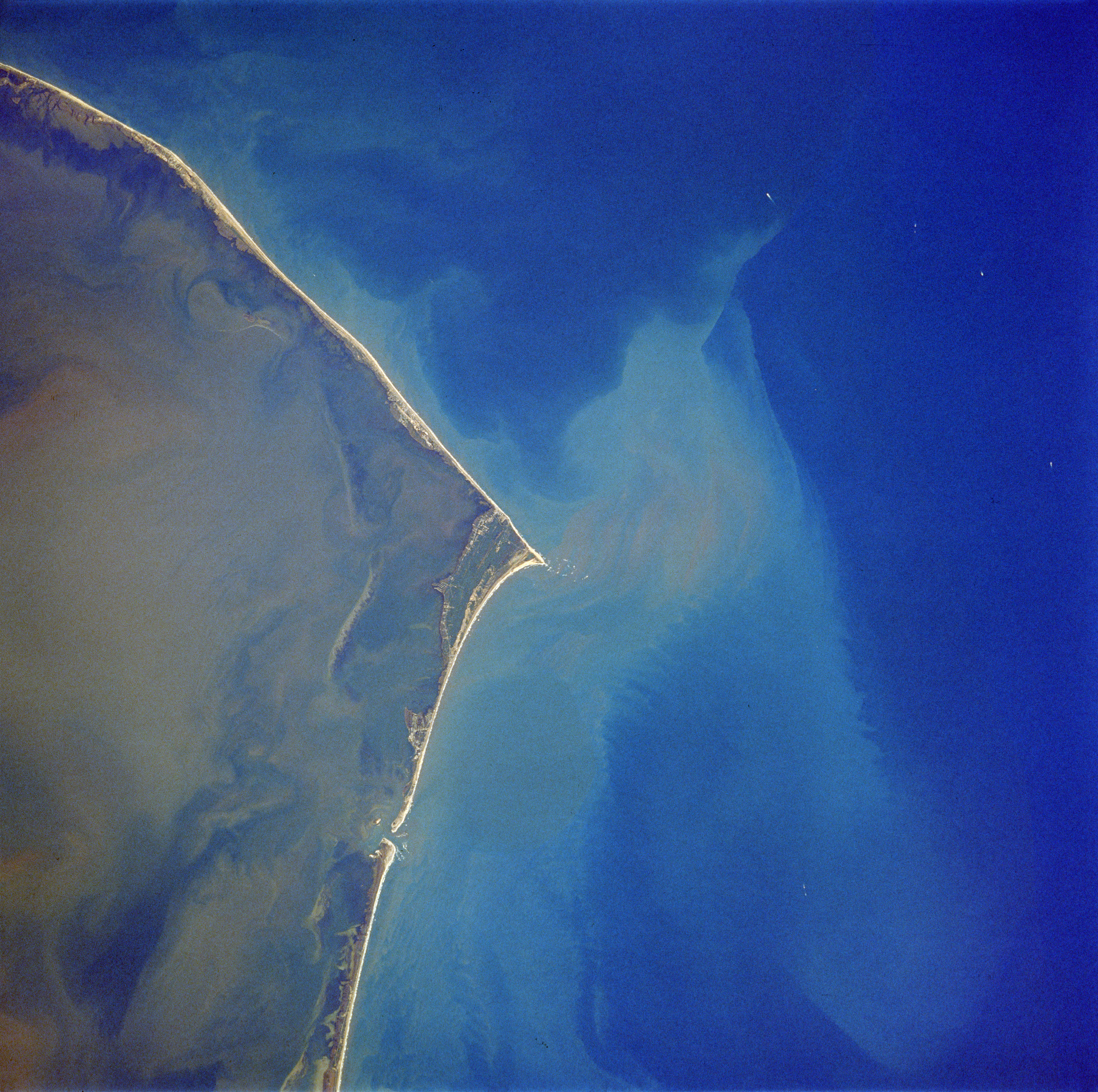
Shelly Island was a sandy island which began forming around April 2017, as a sandbank in the Outer Banks of North Carolina. Located off the tip of Cape Point in Buxton, North Carolina, the island was greatly reduced by the passage of Hurricane Maria. At its greatest extent, the crescent-shaped island measured around one mile long and more than 500 ft (150 m) wide. It was nicknamed Shelly Island by locals because of the vast quantities of shells that were found on the shore. By early 2018, the island had disappeared.
Geography
The island sat a few hundred feet away from Hatteras Island, with water at depth of no more than 5 ft (1.5 m).[1] The surrounding area is referred to as the Graveyard of the Atlantic.[2][3] Small landmasses frequently appear and vanish in this area, but Shelly Island was notable for its size and the speed with which it formed.[4] One explanation for the island's formation was a lack of strong nor'easter storms the previous winter, along with more than typical southwesterly winds, which led to the buildup of additional sand in the area.[5]
As long as the island remained detached, it fell under the jurisdiction of Dare County, North Carolina. If it had grown enough to merge into Hatteras Island, it would potentially have come under federal jurisdiction and become part of Cape Hatteras National Seashore.[1] In September 2017, businessman Ken Barlow filed a quitclaim deed against the island, seeking ownership of the land.[6] At that time, experts cautioned that the island would likely not last a full year as a separate landform.[4]
As of September 18, 2017, Shelly Island was connected to land at low tide, with water continuing to separate the island from the mainland at high tide.[7] Over the next few weeks, the channel between the island and the mainland began to deepen again.[6]
In late September 2017, after the passage of Hurricane Maria, North Carolina estimated that the island had been reduced by 70%, with the portion closest to the mainland reattaching, and a small oval of land remaining unattached offshore.[6]
Photographs from Landsat 8 taken on February 16, 2018 revealed that the island had completely disappeared and that what remained of the island had merged with Cape Point, North Carolina.[8]
Ownership claim
Ken Barlow, a businessman and resident of Mechanicsville, Virginia, alleged that he was the rightful owner of the island by way of a quitclaim deed he executed in the Dare County Register of Deeds office on August 7, 2017.[9] Barlow reasserted his claim in early 2018 despite the apparent disappearance of the island.[10]
References
- Price, Mark. "So who owns that new island off North Carolina? It's likely not who you think", Charlotte Observer. July 7, 2017.
- Janice Williams (June 30, 2017). "How Are Islands Formed? New Mysterious Land Mass Appears off North Carolina". Newsweek. Retrieved July 2, 2017.
- "Shelly Island: The new beach off North Carolina's Outer Banks". Retrieved September 18, 2018.
- Welch, Craig. "New Island Appears Off Coast of North Carolina in Outer Banks", National Geographic. June 27, 2017.
- Kozak, Catherine. While a new island grew, southern Hatteras was shrinking. The Outer Banks Voice. November 1, 2017.
- Price, Mark. "NC's mysterious new island does something mysterious again", Charlotte Observer. October 1, 2017.
- EndPlay (September 18, 2017). "No more Shelly Island? Outer Banks tract now connected to land". WSOC. Retrieved September 18, 2017.
- "Shelly Island is no longer an island, NASA says". WWAY. March 9, 2018. Retrieved March 14, 2018.
- With Hurricane Irma looming, thinking businessman files claim on NC's new island Retrieved March 15, 2018.
- Can you own a sunken island? Retrieved March 15, 2018.
На других языках
- [en] Shelly Island
[es] Shelly Island
Shelly Island es una isla que se formó a partir de abril de 2017 como banco de arena en el área conocida como "el Cementerio del Atlántico",[1][2] cerca de la corriente del Labrador y la del Golfo.[fr] Shelly Island
Shelly Island était une île de sable qui a commencé à se former vers avril 2017 dans les Outer Banks de Caroline du Nord. Située au large de la pointe de Cape Point à Buxton, l'île a mesuré jusqu'à 1,6 kilomètre de long sur 150 mètres de large. Les habitants lui donnent le nom de Shelly Island en raison des grandes quantités de coquillages qu'on trouve sur ses rives. Le passage de l'ouragan Maria ampute sa surface de 70% et début 2018, l'île a disparu.Другой контент может иметь иную лицензию. Перед использованием материалов сайта WikiSort.org внимательно изучите правила лицензирования конкретных элементов наполнения сайта.
WikiSort.org - проект по пересортировке и дополнению контента Википедии