geo.wikisort.org - Island
Rødøya is an island in the municipality of Rødøy in Nordland county, Norway. The 8.5-square-kilometre (3.3 sq mi) island is located just west of the mouth of the Tjongsfjorden, north of the island of Gjerdøya, and west of the mainland. There are ferry connections from the village of Rødøy to the village of Jektvika on the mainland and to the nearby island of Gjerdøya. Rødøy Church is located in the village of Rødøy on the south side of the island. The island had 150 residents in 2017.[1]
 | |
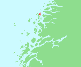 | |
 Rødøya Location of the island  Rødøya Rødøya (Norway) | |
| Geography | |
|---|---|
| Location | Nordland, Norway |
| Coordinates | 66.6866°N 13.0769°E |
| Area | 8.2 km2 (3.2 sq mi) |
| Length | 5.2 km (3.23 mi) |
| Width | 2.5 km (1.55 mi) |
| Highest elevation | 443 m (1453 ft) |
| Highest point | Rødøyløva |
| Administration | |
Norway | |
| County | Nordland |
| Municipality | Meløy Municipality |
| Demographics | |
| Population | 150 (2017) |
See also
References
- Thorsnæs, Geir, ed. (2017-07-14). "Rødøya – øy i Rødøy". Store norske leksikon (in Norwegian). Kunnskapsforlaget. Retrieved 2019-02-02.
This article about an island in Nordland is a stub. You can help Wikipedia by expanding it. |
Текст в блоке "Читать" взят с сайта "Википедия" и доступен по лицензии Creative Commons Attribution-ShareAlike; в отдельных случаях могут действовать дополнительные условия.
Другой контент может иметь иную лицензию. Перед использованием материалов сайта WikiSort.org внимательно изучите правила лицензирования конкретных элементов наполнения сайта.
Другой контент может иметь иную лицензию. Перед использованием материалов сайта WikiSort.org внимательно изучите правила лицензирования конкретных элементов наполнения сайта.
2019-2026
WikiSort.org - проект по пересортировке и дополнению контента Википедии
WikiSort.org - проект по пересортировке и дополнению контента Википедии