geo.wikisort.org - Island
Roosevelt Island is the second largest ice rise of Antarctica and world-wide, after Berkner Island. Despite its name, it is not an island, since the bedrock below the ice at its highest part is below sea level. It is about 130 km (81 mi) long in a NW-SE direction, 65 km (40 mi) wide and about 7,500 km2 (2,896 sq mi) in area, lying under the eastern part of the Ross Ice Shelf of Antarctica. Its central ridge rises to about 550 m (1,804 ft) above sea level, but this and all other elevations of the ice rise are completely covered by ice, so that it is invisible at ground level.
This article needs additional citations for verification. (September 2010) |
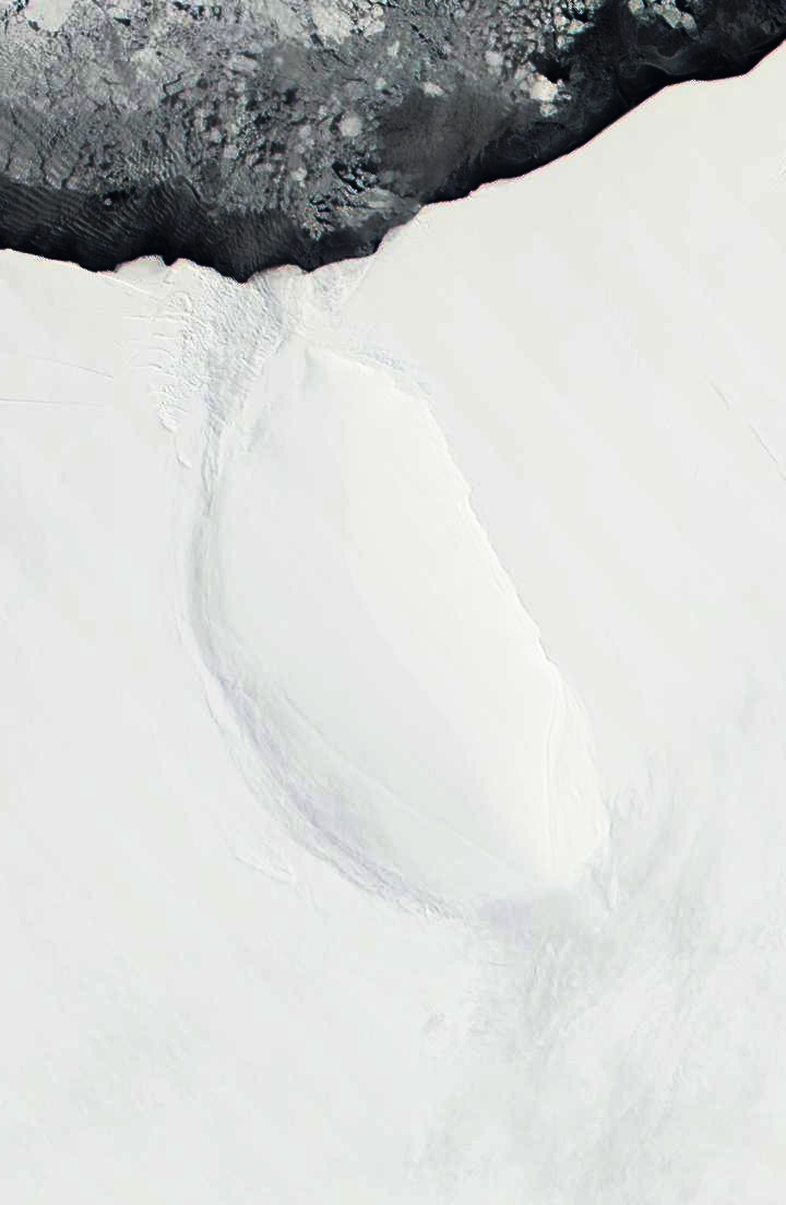 November 2001 satellite image of Roosevelt Island | |
 Roosevelt Roosevelt Island | |
| Geography | |
|---|---|
| Location | Antarctica |
| Coordinates | 79°25′S 162°00′W |
| Area | 7,500 km2 (2,900 sq mi) |
| Area rank | 91st |
| Length | 130 km (81 mi) |
| Width | 65 km (40.4 mi) |
| Highest elevation | 550 m (1800 ft) |
| Administration | |
| Administered under the Antarctic Treaty System | |
| Demographics | |
| Population | Data not available |
| Additional information | |
| Claimed by New Zealand as part of the Ross Dependency. | |
Examination of how the ice flows above it establishes the existence and extent of the ice rise.[1] [2] Radar surveying carried out between 1995 and 2013 showed that the Raymond Effect was operating beneath the ice divide.[2][3] The ice rise has become a focus of the Roosevelt Island Climate Evolution (RICE) research [4] using ice coring.[5]
Rear Admiral Richard E. Byrd named it in 1934 after US President Franklin D. Roosevelt. Byrd was the leader of the expedition that discovered the ice rise.[6] Roosevelt Island lies within the boundaries of the Ross Dependency, New Zealand's Antarctic claim.
See also
- Composite Antarctic Gazetteer
- SCAR
- Territorial claims in Antarctica
References
- Michon Scott (23 April 2007). "Something under the ice is moving". NASA's Earth Observatory. Retrieved 23 September 2010.
- Conway, H.; et al. (1999). "Past and Future Grounding-Line Retreat of the West Antarctic Ice Sheet". Science. 286 (5438): 280–283. doi:10.1126/science.286.5438.280. PMID 10514369.
- Kingslake, J.; Hindmarsh, R.C.A; Aðalgeirsdóttir, G.; et al. (2014). "Full-depth englacial vertical ice-sheet velocities measured using phase-sensitive radar". Journal of Geophysical Research. 119 (12): 2604–2618. Bibcode:2014JGRF..119.2604K. doi:10.1002/2014JF003275. S2CID 129824379.
- Bertler, N.A.N.; Conway, H.; Dahl-Jensen, D.; Emanuelsson, D.B.; Winstrup, M.; et al. (2018). "The Ross Sea Dipole - Temperature, Snow Accumulation and Sea Ice Variability in the Ross Sea Region, Antarctica, over the Past 2,700 Years". Climate of the Past. 14 (2): 193–214. Bibcode:2018CliPa..14..193B. doi:10.5194/cp-14-193-2018.
-
Talalay, Pavel G. (16 March 2016). "9: Cable-Suspended Electromechanical Drills with Bottom-Hole Circulation". Mechanical Ice Drilling Technology. Springer Geophysics. Singapore: Springer (published 2016). p. 236. ISBN 9789811005602. Retrieved 10 November 2016.
Roosevelt Island is a coastal ice rise [...] where intermediate-depth ice coring was carried out as part of the Roosevelt Island Climate Evolution (RICE) international project led by New Zealand.
- Peter Rejcek (3 September 2010). "Roosevelt Island: U.S., Kiwi scientists team up to look at stability of ice shelf". Antarctic Sun. Retrieved 23 September 2010.
На других языках
[de] Roosevelt-Insel
Die Roosevelt-Insel (engl. Roosevelt Island, auch Roosevelt Ice Rise) ist eine Eiskuppel[1][2][3] in der Antarktis. Sie liegt im Ross-Schelfeis, dem südlichen, permanent gefrorenen Teil des Rossmeeres und ist vollständig vergletschert. Ihre Nordspitze ist nur fünf Kilometer von der früheren Bucht der Wale (Schelfeisabbruchkante) entfernt, wo die US-Stationen Little America standen.[4] Die Roosevelt-Insel hat eine Fläche von etwa 7500 km² (mehr als doppelt so groß wie Mallorca). Das Eis über dem zentralen Bergkamm erreicht eine maximale Höhe von 550 Metern.[5] Entgegen ihrem Namen ist die Roosevelt-Insel keine Insel, da das Land etwa 200 Meter unter dem Meeresspiegel liegt,[6] sondern nach der Berkner-Insel die zweitgrößte Eiskuppel der Erde.- [en] Roosevelt Island, Antarctica
[es] Isla Roosevelt
La isla Roosevelt (79°25′S 162°00′O) es una isla cubierta por el hielo, aproximadamente de 130 km de largo en la dirección NW-SE por 65 km de ancho, y unos 7500 km² de área, que está en la parte este del barrera de hielo de Ross sobre el mar de Ross, frente a la costa Shirase en la Antártida. Su parte central se eleva unos 550 msnm.[fr] Île Roosevelt (Antarctique)
L'île Roosevelt est une île de l'Antarctique. Elle a été nommée ainsi par l'amiral américain Richard E. Byrd en 1934 en l'honneur du président des États-Unis Franklin D. Roosevelt[1].[it] Isola Roosevelt (Antartide)
L'Isola Roosevelt (in inglese: Roosevelt Island) è un'isola coperta dai ghiacci, lunga circa 130 km in direzione NW-SE, larga 65 km e con una superficie di circa 7.910 km², fatto che la rende la 91ª isola per superficie nel mondo.[ru] Рузвельт (остров, Антарктида)
Ру́звельт[1] (англ. Roosevelt Island) — остров или возвышенность[2] в Южном океане. Хотя остров попадает под действия Договора об Антарктике, он входит в так называемую Территорию Росса, на которую претендует Новая Зеландия.Другой контент может иметь иную лицензию. Перед использованием материалов сайта WikiSort.org внимательно изучите правила лицензирования конкретных элементов наполнения сайта.
WikiSort.org - проект по пересортировке и дополнению контента Википедии