geo.wikisort.org - Island
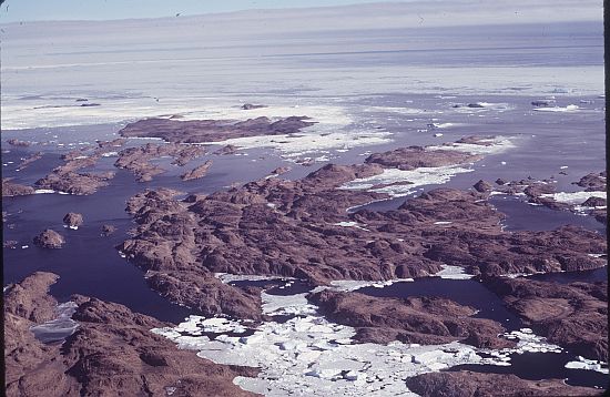
The Rauer Islands (68°51′S 77°50′E) are a group of rocky coastal islands which lie between Sorsdal Glacier Tongue and Ranvik Bay, in the southeast part of Prydz Bay. Discovered and roughly charted in February 1935 by a Norwegian expedition under Captain Klarius Mikkelsen (see Caroline Mikkelsen). He named them Rauer, probably after the island lying in Oslofjorden opposite Tønsberg, Norway.
See also
- List of antarctic and sub-antarctic islands
![]() This article incorporates public domain material from the United States Geological Survey document: "Rauer Islands". (content from the Geographic Names Information System)
This article incorporates public domain material from the United States Geological Survey document: "Rauer Islands". (content from the Geographic Names Information System)
Authority control | |
|---|---|
| General |
|
| National libraries | |
This Princess Elizabeth Land location article is a stub. You can help Wikipedia by expanding it. |
На других языках
[de] Rauer-Inseln
Die Rauer-Inseln (in Australien Rauer Group) sind eine Gruppe felsiger Inseln vor der Ingrid-Christensen-Küste des ostantarktischen Prinzessin-Elisabeth-Lands. Im südöstlichen Teil der Prydz Bay liegen sie zwischen der Zunge des Sørsdal-Gletschers und der Bucht Ranvik. Größte Insel der Gruppe ist mit einer Länge von 5 km Filla Island.- [en] Rauer Islands
Текст в блоке "Читать" взят с сайта "Википедия" и доступен по лицензии Creative Commons Attribution-ShareAlike; в отдельных случаях могут действовать дополнительные условия.
Другой контент может иметь иную лицензию. Перед использованием материалов сайта WikiSort.org внимательно изучите правила лицензирования конкретных элементов наполнения сайта.
Другой контент может иметь иную лицензию. Перед использованием материалов сайта WikiSort.org внимательно изучите правила лицензирования конкретных элементов наполнения сайта.
2019-2026
WikiSort.org - проект по пересортировке и дополнению контента Википедии
WikiSort.org - проект по пересортировке и дополнению контента Википедии