geo.wikisort.org - Island
Poochakkal is part of a small island consisting Arookutty, Panavally, Thycattusserry and Pallippuram Panchayaths close to the Kerala Backwaters in Kerala, India. Until the 2006 Kerala Assembly Elections, Poochakkal was part of the Cherthala LAC. After delimitation from the 2011 elections, it became a part of Aroor LAC.
This article does not cite any sources. (January 2015) |
Poochakkal Town
പൂച്ചാക്കൽ പട്ടണം | |
|---|---|
Town | |
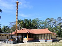
 View of Panchara Manal and Temple below | |
 Poochakkal Town Location in Kerala, India  Poochakkal Town Poochakkal Town (India) | |
| Coordinates: 9.7951595°N 76.3545084°E | |
| Country | India |
| State | Kerala |
| District | Alappuzha |
| Government | |
| • Body | Town area Spread in Two Panchayats Panavally and Thycattuserry |
| Languages | |
| • Official | Malayalam, English |
| Time zone | UTC+5:30 (IST) |
| PIN | 688526 |
| Telephone code | 0478 |
| Vehicle registration | KL-32 |
| Nearest city | Ernakulam |
| Lok Sabha constituency | Alappuzha |
| Vidhan Sabha constituency | Aroor |
| Civic agency | Spread in Two Panchayats Panavally and Thycattuserry |
Location
Poochakkal is located about 2 miles (3.22 km) from Vaduthala(Arookutty), 8 miles (14 km) from Cherthala, about 5 miles (8 km) from Vaikom, 12 miles (20 km) from Vytilla Hub and 15 miles (25 km) from Ernakulam.
Economy
The economy was based on a water transportation system. Its water canal connects the eastern and western parts of Vembanadu Lake. Now it is directly connected to NH47 at two places by new road bridges at Aroor and Thuravoor. Also new bridge is under construction connecting to Vaikom.
Notable people

- Saiju Kurup, Indian actor
Location
References
Другой контент может иметь иную лицензию. Перед использованием материалов сайта WikiSort.org внимательно изучите правила лицензирования конкретных элементов наполнения сайта.
WikiSort.org - проект по пересортировке и дополнению контента Википедии