geo.wikisort.org - Island
Pitt Island is an island located within the traditional territory of the Gitxaala Nation on the north coast of British Columbia, Canada.[1]
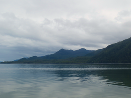 Northern End of Pitt Island as seen from Grenville Channel | |
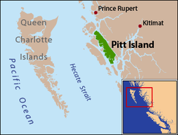 Pitt Island is located between Banks Island and the mainland. | |
| Geography | |
|---|---|
| Coordinates | 53°30′00″N 129°47′00″W |
| Area | 1,368 km2 (528 sq mi) |
| Length | 90 km (56 mi) |
| Width | 8 km (5 mi) |
| Highest elevation | 962 m (3156 ft) |
| Administration | |
Canada | |
| Province | British Columbia |
Pitt island is located between Banks Island, across Grenville Channel (part of the Inside Passage) from the mainland, and is separated from Banks Island by Principe Channel.[2] The island has an area of 1,368 square kilometres (528 sq mi), is 90 kilometres (56 mi) long, and ranges from 8 to 23 kilometres (5.0 to 14.3 mi) wide. Its highest point is at 962 metres (3,156 ft).
Pitt Island is the only island in British Columbia known to host a resident population of Moose[3]
Features
- Anchor Mountain[4]
- Captain Cove[5]
- Holmes Lake[6]
- Hevenor Inlet[7]
- Newcombe Harbour[8]
- Pa-aat River[9]
- Port Stevens[10]
- Monckton Inlet[11]
- Mount Hulke[12]
- Mount Patterson[13]
- Mount Frank[14]
- Mount Saunders[15]
- Mount Shields[16]
- Wyndham Lake[17]
- Red Bluff Lake[18]
Protected Areas
- Union Passage Marine Provincial Park[19]
- Maxtaktsm'Aa/Union Passage Conservancy[20]
- Monckton Nii Luutiksm Conservancy[21]
- Pa-aat Conservancy[22]
References
Wikimedia Commons has media related to Pitt Island (British Columbia).
- Iain McKechnie. Archaeological Research in Southern Gitxaała Territory, Pitt and Banks Islands, August 2009 (PDF) (Report). University of British Columbia. Retrieved 2020-06-22.
- "Pitt Island". BC Geographical Names.
- Price Michael H, Darimont Chris T, Winchester Neville N, Paquet Paul C (2005). "Facts from faeces: prey remains in Wolf, Canis lupus, faeces revise occurrence records for mammals of British Columbia's coastal archipelago". Canadian Field-Naturalist. 119 (2): 192–196. Retrieved 2020-06-22.
- "Anchor Mountain". BC Geographical Names.
- "Captain Cove". BC Geographical Names.
- "Holmes Lake". BC Geographical Names.
- "Hevenor Inlet". BC Geographical Names.
- "Newcombe Harbour". BC Geographical Names.
- "Pa-aat River". BC Geographical Names.
- "Port Stevens". BC Geographical Names.
- "Monckton Inlet". BC Geographical Names.
- "Mount Hulke". BC Geographical Names.
- "Mount Patterson". BC Geographical Names.
- "Mount Frank". BC Geographical Names.
- "Mount Saunders". BC Geographical Names.
- "Mount Shields". BC Geographical Names.
- "Wyndham Lake". BC Geographical Names.
- "Red Bluff Lake". BC Geographical Names.
- "Union Passage Marine Park". BC Geographical Names.
- "Maxtaktsm'Aa/Union Passage Conservancy". BC Geographical Names.
- "Monckton Nii Luutiksm Conservancy". BC Geographical Names.
- "Pa-aat Conservancy". BC Geographical Names.
На других языках
[de] Pitt Island (British Columbia)
Pitt Island ist eine Insel vor der nordwestlichen Küste der kanadischen Provinz British Columbia und gehört zum North Coast Regional District. Die Insel liegt in der Hecate-Straße zwischen dem Festland und Banks Island. Die Insel ist die fünftgrößte kanadische Pazifikinsel, mit einer Küstenlänge von 465 km ist sie rund 90 km lang sowie zwischen 8 und 23 km breit und hat eine Gesamtfläche von 1368 km².[1] Der höchste Punkt der Insel ist der Hevenor Peak mit einer Höhe von 1099 Metern.[2]- [en] Pitt Island (Canada)
[es] Isla Pitt (Canadá)
La isla Pitt es una isla de la Columbia Británica, Canadá, localizada en el estrecho de Hécate, a través del canal de Greenville, es parte del Paso Interior del continente. Es el único establecimiento de las Primeras Naciones de Canadá, del pueblo Chino Hat, sobre la costa occidental. La actividad económica principal es la explotación de los recursos naturales, la extracción minera de magnesita y hierro, y la industria maderera.[it] Isola Pitt
L'isola Pitt è un'isola della Columbia Britannica in Canada.[ru] Питт (остров, Британская Колумбия)
Питт (англ. Pitt Island) — остров близ северо-западного побережья Британской Колумбии, пятый по величине остров среди Тихоокеанских островов Канады.Текст в блоке "Читать" взят с сайта "Википедия" и доступен по лицензии Creative Commons Attribution-ShareAlike; в отдельных случаях могут действовать дополнительные условия.
Другой контент может иметь иную лицензию. Перед использованием материалов сайта WikiSort.org внимательно изучите правила лицензирования конкретных элементов наполнения сайта.
Другой контент может иметь иную лицензию. Перед использованием материалов сайта WikiSort.org внимательно изучите правила лицензирования конкретных элементов наполнения сайта.
2019-2026
WikiSort.org - проект по пересортировке и дополнению контента Википедии
WikiSort.org - проект по пересортировке и дополнению контента Википедии