geo.wikisort.org - Island
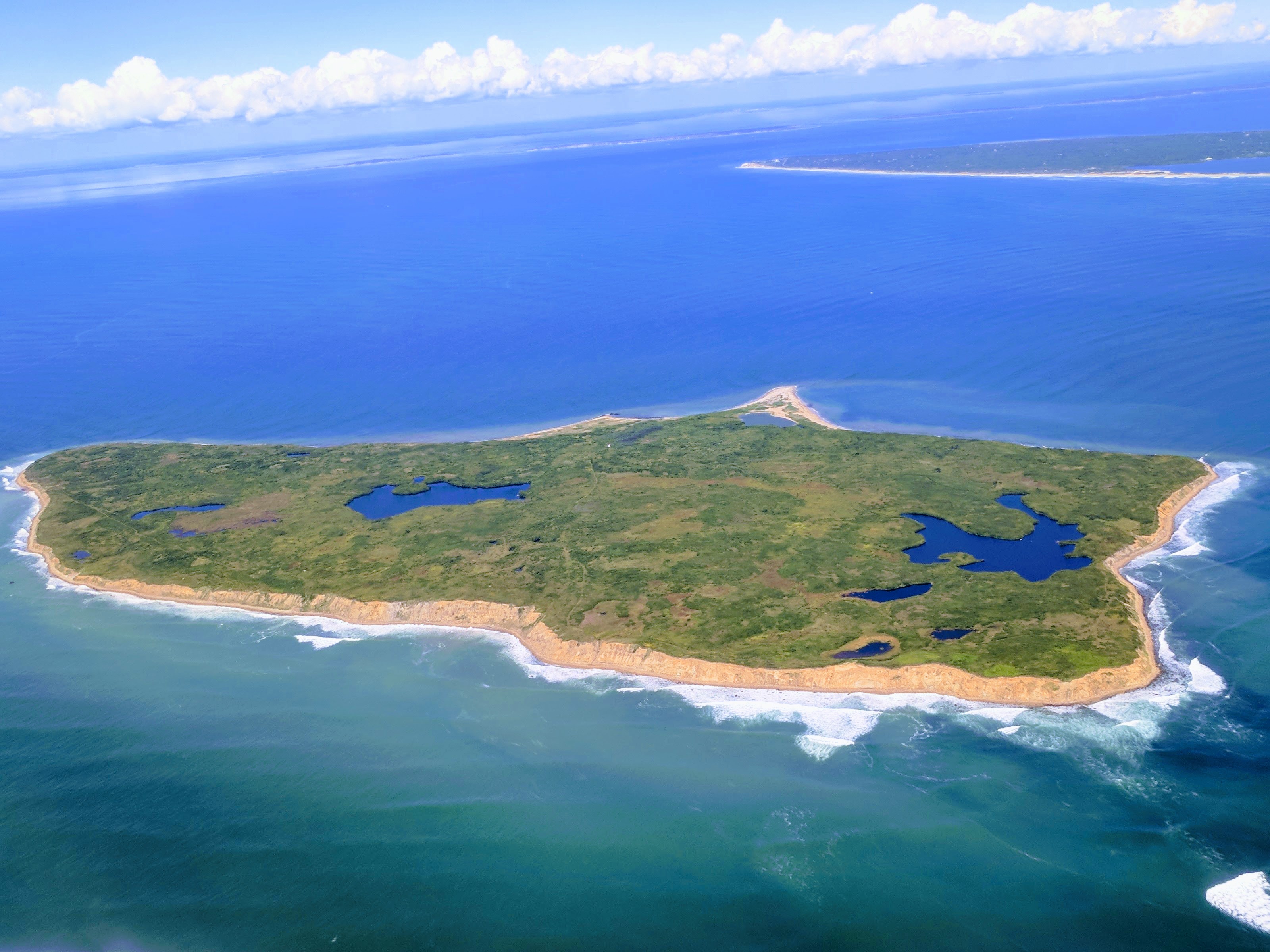
Nomans Land (Wampanoag: Cappoaquit;[1] also mapped "No Man's Land,"[2] "No Mans Land,"[3] or "No Man's island"),[4] is an uninhabited island 612 acres (248 ha) in size, located in the town of Chilmark, Dukes County, Massachusetts.[5] It is situated about 3 miles (4.8 km) off the southwest corner of the island of Martha's Vineyard.
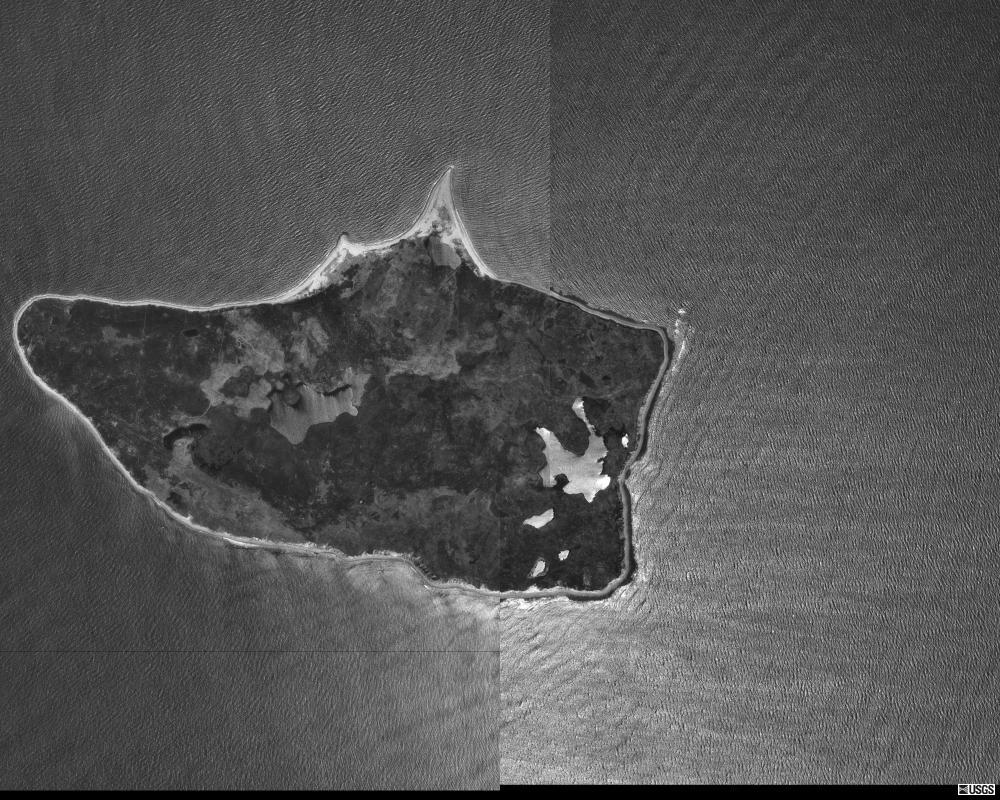
The island was used by the United States Navy as a practice bombing range from 1943 to 1996. In 1998, the Navy transferred the island to the United States Fish and Wildlife Service for use as an unstaffed wildlife refuge, which now forms Nomans Land Island National Wildlife Refuge.[4] Due to safety risks from unexploded ordnance and its value as a wildlife habitat, the island is closed to all public use.[6]
History

In 1602, during the British ship Concord's exploration of Cape Cod, Captain Bartholomew Gosnold named Nomans Land "Martha's Vineyard" after his eldest daughter, Martha.[7] However, the name was later transferred to the larger island currently known as Martha's Vineyard, which is located northeast of Nomans Land.
The island was probably named "Nomans Land" after a Martha's Vineyard Wampanoag sachem, Tequenoman, who had jurisdiction over the island when the English came in the early 17th century: named from "TequeNoman's Land" (figurative phrase).[1]
An entail of 1695 mentions that William Nicoll of Islip Grange, Long Island, New York, owned the Island of Normans Land near "Martins Vineyard" recalling the fact that on December 19, 1685, Governor Dongan, Lord of the Manor of Martha's Vineyard (including Normans Land) had made Nicoll his Steward there.[8]
In 1914, Joshua Crane purchased the island for use as a private game preserve.[9] Crane kept pheasants, cattle, and hogs on the island and a caretaker and his family lived on the property year round. During Prohibition, the waters off Nomans Land became a hot spot for rum-running.[10]
During World War II, the Crane family leased the island to the United States Navy.[11] An airfield was constructed by the U.S. Navy on the southern edge of the island between November 1942 and May 1944, and the island was used, beginning in World War II, as Nomans Land Range for 53 years (1943–1996).[4] In 1952, the island was sold by the Cranes to the Navy.[12] The airfield was abandoned by the Navy sometime between 1945 and 1954, though usage as a bombing range continued until 1996.
The eastern third of the island has been managed by the United States Fish and Wildlife Service since 1975. Following an effort to clear the island of ordnance in 1997 and 1998, the rest of the island was transferred to the Fish and Wildlife Service for use as a wildlife refuge, primarily for migratory birds.[12]
Rune stone
A stone covered in runes mentioning the Viking explorer Leif Erikson, believed to be the first European to set foot in North America, was reportedly discovered in 1926 and photographed near the coast of the island.[13] While this suggests that Vikings might have traveled as far south as present-day Massachusetts, and that it is the true location of the settlement of Vinland, archaeologists have considered it a hoax.[14] Translations of the runes on the stone contained unusual grammar as well as Roman numerals, which has led to skepticism about its credibility. Undetonated bombs on and around the island have prevented further investigations.
Sources
- Banks, Charles E. (1911). The History of Martha's Vineyard. Vol. II.
- Blocks 3059 and 3060, Block Group 3, Census Tract 2004, Dukes County United States Census Bureau
References
-
- Banks, Charles. "NOMANS LAND: The History of Martha's Vineyard". history.vineyard.net/. Dukes County History.
- The label "No Man's Land" appeared on Google Maps in November 2006.
- The label "No Mans Land" appeared on New England-area maps compiled by the National Geographic Society in 1955.
- Freeman, Paul. "No Man's Land Navy Airfield, No Man's Land Island, MA". Abandoned & Little-Known Airfields. Retrieved February 21, 2017.
- The town of Chilmark petitioned the Massachusetts General Court to have Nomans Land added to its corporate boundaries in 1716. This petition was granted, although the island had already been included in the original incorporation in 1714 (Banks, 1911).
- "Nomans Land Island: About the Refuge". U.S. Fish & Wildlife Service. Retrieved February 21, 2017.
- "Concord of Dartmouth" (ship arrived at Cape Cod on May 15, 1602), Packrat, 2005, webpage: PackRat-Concord-voyage.
- Publications of the Order of Colonial Lords of Manors in America - The Nicoll Family and Islip Grange, by Rosalie Fellows Bailey, 1940
- "Buys No Man's Land". The New York Times. March 2, 1914.
- "No Man's Land, Lonely Island Close to the Rum Frontier". The Boston Daily Globe. April 16, 1923.
- Whittier, R. J.; Roth, B. A. (September 18, 1949). "No Man's Land Could Claim First White Murders". The Boston Daily Globe.
- MacQuarrie, Brian (12 July 2021). "Officials want it to stay Nomans Land". The Boston Globe. Nomans Land. p. 1. ISSN 0743-1791. OCLC 66652431. Archived from the original on 17 March 2021. Retrieved 2 November 2021.
- Berke, Jeremy (June 16, 2015). "Object of Intrigue: The Possibly Viking Runestone of Massachusetts". Atlas Obscura. Retrieved March 7, 2020.
- Hickey, Jim (June 7, 2007). "Revisiting Viking Myth on Island, Noman's Expedition Is Planned". Vineyard Gazette. Retrieved March 7, 2020.
External links
- Nomans Land Island National Wildlife Refuge at the U.S. Fish & Wildlife Service site
- James W. Mavor Jr.: The Nomans Runestone & Skywatching Shrines NEARA
Authority control | |
|---|---|
| General |
|
| National libraries | |
На других языках
- [en] Nomans Land (Massachusetts)
[ru] Номанс-Ленд
Номанс-Ленд (англ. Nomans Land, No Man's Land, No Mans Land, No Man's island) — небольшой необитаемый остров в 5 км к юго-западу от острова Мартас-Виньярд. Остров представляет собой заповедник дикой природы.[1]Другой контент может иметь иную лицензию. Перед использованием материалов сайта WikiSort.org внимательно изучите правила лицензирования конкретных элементов наполнения сайта.
WikiSort.org - проект по пересортировке и дополнению контента Википедии