geo.wikisort.org - Island
Moskenesøya (lit. Moskenes Island) is an island at the southern end of the Lofoten archipelago in Nordland county, Norway. The 186-square-kilometre (72 sq mi) island is shared between Moskenes Municipality and Flakstad Municipality.[1]
 Location in Norway | |
 | |
| Geography | |
|---|---|
| Location | Nordland, Norway |
| Coordinates | 67°59′N 13°00′E |
| Archipelago | Lofoten |
| Area | 186 km2 (72 sq mi) |
| Length | 40 km (25 mi) |
| Width | 10 km (6 mi) |
| Highest elevation | 1,029 m (3376 ft) |
| Highest point | Hermannsdalstinden |
| Administration | |
Norway | |
| County | Nordland |
| Municipalities | Flakstad Municipality, Moskenes Municipality |
| Demographics | |
| Population | 1,263 |
| Pop. density | 6.8/km2 (17.6/sq mi) |
Geography
The island consists of an agglomeration of glaciated hills with the highest peak being the 1,029-metre-tall (3,376 ft) Hermannsdalstinden mountain.[2] It is elongated from southwest to northeast and it is about 40 kilometres (25 mi) long and 10 km (6 mi) wide. It also has a very uneven shoreline. The island is connected to the nearby island of Flakstadøya by the Kåkern Bridge which is part of the European route E10 which ends on the Moskenesøya island at the village of Å.
Population
There are many villages on the island. Flakstad municipality, on the northern part of the island, has several small villages including Fredvang, Selfjord, and Krystad. Moskenes municipality, on the southern part of the island, has the villages of Å, Hamnøy, Moskenes, Reine, Sakrisøy, Sørvågen, and Tind, all located on the eastern side of the island. There were settlements on the western coast, but the last ones were abandoned in 1950s owing to severe storms.[3]
Attractions
Most villages are frequently visited by tourists and have designed small exhibits of local peculiarities. So Sakrisøy has a museum of 2,500 dolls from all over Europe.[4] Sørvågen contains a local department of Norsk Telemuseum (Norwegian Telecom Museum) which reflects the local history of telegraphy. In 1861, the island became part of the 170-kilometre-long (110 mi) Lofoten telegraph line with a station in Sørvågen (which became the Sørvågen museum in 1914), and in 1867 the line was connected with Europe. In 1906, a wireless telegraph system was installed in Sørvågen – the second in Europe after Italy – connecting Sørvågen with Røst island.[3][5]
The village of Å is a traditional fishing place and nearly its entire territory is the 150 years old Norwegian Fishing Village Museum,[6][7] which includes the Lofoten Stockfish Museum, a forge, a bakery,[8] and a cod liver oil factory.[9]
History
In the beginning of World War II, the island was occupied by the German Army. In December 1941, it was the venue of the Operation Anklet – a British Commando raid carried out by 300 men from No. 12 Commando and the Norwegian Independent Company 1. The landing party was supported by 22 ships from three navies – British, Norwegian and Polish. As a result, two German radio transmitters were destroyed and several small boats were captured or sunk. Importantly an operational Enigma coding machine was obtained from one of the sunken German patrol ships.[10] Also, about 200 local Norwegians volunteered to serve in the Free Norwegian Forces.[11]
Media gallery
 Reine
Reine Reine
Reine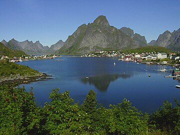 Reine
Reine Hamnøy
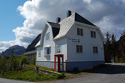 Norwegian Telecom Museum in Sørvågen
 Village of Å
 Djupfjorden, toward the northwest, in autumn


See also
References
- Store norske leksikon. "Moskenesøya" (in Norwegian). Retrieved 13 June 2012.
- Seppälä, Matti (2005). The physical geography of Fennoscandia. Oxford University Press. p. 230. ISBN 0-19-924590-8.
- "Moskenes municipality". VisitNorway.com. Archived from the original on 17 September 2011.
- Porter, Darwin (2009). Frommer's Norway. Hoboken, N.J., Chichester: Frommer's John Wiley distributor. p. 425. ISBN 0-470-43213-6.
- Filippo, H; Pelzers, E (2007). Noord Scandinavië: Lapland, Noordkaap, Lofoten, Spitsbergen (in Dutch). Uitgeverij Elmar. p. 150. ISBN 90-389-1745-7.
- "Norwegian Fishing Village Museum". Archived from the original on 16 July 2011.
- "Norwegian Fishing Village Museum". VisitNorway.com.
- "The bakery at Å, Moskenes, Sørvågen". Archived from the original on 28 September 2011.
- "The cod liver oil factory at Å, Moskenes, Sørvågen".
- "HMS Wheatland". Naval History. Retrieved 18 July 2010.
- "Operation Anklet". Commando operations in Norway. Retrieved 18 July 2010.
Authority control | |
|---|---|
| General |
|
| National libraries | |
На других языках
[de] Moskenesøy
Moskenesøy ist eine Insel im südlichen Teil der Lofoten in Norwegen. Der Hauptort ist Reine, weitere Orte auf Moskenesøy sind unter anderem Moskenes, Å, Sørvågen, Sund, Sakrisøy und Hamnøy.- [en] Moskenesøya
[fr] Moskenesøya
Moskenesøya (en norvégien : « l'île de Moskenes ») est une île de l'archipel des Lofoten, en Norvège.[it] Moskenesøya
Moskenesøya è un'isola appartenente all'arcipelago delle isole Lofoten, nella contea di Nordland, in Norvegia.[ru] Москенесёй
Москенесёй (норв. Moskenesøya) — остров в Норвежском море.Другой контент может иметь иную лицензию. Перед использованием материалов сайта WikiSort.org внимательно изучите правила лицензирования конкретных элементов наполнения сайта.
WikiSort.org - проект по пересортировке и дополнению контента Википедии