geo.wikisort.org - Island
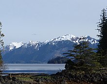
Moresby Island (Haida: Gwaii Haanas) is a large island (3,399.39 km2 or 1,312.51 sq mi) that forms part of the Haida Gwaii archipelago (formerly known as Queen Charlotte Islands) in British Columbia, Canada, located at 52°45′00″N 131°50′00″W.[1] It is separated by the narrow Skidegate Channel from the other principal island of the group to the north, Graham Island.
 Haida Gwaii. Moresby Island is the large southern island. Alaska lies north | |
 Moresby Island Moresby Island (British Columbia, Canada) | |
| Geography | |
| Location | Pacific Ocean |
| Coordinates | 52.75°N 131.8333°W |
| Archipelago | Haida Gwaii |
| Area | 3,399.39 km2 (1,312.51 sq mi) |
| Administration | |
Canada | |
| Province | British Columbia |
| Regional District Electoral Area | North Coast Regional District Electoral Area E |
| Electoral Area Director | Evan Putterill |
| Largest settlement | Sandspit |
| Demographics | |
| Population | 340 (2016) |
| Pop. density | 0.10/km2 (0.26/sq mi) |


Gwaii Haanas National Park Reserve and Haida Heritage Site includes Moresby and other islands. The island, together with numerous nearby smaller islands and islets in the southern archipelago, is defined by Statistics Canada as Skeena-Queen Charlotte E (Now North Coast Regional District Area E), with a population of 340 as of the 2016 census. Almost all of its population resided in the unincorporated community of Sandspit, on the northeast corner of Moresby. The total land area of the electoral area is 3,399.39 km2 (1,312.51 sq mi).

Moresby Island is the 175th largest island in the world, and the 32nd largest island in Canada.
On October 27, 2012, an earthquake of magnitude 7.7 (the strongest earthquake in Canada since the 1949 Queen Charlotte Islands earthquake) was epicentred at a depth of 17.5 kilometres (10.9 miles) under the island.[2]
Name
Moresby Island is named for Rear Admiral Fairfax Moresby of the Royal Navy, as is the smaller Moresby Island in the Gulf Islands. The traditional name in the Haida language is Gwaii Haanas,[citation needed] which is the source of the national park name.
References
- "Moresby Island". BC Geographical Names.
- U.S. Geological Survey October 28, 2012 Haida Gwaii earthquake
External links
- Community Profile: Skeena-Queen Charlotte Regional District Electoral Area E, British Columbia; Statistics Canada
- Sandspit unincorporated place, Skeena-Queen Charlotte Regional District Electoral Area E, British Columbia; Statistics Canada
- Sea islands, Natural Resources Canada Atlas of Canada
На других языках
[de] Moresby Island
Moresby Island (Haida Gwaii Hanas) bildet den südlichen Teil der Haida Gwaii, einer Inselgruppe vor der Nordwestküste von British Columbia, Kanada im Pazifischen Ozean. Sie ist die drittgrößte der kanadischen Pazifikinseln.- [en] Moresby Island
[es] Isla Moresby
La isla Moresby (en inglés, Moresby Island) es una isla grande (2.608 km²), una de las dos grandes islas del archipiélago de Haida Gwaii, perteneciente a la provincia de la Columbia Británica, Canadá.[fr] Île Moresby
L’île Moresby (en anglais : Moresby Island ; en haïda : Gwaii Haanas) est une des îles qui composent l'archipel Haida Gwaii. La réserve de parc national et site du patrimoine haïda Gwaii Haanas englobe l'île.[it] Isola di Moresby
L'isola di Moresby è un'isola appartenente all'arcipelago delle Haida Gwaii situato al largo della provincia canadese della Columbia Britannica.[ru] Морсби (остров)
Мо́рсби[1] (англ. Moresby Island) — второй по величине остров в архипелаге Хайда-Гуаи[2] (более известный как Острова Королевы Шарлотты). Территориально относится к провинции Британская Колумбия.Другой контент может иметь иную лицензию. Перед использованием материалов сайта WikiSort.org внимательно изучите правила лицензирования конкретных элементов наполнения сайта.
WikiSort.org - проект по пересортировке и дополнению контента Википедии