geo.wikisort.org - Island
Mafia Island (Kisiwa cha Mafia) is an island and district of Pwani Region, Tanzania. The island is the third largest in Tanzanian ocean territory,[1] but is not administratively included within the semi-autonomous region of Zanzibar, which has been politically separate since 1890. Mafia Island forms the major part of Mafia District, one of the six administrative districts in the Pwani coastal region. The local archipelago and the main island are sometimes called Chole shamba in Swahili, hinterlands of the former maintown of Chole on Mafia Bay.[2]
Nickname: Home of the Whale Shark | |
|---|---|
 Administrative map (divisions, wards, and villages) | |
 Mafia Island Location of Mafia Island | |
| Geography | |
| Coordinates | 7°51′S 39°47′E |
| Archipelago | Mafia |
| Area | 435 km2 (168 sq mi) |
| Length | 49 km (30.4 mi) |
| Width | 17 km (10.6 mi) |
| Highest elevation | 53 m (174 ft) |
| Highest point | unnamed hill |
| Administration | |
Tanzania | |
| Region | Pwani Region |
| District | Mafia District |
| Capital city | Kilindoni |
| Largest settlement | Kilindoni (pop. 11,696) |
| Demographics | |
| Population | 46,850 (2012) |
| Ethnic groups | Rufiji, Matumbi |
| Additional information | |
| Time zone |
|
The island's population is over 40,000.[3][4][5] The economy is based on fishing, subsistence agriculture and the market in Kilindoni. The island attracts some tourists, mainly scuba divers, birdwatchers, game fishermen, and people wanting relaxation.[6][7]
Geography
Mafia Island, (394 km2 (152 sq mi)), lies off the east coast of Tanzania opposite the delta of the Rufiji River.[1] The 20 kilometres (12 mi) wide stretch of water between the delta and the island is called the Mafia Channel. Mafia Island is part of a small archipelago with several much smaller islands, some of which are inhabited. The main town on Mafia is Kilindoni on the west coast. On the east coast is Chole Bay, Mafia's protected deep-water anchorage and original harbour. The bay is studded with islets, sandbanks and beaches, and is protected from the east by reefs and Juani Island.
The northernmost point on the island is a coral cliff rising approximately 4.5 metres (15 ft) above the sea called Ras Mkumbi, beyond the cliff the land gradually rises to 24 metres (79 ft).[8] There is a lighthouse at Ras Mkumbi.
Geology
Mafia Island, and the associated archipelago were formed by rifting and uplift of part of the continental shelf during the Pleistocene.[1][9]
Ecology
The main ecosystems on the island are mangrove swamps, coastal forests, scrublands, and grasslands.[1]
Birds
A 115,000 ha area, encompassing Chole Bay, the southern coastline of Mafia and its associated smaller islands, along with the intervening marine waters, has been designated an Important Bird Area (IBA) by BirdLife International because it supports populations of western reef egrets, Terek sandpipers and crab plovers.[10]
Mammals
Mafia Island is home to fruitbats (flying foxes) of the genus Pteropus.[1]
Climate
Mafia Island has a tropical climate. This climate is classified as "Aw" by the Köppen-Geiger system. The average temperature in town of Kilindoni is 26.7 °C (80.1 °F). The average annual rainfall is 1,705 mm. The monthly average temperatures are usually between 24.8–28.3 °C (76.6–82.9 °F). There is one major rain season, with most rainfall coming between March and May. Dry season spans between July to October.
| Climate data for Kilindoni | |||||||||||||
|---|---|---|---|---|---|---|---|---|---|---|---|---|---|
| Month | Jan | Feb | Mar | Apr | May | Jun | Jul | Aug | Sep | Oct | Nov | Dec | Year |
| Average high °C (°F) | 31.3 (88.3) |
31.6 (88.9) |
31.3 (88.3) |
29.9 (85.8) |
29.3 (84.7) |
28.3 (82.9) |
27.5 (81.5) |
28.2 (82.8) |
29.3 (84.7) |
30.3 (86.5) |
30.6 (87.1) |
31.1 (88.0) |
29.9 (85.8) |
| Daily mean °C (°F) | 28.3 (82.9) |
28.3 (82.9) |
28.1 (82.6) |
27.0 (80.6) |
26.4 (79.5) |
25.4 (77.7) |
24.8 (76.6) |
25.0 (77.0) |
25.7 (78.3) |
26.8 (80.2) |
27.2 (81.0) |
27.8 (82.0) |
26.7 (80.1) |
| Average low °C (°F) | 25.3 (77.5) |
25.1 (77.2) |
25.0 (77.0) |
24.2 (75.6) |
23.5 (74.3) |
22.6 (72.7) |
22.1 (71.8) |
21.9 (71.4) |
22.2 (72.0) |
23.3 (73.9) |
23.9 (75.0) |
24.6 (76.3) |
23.6 (74.5) |
| Average precipitation mm (inches) | 134 (5.3) |
98 (3.9) |
234 (9.2) |
482 (19.0) |
260 (10.2) |
80 (3.1) |
49 (1.9) |
25 (1.0) |
22 (0.9) |
35 (1.4) |
102 (4.0) |
184 (7.2) |
1,705 (67.1) |
| Source: Climate-Data.ORG[11] | |||||||||||||
History
Mafia Island is mentioned at least as early as the 8th century. The island once played a major role in ancient trade between the people of East Asia and East Africa. It was a regular stop for Arab boats. On the tiny island of Chole Mjini, just offshore in Chole Bay, once stood a settlement that constituted one of the most important towns controlling trade from the silver mines of Eastern Zimbabwe, which reached the town via the old ports of Kilwa and Michangani.[12]
In the mid-1820s, the town of Kua on Juani Island was attacked by Sakalava cannibals arriving from Madagascar with 80 canoes, who ate many of the locals and took the rest into slavery.[12]
A 3D documentation of the Kua Ruins on Juani Island was carried out in 2018 by the Zamani Project.[13]
Under a treaty of 1890, Germany took control of Mafia and constructed the buildings still evident on Chole. Germany paid Sultan Sayyid Ali bin Said al-Said of Zanzibar M4 million for both the island and part of the mainland coast. On January 12, 1915, Mafia was taken by British troops as a base for the air and sea assault on the light cruiser Königsberg.
The name "Mafia" derives from the Arabic morfiyeh, meaning "group" or "archipelago"[citation needed], or from the Swahili mahali pa afya, meaning "a healthy dwelling-place".
In 1995, Mafia Island had financial help from the WWF to make a natural marine wildlife centre which led to establishment of the first Marine Park in Tanzania. The organization continued to provide support to the Island under Rufiji-Mafia-Kilwa (RUMAKI)[14] seascape project to improve socio-economic well-being of the communities through the sustainable, participatory and equitable utilization and protection of their natural resources. Under the current EU-WWF Fisheries Co-management Project,[15] the organization aims at building effective long-term fisheries co-management through establishment of 10 Beach Management Units and to continue supporting Village Community Banks (VICOBA) in the Island to generate optimal, sustainable and equitable livelihood benefits, and which provide a source of lesson-learning for other coastal communities. The WWF Mafia office is under three technical staff - Paul Kugopya (Mafia Fisheries Co-management Officer), Marko Gideon[16] (EU-WWF Fisheries Co-management Project Communication/Awareness Officer) and Renatus Rwamugira (Project Accountant for Mafia).
Tanzania's first multi-user marine park at Mafia Island was established in 1995 following management recommendations and data from surveys conducted by the Society for Environmental Exploration.[17]
In August 2016, a diver, Alan Sutton, from Seaunseen, who had originally been looking for the remains of an old fort rumoured to have been washed away to sea, instead came across the remains of a wall stretching almost 4 km off Mafia Island. The discovery was detailed in a blog post by Sutton, with images showing remnants of the wall.[18]
Transport

Airport
The island's Mafia Airport can be reached from Dar es Salaam by flights operated by Auric Air[19] and Coastal Aviation.[20]
Port of Mafia Island
Boats depart depending on the presence of the boat from the village of Nyamisati on the mainland to Kilindoni on Mafia island. As of 2021 the departure from Nyamisati is 16:00 p.m. with a roll call between 15:00-16:00p.m. The journey takes approximately 4.5 hours. Tickets are purchased beforehand in Nyamisati at a cost of 16,000 Tsh one way.
See also
- Geography of Tanzania
- Mafia Island Marine Park
Gallery
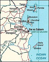 A map of Tanzania showing Mafia Island
 Districts of Pwani Region showing Mafia District
 Historical nautical chart
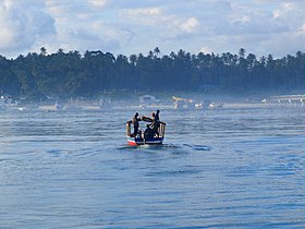 Harbour of Mafia Island as seen from a departing boat
 Beach on Mafia Island
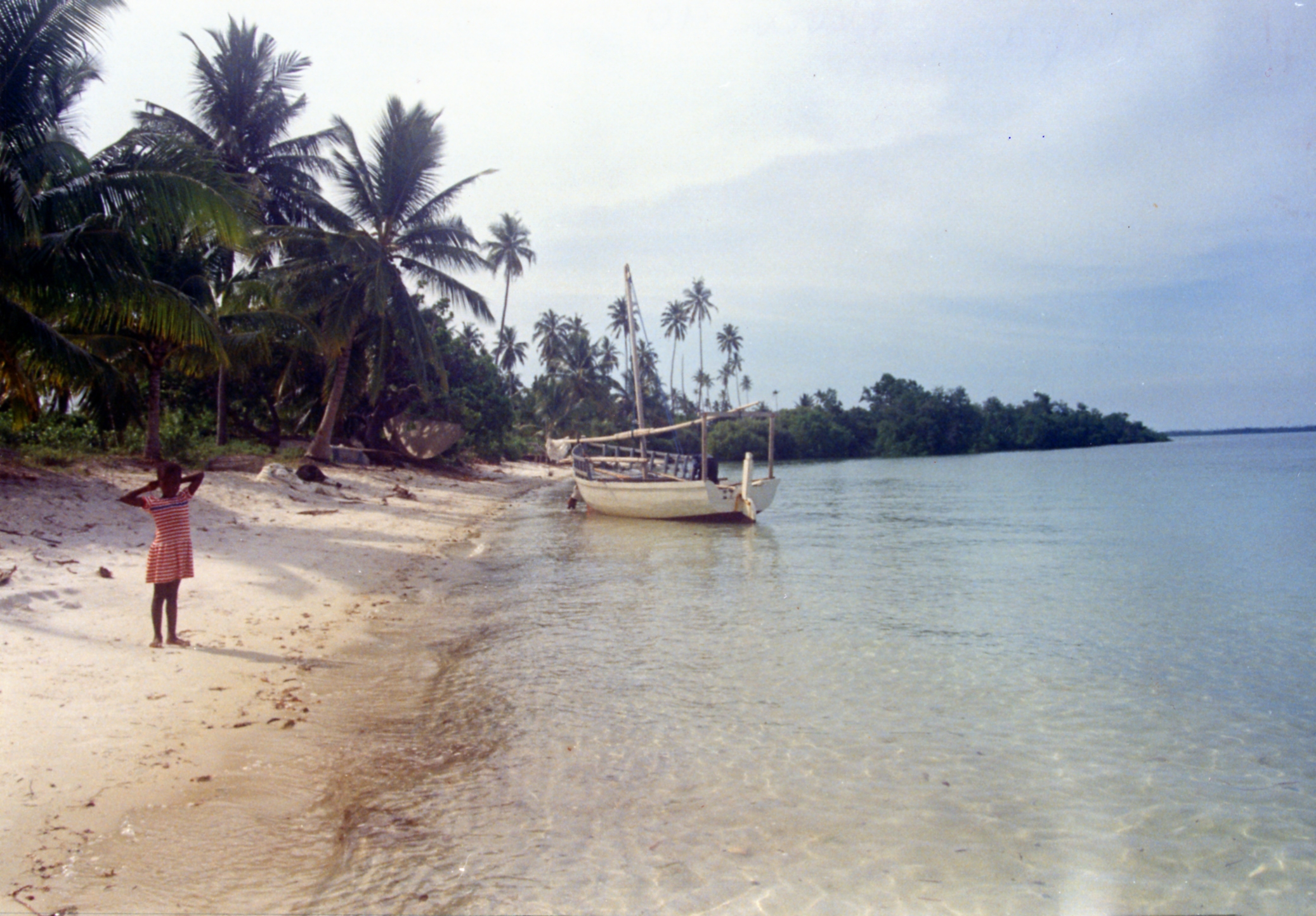


Sources
References
- Kock, Dieter; Stanley, William T. (2009). "Mammals of Mafia Island, Tanzania". Mammalia. 73 (4): 339–352. doi:10.1515/MAMM.2009.046. S2CID 83780678.
- "Mafia in Detail: History". Lonely Planet. Archived from the original on 24 March 2021.
- "2002 POPULATION AND HOUSING CENSUS- General Report". Archived from the original on 2007-06-10. Retrieved 2016-02-03.
- Administrator. "Policies". mca-t.go.tz. Archived from the original on 2012-04-25.
- Office of Chief Government Statistician (2016). "Pwani Region: Basic Demographic and Socio-Economic Profile (2012 Population and Housing Census)". National Bureau of Statistics (Tanzania).
- "Mafia Island". The Africa Specialists. 19 February 2013. Archived from the original on 5 August 2020.
- Kingdom, Sarah (22 November 2020). "Why You Should Add Mafia Island To Your Travel Bucket List". Travel Awaits. Archived from the original on 26 January 2021.
- "Mafia Island". Sailing Directions (enroute) for East Africa and the South Indian Ocean. Hydrographic/Topographic Center, Defense Mapping Agency (US). 1983. p. 95.
- Sii, Petrus; Underhill, John R. (2015). "Role of Punctuated Subsidence and Structural Inversion in Creating East African Spice Islands". 77th EAGE Conference and Exhibition. 77th EAGE Conference and Exhibition 2015. European Association of Geoscientists & Engineers. pp. 1–5. doi:10.3997/2214-4609.201412973. ISBN 978-94-6282-146-0. OCLC 7378154858.
- "Mafia Island". BirdLife Data Zone. BirdLife International. 2021. Retrieved 28 February 2021.
- "Kilindoni". Retrieved July 26, 2017.
- "Mafia Island – Indian Ocean, Tanzania". Retrieved 2020-05-28.
- "Kua Ruins - Remains from a medieval Swahili town on Juani Island, Tanzania". Zamani Project. Retrieved 29 November 2019.
- "WWF - Rufiji-Mafia-Kilwa Seascape Programme, Tanzania". panda.org.
- "European Union". europa.eu. Archived from the original on 2016-03-16. Retrieved 2013-09-19.
- Mark Shekalaghe. "Tembelea Tanzania". safiritz.blogspot.com.
- "Frontier : Conservation, Education and Exploration » About Frontier: Conservation and Development NGO » Tangible Conservation & Development Achievements". 12 October 2007. Archived from the original on 12 October 2007.
{{cite web}}: CS1 maint: bot: original URL status unknown (link) - Osborne, Hannah (13 May 2016). "Diver in Tanzania discovers ancient city submerged beneath the sea off Mafia Island".
- "Auric Air". Auric Air Services Ltd. March 30, 2012. Retrieved March 30, 2012.
- "Coastal Aviation". August 5, 2017.
- Chami, F. A. 1999. “The Early Iron Age on Mafia island and its relationship with the mainland.” Azania Vol. XXXIV 1999, pp. 1–10.
- Chami, Felix A. 2002. “The Graeco-Romans and Paanchea/Azania: sailing in the Erythraean Sea” by Felix A. Chami. From: Red Sea Trade and Travel. The British Museum. Organised by The Society for Arabian Studies. Downloaded on 20 July 2003 from thebritishmuseum.ac.uk (archive)
External links
Underwater diving | |||||||||||||||||||||||||||||||||||||
|---|---|---|---|---|---|---|---|---|---|---|---|---|---|---|---|---|---|---|---|---|---|---|---|---|---|---|---|---|---|---|---|---|---|---|---|---|---|
| |||||||||||||||||||||||||||||||||||||
| |||||||||||||||||||||||||||||||||||||
| |||||||||||||||||||||||||||||||||||||
| |||||||||||||||||||||||||||||||||||||
| |||||||||||||||||||||||||||||||||||||
| |||||||||||||||||||||||||||||||||||||
| |||||||||||||||||||||||||||||||||||||
| |||||||||||||||||||||||||||||||||||||
| |||||||||||||||||||||||||||||||||||||
| |||||||||||||||||||||||||||||||||||||
| |||||||||||||||||||||||||||||||||||||
| |||||||||||||||||||||||||||||||||||||
| |||||||||||||||||||||||||||||||||||||
| |||||||||||||||||||||||||||||||||||||
| |||||||||||||||||||||||||||||||||||||
| |||||||||||||||||||||||||||||||||||||
| |||||||||||||||||||||||||||||||||||||
Authority control | |
|---|---|
| General |
|
| National libraries | |
На других языках
[de] Mafia (Insel)
Mafia ist eine tansanische Insel, die östlich des Rufiji-Flussdeltas vor der ostafrikanischen Küste im Indischen Ozean liegt.- [en] Mafia Island
[es] Isla de Mafia
La isla de Mafia ("Chole Shamba") es parte del archipiélago de Zanzíbar en Tanzania, junto con las islas de Unguja y Pemba.[fr] Mafia (île)
Mafia, en swahili Kisiwa cha Mafia, est une île de Tanzanie située dans l'océan Indien ne faisant pas partie de l'archipel de Zanzibar bien qu'elle soit située non loin au sud. Mafia n'est pas administrée par le Gouvernement révolutionnaire de Zanzibar qui administre les deux autres îles principales de l'archipel, Unguja et Pemba, mais fait partie de la région de Pwani dont elle constitue l'un des six districts.[it] Mafia (isola)
Mafia, conosciuta anche come Chole Samba, è un'isola della Tanzania, situata nell'Oceano Indiano a circa 25 km dalla costa del continente. Insieme a Zanzibar e a Pemba appartiene a un gruppo di isole talvolta indicato col nome di "isole delle spezie".[ru] Мафия (остров)
Мафи́я[1] (англ. Mafia Island) — главный остров одноимённого архипелага в Танзании, в Индийском океане[2]. Округ области Пвани. Площадь поверхности — 435 км².[источник не указан 591 день]Другой контент может иметь иную лицензию. Перед использованием материалов сайта WikiSort.org внимательно изучите правила лицензирования конкретных элементов наполнения сайта.
WikiSort.org - проект по пересортировке и дополнению контента Википедии