geo.wikisort.org - Island
Lovund is an island and village in the municipality of Lurøy in Nordland county, Norway. The island is located west of the Solvær islands and southeast of the Træna islands. Lovund is notable for the large puffin breeding colony located on the rocky north slope of the island.[1]
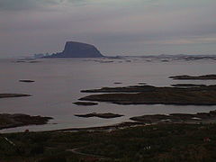
 Lovund with Træna in the background | |
 | |
 Lovund Location of the island  Lovund Lovund (Norway) | |
| Geography | |
|---|---|
| Location | Nordland, Norway |
| Coordinates | 66.3641°N 12.3372°E |
| Area | 4.9 km2 (1.9 sq mi) |
| Length | 3 km (1.9 mi) |
| Width | 2.5 km (1.55 mi) |
| Highest elevation | 623 m (2044 ft) |
| Highest point | Lovundfjellet |
| Administration | |
Norway | |
| County | Nordland |
| Municipality | Lurøy Municipality |
| Demographics | |
| Population | 499 (2018) |
The village of Lovund (sometimes called Strand) is located in the northeastern part of the island. The 0.53-square-kilometre (130-acre) village has a population (2018) of 499 and a population density of 942 inhabitants per square kilometre (2,440/sq mi).[2] Lovund Church, located in the village, serves the people of the island.
Name
The Old Norse form of the name might have been Laufund. The first element is then lauf which means "leaf" or "broad-leaved trees", referring to the fact that the western part of the island is covered with a forest. The last element is the suffix -und meaning "land". (see Borgund).
Media gallery
 Lovund seen from Dønna
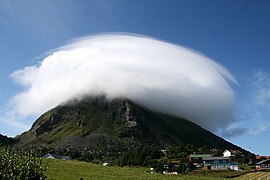 Lovund village
 View of the island
 Lundeura - location of the puffin colony
 View near Nesna, Norway, showing the settlement of Lillevik in the foreground. The island of Lovund in the distant horizon.


References
- Store norske leksikon. "Lovund" (in Norwegian). Retrieved 2012-01-27.
- Statistisk sentralbyrå (1 January 2018). "Urban settlements. Population and area, by municipality".
This article about an island in Nordland is a stub. You can help Wikipedia by expanding it. |
Другой контент может иметь иную лицензию. Перед использованием материалов сайта WikiSort.org внимательно изучите правила лицензирования конкретных элементов наполнения сайта.
WikiSort.org - проект по пересортировке и дополнению контента Википедии