geo.wikisort.org - Island
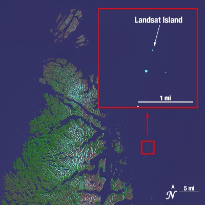
Landsat Island is a small, uninhabited island located at approximately 60°10'37"N 64°02'30"W, 20 kilometres (12 mi) off the northeast coast of Labrador (part of the Canadian province of Newfoundland and Labrador). It was discovered in 1976[1] during the analysis of imagery from the Landsat 1 satellite. The island is only 25 by 45 metres (82 ft × 148 ft), with a total area of 1,125 square metres (12,110 sq ft).
Discovery
In 1976, a Canadian coastal survey was carried out using data from the Landsat 1 satellite. Analysis of the data revealed several previously uncharted features; this includes Landsat Island, which was subsequently named after the satellite. Verification of the island's existence fell to Dr. Frank Hall of the Canadian Hydrographic Service:
[Dr. Hall] was strapped into a harness and lowered from a helicopter down to the island. This was quite a frozen island and it was completely covered with ice. As he was lowered out of the helicopter, a polar bear took a swat at him. The bear was on the highest point on the island and it was hard for him to see because it was white. Hall yanked at the cable and got himself hauled up. He said he very nearly became the first person to end his life on Landsat Island.
— From Scott Reid's account of Dr. Hall's Landsat Island expedition given to the Canadian Parliament on October 30, 2001[2]
Following Dr. Hall's encounter with the polar bear, it was suggested that the island be named "Polar Island,"[3] but the present name was retained.
Landsat Island marks the easternmost point of the Canadian land mass along this section of the Labrador coast. As such, its discovery increased Canada's maritime territory by 68 square kilometres (26 sq mi).
References
- Gray, David H. (Summer 2000). "Discovering Rocks Off Labrador: A Photo Essay" (PDF). IBRU Boundary and Security Bulletin: 89, 99. Retrieved 2013-07-15.
- Scott Reid, Member for Lanark—Carleton (October 30, 2001). "Constitution of Canada". Parliamentary Debates (Hansard). Canada: House of Representatives. col. 1305.
- Rocchio, Laura (April 19, 2006). "Landsat Island". National Aeronautics and Space Administration. Archived from the original on November 4, 2012. Retrieved 2013-07-15.
External links
- NASA article: Landsat Island (April 19, 2006)
- David H. Gray, "Discovering Rocks off Labrador: A Photo Essay", IBRU Boundary and Security Bulletin, Summer 2000.
На других языках
[de] Landsat Island
Landsat Island (deutsch „Landsat-Insel“) ist eine kleine unbewohnte Insel, die 20 km entfernt von der Nordostküste Labradors (Kanada) liegt. Sie wurde erst 1976[1] bei der Analyse von Bildmaterial des Satelliten Landsat-1 entdeckt und umfasst lediglich eine Fläche von 25 m ×45 m, also 1125 m².- [en] Landsat Island
[fr] Île Landsat
L'Île Landsat (Landsat Island en anglais) est une petite île canadienne inhabitée, située à 20 km au large des côtes du Labrador, faisant partie de la province canadienne de Terre-Neuve-et-Labrador. Elle a été découverte en 1976[1] lors de l'étude d'une image satellite prise par le satellite d'observation Landsat 1. Ses dimensions sont de 25 m sur 45 m soit 1125 m².Другой контент может иметь иную лицензию. Перед использованием материалов сайта WikiSort.org внимательно изучите правила лицензирования конкретных элементов наполнения сайта.
WikiSort.org - проект по пересортировке и дополнению контента Википедии