geo.wikisort.org - Island
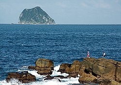
Keelung Islet (Chinese: 基隆嶼; pinyin: Jīlóng Yǔ; Wade–Giles: Chi1-lung2 Yü3, also 基隆島, in Taiwanese Hokkien: 雞籠杙/Ke-lâng-khit) is a small island in Zhongzheng District, Keelung, Taiwan and 4.9 km (3.0 mi) away from the Port of Keelung. It has an area of 27,005.593 m2 (0.010426918 sq mi)[3] or 23.91 ha (59.08 acres). It is 910 m (2,986 ft) in length, and 410 m (1,345 ft) in width including the artificial harbor, the highest point is 182 m (597 ft) above sea level.[4]
Native name: 基隆嶼, 基隆島 | |
|---|---|
 | |
| Geography | |
| Location | Zhongzheng, Keelung, Taiwan[1][2] |
| Coordinates | 25°11′32″N 121°47′08″E |
| Area | 23.91 ha (59.1 acres) |
| Length | 910 m (2990 ft) |
| Width | 410 m (1350 ft) |
| Highest elevation | 182 m (597 ft) |
History

In ancient times, the island was seen as a sacred place by locals. It was rumoured that a female ghost named Shih-Yun lived there, to mourn over her husband who died in a shipwreck hundreds of years ago.
In the modern day, the islet is primarily used as a military training base. Since 2001, it has been opened for tourists.[5] Ferry services to the island operate daily from the port of Keelung. There is a small port and a walkway on the island. The island is also popular with the local fishing industry, because of the quantity of fish it attracts in its surrounding sea.
In 2013, the islet was closed to visitors following Typhoon Soulik. The islet remained closed to the public as damage from Typhoon Soudelor in 2015 was repaired. In July 2017, the city government allocated NT$82 million for the island's infrastructure reparation and renovation works.[6] Plans to reopen for tourists in August 2018 were delayed until June 2019.[7][8][9] The islet was finally reopened again on 25 June.[6]
Geography
The island is volcanic, part of the Chilung Volcano Group. It dates from the Pleistocene period. The eruption was explosive tholeiitic andesite and dacite. The main mineral is calcium rich plagioclase. The magma source is the western extremity of the Ryukyu Volcanic Arc formed when the subducting Philippine Sea Plate was compressed below the edge of the Eurasian Plate at about 20 to 30 km deep. The magma was contaminated with continental crust material. Geochemistry of the rock shows that iron, aluminium, titanium, potassium, rubidium and strontium are enriched, but sodium, magnesium and nickel are impoverished.[10]
Transportation
The island can be accessed from Keelung mainland at Badouzi, Bisha or Keelung Ports.[6]
See also
References
- "Beautiful Scenery". Keelung City Government. Retrieved 23 April 2019.
Keelung Islet
- 基隆市土地段名代碼表 (in Chinese (Taiwan)). Department of Land Administration. 16 December 2014. Retrieved 22 September 2019.
基隆市土地段名代碼表 地政事務所名稱(代碼) 信義(CB) 鄉鎮市區名稱(代碼) 中正區(01){...}段 小段 代碼 備註{...}基隆嶼 0126
- 轄區介紹. 基隆市中正區公所. Retrieved 22 September 2019.
基隆嶼 27005.593
- "Keelung Islet". Taiwan, the Heart of Asia. Retrieved 14 May 2018.
- Lu, Hsien-hsiu; Tsai, Yi-hsuan; Pan, Jason (23 February 2013). "Keelung eyeing offshore casino". Taipei Times. Retrieved 21 June 2019.
- Wang, Chao-yu; Lim, Emerson (20 June 2019). "Keelung Islet to reopen to tourists after 5-year closure". Focus Taiwan. Retrieved 1 October 2019.
- Teng, Pei-ju (12 May 2018). "1.5-ton garbage removed from Taiwan's Keelung Islet in two hours". Taiwan News. Retrieved 14 May 2018.
- Wang, Chao-yu; Lim, Emerson (21 June 2019). "Keelung Islet to reopen to tourists after 5-year closure". Central News Agency. Retrieved 21 June 2019.
- Nguyen, Alicia (4 September 2018). "Taiwan's Keelung Islet reopens for sightseeing by the end of September". Taiwan News. Retrieved 21 June 2019.
- Zhang Jinhai and He Lishi (2002). "Geology of Taiwan Province". Geology of China. Geological Publishing House. ISBN 7-116-02268-6.
{{cite book}}: CS1 maint: uses authors parameter (link)
На других языках
- [en] Keelung Islet
[es] Islote Keelung
Islote Keelung[1] (en chino: 基隆嶼; chino simplificado: 基隆屿; Wade–Giles: Kēelόng Yǔ) es una pequeña isla situada a 3,35 kilómetros (2,08 millas) al noreste de la costa norte de Keelung, Taiwán[2] y a 4,9 km (3,0 millas) de distancia desde el puerto de Keelung. Tiene una superficie de 23,91 hectáreas (59,08 acres). Se trata de una isla de 910 m (2.986 pies) de longitud y 410 m (1.345 pies) de ancho, incluido el puerto artificial, el punto más alto alcanza los 182 m (597 pies) sobre el nivel del mar.[fr] Îlot Keelung
L'îlot Keelung (Chinois traditionnel: 基隆嶼; pinyin: Jīlóngyǔ; Wade–Giles: Chi-lung Yü) est une petite île appartenant au district de Zhongzheng de la ville de Keelung à Taiwan. Située à 4,9 kilomètres du port de Keelung, elle couvre une superficie de 23,9 hectares (910 mètres de long et 410 mètres de large en incluant le port) et son point culminant atteint les 182 mètres au-dessus du niveau de la mer[1].Другой контент может иметь иную лицензию. Перед использованием материалов сайта WikiSort.org внимательно изучите правила лицензирования конкретных элементов наполнения сайта.
WikiSort.org - проект по пересортировке и дополнению контента Википедии
