geo.wikisort.org - Island
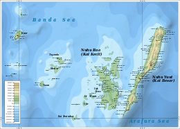
Kai Besar (Great Kai Island, also Nuhu Yuut or Nusteen) is one of the Kai Islands which are part of the Maluku Islands, Indonesia. Its area is 550 km2 (210 sq mi). The other main island in the Kai Islands group is Kai Kecil (Little Kai Island). The northern tip is called Tanjung Borang, and southern tip called Tanjung Weduar.[1]
 The Kai Islands, with Kai Besar in the east | |
 Kai Besar Location on a map of the Maluku Islands | |
| Geography | |
|---|---|
| Location | Southeast Asia |
| Coordinates | |
| Archipelago | Kai Islands |
| Administration | |
Indonesia | |
| Province | Maluku |
| Additional information | |
| Time zone |
|
References
- Prostar Sailing Directions 2004 New Guinea Enroute. ProStar Publications. 1 January 2004. p. 70. ISBN 978-1-57785-569-9.
External links
 Media related to Kai Besar at Wikimedia Commons
This article about a location in Maluku Province is a stub. You can help Wikipedia by expanding it. |
На других языках
[de] Kei Besar
Kei Besar (Kai Besar, lokal: Nuhu Yuut oder Nusteen) ist eine 550 km² große Insel der Kei-Inseln im Archipel der Molukken. Der nördliche Teil der Insel wird Tanjung Borang und der südliche Tanjung Wedua genannt.- [en] Kai Besar
[es] Kai Besar
La isla Kai Besar[1] (en indonesio, Pulau Kai Besar o Pulau Kei Besar), también conocida como el Gran Kei, Nuhu Yuuta o Nusteen, es una isla que pertenece al archipiélago de las islas Kai situado en la provincia de Molucas, en el este de Indonesia.[it] Kai Besar
Kai Besar (anche Grande Kei o Nuhu Yuut, Nusteen) è un'isola appartenente all'arcipelago delle Isole Kai situata nella provincia di Maluku, nell'Indonesia orientale.Текст в блоке "Читать" взят с сайта "Википедия" и доступен по лицензии Creative Commons Attribution-ShareAlike; в отдельных случаях могут действовать дополнительные условия.
Другой контент может иметь иную лицензию. Перед использованием материалов сайта WikiSort.org внимательно изучите правила лицензирования конкретных элементов наполнения сайта.
Другой контент может иметь иную лицензию. Перед использованием материалов сайта WikiSort.org внимательно изучите правила лицензирования конкретных элементов наполнения сайта.
2019-2026
WikiSort.org - проект по пересортировке и дополнению контента Википедии
WikiSort.org - проект по пересортировке и дополнению контента Википедии