geo.wikisort.org - Island
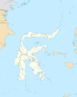
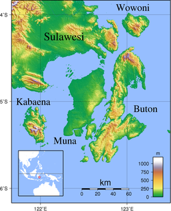
Kabaena or Tokotua is an island in the Flores Sea, Indonesia, off the coast of Sulawesi. Most of it is a part of Bombana Regency within Southeast Sulawesi province, although the southernmost district (Talaga Raya) is administratively part of Central Buton Regency. The island's area is 891.36 km2 and its total population at the 2010 Census was 35,558[1] and at the 2020 Census was 42,877;[2] the official estimate as at mid 2021 was 43,464.[3]
 Kabaena | |
| Geography | |
|---|---|
| Location | South East Asia |
| Coordinates | 5°15′S 121°55′E |
| Area | 891.36 km2 (344.16 sq mi) |
| Administration | |
| Province | |
| Demographics | |
| Population | 43,464 (mid 2021 estimate) |
| Pop. density | 48.8/km2 (126.4/sq mi) |
Administrative Districts
The island includes six of the 22 districts of Bombana Regency, and one district of Central Buton Regency. These seven districts are tabulated below with their areas and their populations at the 2010 Census[4] and the 2020 Census,[5] together with the official estimates as at mid 2021.[6] The table also includes the administrative centre of each district, the number of administrative villages (rural desa and urban kelurahan) and small offshore islands in each district, and its post code.
| Name | Area in km2 | Population Census 2010 | Population Census 2020 | Population Estimate mid 2021 | Administrative centre | Number of villages | Number of islands | Post code |
|---|---|---|---|---|---|---|---|---|
| Kabaena Utara (North Kabaena) | 132.97 | 3,671 | 4,031 | 4,056 | Tedubara | 6 | 4 | 93785 |
| Kabaena Barat (West Kabaena) | 39.43 | 7,492 | 7,829 | 7,854 | Baliara | 5 | 7 | 93780 |
| Kabaena | 103.57 | 2,849 | 3,120 | 3,139 | Teomokole | 4 | - | 93781 |
| Kabaena Selatan (South Kabaena) | 129.20 | 2,606 | 3,325 | 3,395 | Batuawu | 4 | - | 93782 |
| Kabaena Tengah (Central Kabaena) | 275.58 | 3,254 | 4,064 | 4,141 | Lengora | 7 | - | 93783 |
| Kabaena Timur (a) (East Kabaena) | 121.25 | 6,663 | 7,566 | 7,639 | Dongkala | 7 | 2 | 93784 |
| Talaga Raya (b) | 89.36 | 9,023 | 12,942 | 13,240 | Talaga Satu | 7 | 5 | 93766 |
| (Total of Kabaena Island) | 891.36 | 35,558 | 42,877 | 43,464 | 40 | 18 |
Note: (a) Includes the offshore islands of Damalawa Besar and Damalawa Kecil. (b) Talaga Raya District comprises the southern part of Kabaena Island together with two smaller islands
off its south-east coast - Talaga Besar (Great Talaga) and Talaga Kecil (Little Talaga); over 60% of the district's population inhabit Talaga Kecil, which contained 7,836 inhabitants
(at the 2020 Census) in its area of 3.29 km2.
Villages
The island's 40 villages (rural desa and urban kelurahan) are listed below with their areas and their populations at the 2020 Census.[7] Six of the 40 villages (indicated by asterisks below) have the status of kelurahan, while the other 34 are desa.
|
|
References
- Biro Pusat Statistik, Jakarta, 2011.
- Badan Pusat Statistik, Jakarta, 2021.
- Badan Pusat Statistik, Jakarta, 2022.
- Biro Pusat Statistik, Jakarta, 2011.
- Badan Pusat Statistik, Jakarta, 2021.
- Badan Pusat Statistik, Jakarta, 2022.
- Badan Pusat Statistik, Jakarta, 2021.
This Southeast Sulawesi location article is a stub. You can help Wikipedia by expanding it. |
На других языках
[de] Kabaena
Kabaena (indonesisch: Pulau Kabaena) ist eine in der Bandasee gelegene, zur Provinz Südostsulawesi gehörige, 873 km² große indonesische Insel im Südosten von Sulawesi mit 26.535 Bewohnern (2010).[1]- [en] Kabaena
[fr] Kabaena
Kabaena, en indonésien Pulau Kabaena, est une île d'Indonésie située dans la mer de Florès, au large de la péninsule sud-est de Sulawesi.[it] Kabaena
Kabaena è un'isola ubicata nel Mar di Flores, Indonesia, al largo della costa sudorientale di Sulawesi.[ru] Кабаэна
Кабаэна[1] (индон. Kabaena) — остров в Индонезии. Расположен к юго-востоку от Сулавеси, в провинции Юго-Восточный Сулавеси. Площадь — 901 кв. км. Население (2010) — 35558 человек.Другой контент может иметь иную лицензию. Перед использованием материалов сайта WikiSort.org внимательно изучите правила лицензирования конкретных элементов наполнения сайта.
WikiSort.org - проект по пересортировке и дополнению контента Википедии