geo.wikisort.org - Island
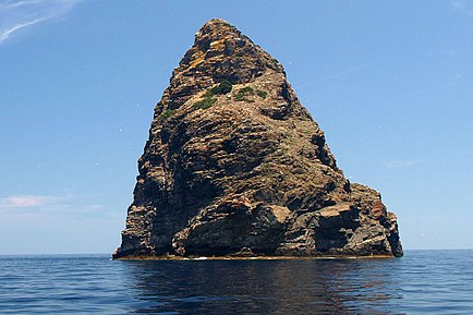
Jabuka (pronounced [jâbuka], which means apple in Croatian) is an uninhabited volcanic island in the Adriatic Sea, west of the island of Vis.[1][2] It is part of the Dalmatian archipelago. The closest land masses are the small islands of Svetac and Brusnik. Jabuka is the farthest from the nearest land mass out of all Croatian islands.

Flora and fauna
Its coast is steep and difficult to approach, and landings can be made only when the weather is clear.[3] The easiest access is on the south-west side. On the island, noteworthy species such as a Dalmatian Wall Lizard and some plants (Centaurea jabukensis and Centaurea crithmifolia, both Asteraceae) are protected endemics. In 1958 the island was declared a geological monument of nature. The surrounding sea is rich with fish, especially sea bream. However, due to remoteness, lack of safe harbor, strong currents, and sudden changes of weather, fishermen have traditionally avoided the waters around Jabuka.[4]
Geological features
Jabuka has 97-meter (318 ft) tall cliffs. All sea lanes avoid the island, because its magnetic form confuses compasses.[citation needed] Due to its iron-rich rock, Jabuka is frequently struck by lightning.[5]: 177
The area around the island is prone to earthquakes due to the Jabuka–Andrija Fault. In 2003, the island was struck by a long series of earthquakes, the largest of which was Mw 5.5.[5] Another series occurred in 2004–05 with a ML 5.2 quake.[6]: 100–101 However, due to Jabuka's remoteness, these earthquakes are weakly felt on the Croatian mainland and inhabited islands.
References
- Walking in Croatia by Rudolf Abraham
- Frommer's Croatia by Karen Torme Olson
- Šerić 2006, p. 15.
- Šerić 2006, pp. 12, 14.
- Herak, Davorka; Herak, Marijan; Prelogović, Eduard; Markušić, Snježana; Markulin, Željko (April 2005). "Jabuka island (Central Adriatic Sea) earthquakes of 2003". Tectonophysics. 398 (3–4): 167–180. doi:10.1016/j.tecto.2005.01.007.
- Ivančić, Ines; Herak, Davorka; Markušić, Snježana; Sović, Ivica; Herak, Marijan (30 December 2006). "Seismicity of Croatia in the period 2002-2005". Geofizika. 23 (2): 87–103. ISSN 0352-3659. Retrieved 19 April 2022.
Bibliography
- Šerić, Neven (2006). Biserna ogrlica - pučinski otoci srednjeg Jadrana (RTF) (in Croatian). Marjan tisak. ISBN 953-214-367-X. Retrieved 5 July 2018.
На других языках
[de] Jabuka (Adria)
Jabuka (kroatisch für „Apfel“) ist eine kegelförmige, unbewohnte Insel vulkanischen Ursprungs mit einer Fläche von 0,022 km² in der Adria westlich von Vis.- [en] Jabuka (island)
[it] Isolotto Pomo
L'isolotto Pomo[3][4][5] o scoglio Pomo[6] (in lingua croata otok Jabuka) è un isolotto vulcanico disabitato nel mare Adriatico, sito tra Pescara e Spalato, circa 70 km ad ovest dell'Isola di Lissa e circa 21 M a nord-ovest di Sant'Andrea in Pelago; fa parte dell'arcipelago di Lissa. Amministrativamente appartiene al comune di Comisa, nella regione spalatino-dalmata.[ru] Ябука (остров)
Я́бука (хорв. Jabuka — яблоко) — небольшой необитаемый вулканический островок в хорватской части Адриатического моря, административно относится к Сплитско-Далматинской жупании. Находится в 50 километрах к западу от острова Вис.Другой контент может иметь иную лицензию. Перед использованием материалов сайта WikiSort.org внимательно изучите правила лицензирования конкретных элементов наполнения сайта.
WikiSort.org - проект по пересортировке и дополнению контента Википедии