geo.wikisort.org - Island
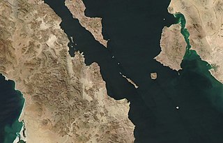
Isla Ángel de la Guarda, (Guardian Angel Island) also called Archangel Island, is a large island in the Gulf of California (Sea of Cortez) east of Bahía de los Ángeles in northwestern Mexico, separated from the Baja California Peninsula by the Canal de Ballenas (Whales Channel). It is the second largest of the eleven Midriff Islands or Islas Grandes. It is part of the state of Baja California, located northwest of Tiburón Island. It is a biological reserve called Isla Angel de la Guarda National Park. The island is part of the Mexicali municipality.
 Isla Ángel de la Guarda | |
| Geography | |
| Location | Gulf of California |
| Coordinates | 29°15′36″N 113°22′13″W |
| Total islands | 5 |
| Major islands | 1 |
| Area | 931 km2 (359 sq mi) |
| Highest elevation | 1,305 m (4281 ft) |
| Highest point | Unnamed Peak |
| Administration | |
| State | Baja California |
| Demographics | |
| Population | 0 |
The geologically active Ballenas Fault runs along the seabed of the linear Canal de Ballenas. A 6.9 magnitude earthquake occurred on this fault in 2009.
Geography
The island is extremely dry, with no sources of freshwater other than washes following rainfall. It has an area of 931 square kilometers (359 sq mi) and a chain of mountains runs along its 69 km length, reaching a maximum of 1,305 m (4,281 ft) above sea level. It runs northwest to southeast. The west coast is roughly straight in that direction, but the east coast runs inward near the middle before heading outward until it reaches the island's widest point. The coast then runs south for a while before finally returning to its southeasterly direction.
Much of the island is inaccessible due to mountains at or near the shore, especially on the west coast. There are a few flat areas on the coast at the outlets of washes that were created by sediment. These alluvial fans are mostly on the east coast, but a large one is found on the west coast where the island narrows in the middle. Much of the island's geology is made up of volcanic and alluvial sand deposits.[1]
Biology
Despite its extreme dryness, the island is relatively diverse in plant and animal life. There are many types of birds and reptiles, especially lizards. The Angel Island chuckwalla, Angel Island speckled rattlesnake (Crotalus angelensis) and Angel Island mouse (Peromyscus guardia) occur only on the island. The only mammals are bats, rodents, and introduced feral cats. Plants include elephant trees, cacti, grasses, shrubs, succulents, and boojum trees.

Isla Ángel de la Guarda.
See also
- History of the west coast of North America
Notes
- Aitchison, Stewart W. (2010-01-01). The Desert Islands of Mexico's Sea of Cortez. University of Arizona Press. ISBN 9780816527748.
References
На других языках
[de] Isla Ángel de la Guarda
Die Isla Ángel de la Guarda (Seri: Xazl Iimt) ist mit einer Fläche von 931 km² nach der Isla Tiburón die zweitgrößte Insel im Golf von Kalifornien. Sie gehört zum mexikanischen Bundesstaat Baja California und dort zur Municipio Mexicali, Gemeindebezirk (delegación) San Felipe. Die 69 km lange und bis zu 1315 m hohe[1] Insel liegt östlich der Bucht Bahía de los Ángeles unweit der Isla Tiburón.- [en] Isla Ángel de la Guarda
[es] Isla Ángel de la Guarda
La isla Ángel de la Guarda es una gran isla de México localizada en aguas del Golfo de California al este de Bahía de los Ángeles, separada de la península de Baja California por el canal de las Ballenas. La isla es parte del estado de Baja California, específicamente pertenece al municipio de Mexicali y está localizada al noroeste de la isla Tiburón. Hoy en día se encuentra deshabitada y es un área natural protegida. El nombre de su parte norte en el Idioma seri es Xazl Iimt [ˌχaʃɬ ˈiːmt] hogar de los pumas, y el de su parte sur Tjamojíil Yacáai [txɑmo'xi:ɬ jɑ'kɑ:i] donde sigue la chopa.[fr] Île Ángel de la Guarda
L'île Ángel de la Guarda est une des îles mexicaines situées dans le golfe de Californie à 12,4 km au large des côtes de la Basse-Californie mais faisant partie toutefois de la municipalité de Mexicali localisée à 386 km au nord.[it] Isola Ángel de la Guarda
L'isola Ángel de la Guarda, in spagnolo Isla Ángel de la Guarda, in lingua Seri Xazl Iimt, è un'isola messicana situata nella parte nord-occidentale del golfo di California, separata dal resto della penisola di Bassa California dal Canal de Ballenas. Con un'area di 931 km², è la seconda isola del golfo dopo l'Isola di Tiburón, posta a sud-est. Il nome spagnolo, in italiano, significa "isola angelo custode", mentre il significato del nome nativo dell'isola è "casa dei puma".[ru] Анхель-де-ла-Гуарда
А́нхель-де-ла-Гуа́рда[1][2] или Ангель-де-ла-Гуарда[3] (исп. Isla Ángel de la Guarda — «Ангел-хранитель») — мексиканский остров, расположенный в заливе Калифорния (также называемом «Морем Кортеса»), соединяющемся с Тихим океаном. Известно также название этого острова на индейском языке сери — Xazl Iimt ([ˈχaʃɬ ˈiːmt]), что означает «дома́ пум».Другой контент может иметь иную лицензию. Перед использованием материалов сайта WikiSort.org внимательно изучите правила лицензирования конкретных элементов наполнения сайта.
WikiSort.org - проект по пересортировке и дополнению контента Википедии


