geo.wikisort.org - Island
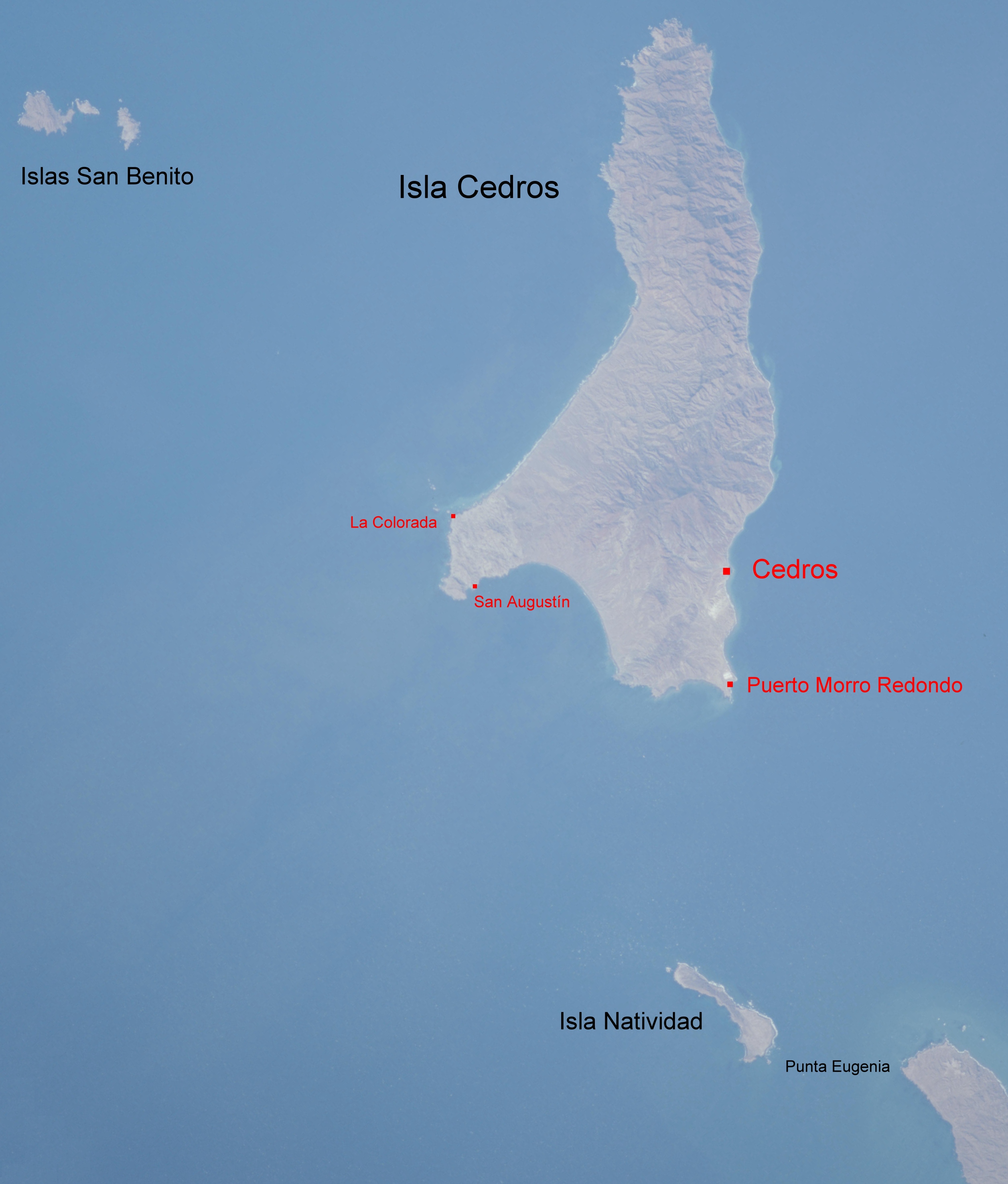
Isla Natividad is an island in the Pacific Ocean 6 km west off Punta Eugenia, the northwestern headland of the Mexican state of Baja California Sur. 200 meters off its northwestern end lies Roca María at 27°53′33″N 115°13′19″W, with an area of 0.074 km2. Isla Natividad is separated from the mainland at Punta Eugenia by Canal de Dewey (Dewey's Channel), and from Cedros Island (Baja California), which is 15 km to the north, by Canal de Keller (Canal Kellett).[1]

Isla Natividad at the bottom
The island is part of Bahía Tortugas delegación of Mulegé municipality. It is 8.655 km2 in area. At the 2001 census,[2] the island had a population of 384, centered in Natividad, a community of abalone, lobster, and clam fishermen, at the southeastern end (27°51′09″N 115°10′09″W). Connection to the mainland is facilitated by an airstrip. There is a lighthouse in the northern part.
Geography and ecology
It has steep rocky shores fringed by rocks and kelp except for a small sandy beach towards the mainland. The island is barren and hilly with a peak 150 m high rising near its center. The flora consists mainly of a dense cover of Mesembryanthemum crystallinum and M. nodiflorum, cacti, and small shrubs. There are no endemic plants or animals on Natividad due to its proximity to the mainland (it was probably part of the mainland several times during the ice ages, when sea levels were lower). However, Mammillaria pondii and a little-researched Opuntioideae cactus, as well as Mentzelia hirsutissima var. nesiotes are found in few other places. Native land vertebrates are few, including the deer mouse Peromyscus maniculatus and some lizards. Seabirds – namely Brandt's cormorant – and seals use the island as a breeding and resting site. Isla Natividad is one of the southernmost breeding locations of Cassin's auklet and a main breeding site for black-vented shearwaters.[3][4]
Restoration
Between 1997 and 2001, Conservacion de Islas removed introduced goat, Capra hircus, domestic sheep Ovis aries, domestic cats Felis catus, domestic dog Canis familiaris, from the island to primarily benefit the black-vented shearwater Puffinus opisthomelas.[5][6]
References
- National Geospatial-Intelligence Agency (2004): Sector 2 – West coast of Baja California. In: PUB153 Sailing Directions (Enroute): West Coasts of Mexico & Central America (10th ed.): 9–18. ProStar Publications, Inc. ISBN 1-57785-559-0
- Instituto Nacional de Estadística, Geografía e Informática (2007): Principales resultados por localidad 2005 (ITER) Archived 2011-06-13 at the Wayback Machine ["Principal results of the 2005 census by locality"] [in Spanish]. Retrieved 2007-OCT-10.
- Thayer, John E.; Bangs, Outram (1907). "Birds Collected by W. W. Brown, Jr., on Cerros, San Benito and Natividad Islands in the Spring of 1906, with Notes on the Biota of the Islands" (PDF). Condor. 9 (3): 77–81. doi:10.2307/1361136. hdl:2027/hvd.32044072249907.
- California/Mexico Island Conservation Database (2007): Plant accounts: Guadalupe Island Archived 2007-12-08 at the Wayback Machine. Retrieved 2007-OCT-10.
- Keitt, Bradford S.; Wilcox, Chris; Tershy, Bernie R.; Croll, Donald A.; Donlan, C. Josh (2002). "The effect of feral cats on the population viability of black-vented shearwaters (Puffinus opisthomelas) on Natividad Island, Mexico". Animal Conservation. 5 (3): 217–223. doi:10.1017/S1367943002002263. ISSN 1367-9430.
- "Database of Island Invasive Species Eradications". DIISE. Island Conservation. Retrieved 1 September 2016.
External links
На других языках
[de] Isla Natividad
Isla Natividad ist eine aride mexikanische Insel im Pazifischen Ozean 6 km vor Punta Eugenia an der nordwestlichen Landzunge des Bundesstaates Baja California Sur, davon getrennt durch den Canal de Deway, und 15 km südlich der Isla de Cedros. Die Insel ist kahl und hügelig.- [en] Isla Natividad
[es] Isla Natividad
Isla Natividad es una isla mexicana ubicada en el Océano Pacífico, en las coordenadas 27°51′09″N 115°10′09″O. Siendo parte de la gran Reserva de la Biosfera del Vizcaíno y sobre todo una zona núcleo de la misma, se considera una zona de alta protección ambiental y una gran variedad en biodiversidad. La isla cuenta con una población limitada al número de trabajadores y sus respectivas familias, esto a causa de la concesión de trabajo que tiene la Sociedad Cooperativa de Producción Pesquera Buzos y Pescadores de la Baja California en Isla Natividad y la vinculación con la Biosfera del Vizcaíno. La principal fuente de trabajo son las pesquerías de mariscos, entre los más populares y redituables, el abulón y langosta. Otros productos son el caracol, pepino de mar, erizo, sargazo y pescado.Другой контент может иметь иную лицензию. Перед использованием материалов сайта WikiSort.org внимательно изучите правила лицензирования конкретных элементов наполнения сайта.
WikiSort.org - проект по пересортировке и дополнению контента Википедии