geo.wikisort.org - Island
Ilha do Algodão (Portuguese: [ˈiʎa duˈauɡu ˈdɐ̃w]) (transl. Cotton island) is an island 400 meters away from the historic village of Mambucaba, 6 km northeast of Angra Nuclear Power Plant, in the municipality of Angra dos Reis, southeast of the state of Rio de Janeiro.[1]
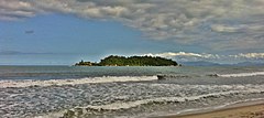
 View of the island in the background | |
| Geography | |
|---|---|
| Coordinates | 23°12′S 44°5′W |
| Highest elevation | 34 m (112 ft) |
| Administration | |
Brazil | |
| Southeast Region | |
| State of Rio de Janeiro | |
History
Records of the time indicate that in 1611, a Baiano (a man from the state of Bahia) would have been granted the island, at the tip of Iperuquara (possibly the one that separates Mambucaba from Praia Vermelha). Also recorded is an island of 200 fathoms in the same locality, granted to Estácio Ferreira in 1619 (possibly Ilha do Algodão).[2]
See also
References
- "Ilha do Algodão". Mapcarta. Retrieved October 20, 2019.
- "Um pouco da história… da Vila Histórica de Mambucaba". Vila Histórica de Mambucaba. Retrieved October 20, 2019. (in Portuguese)
External links
 Media related to Mambucaba at Wikimedia Commons
Текст в блоке "Читать" взят с сайта "Википедия" и доступен по лицензии Creative Commons Attribution-ShareAlike; в отдельных случаях могут действовать дополнительные условия.
Другой контент может иметь иную лицензию. Перед использованием материалов сайта WikiSort.org внимательно изучите правила лицензирования конкретных элементов наполнения сайта.
Другой контент может иметь иную лицензию. Перед использованием материалов сайта WikiSort.org внимательно изучите правила лицензирования конкретных элементов наполнения сайта.
2019-2025
WikiSort.org - проект по пересортировке и дополнению контента Википедии
WikiSort.org - проект по пересортировке и дополнению контента Википедии