geo.wikisort.org - Island
Iōtorishima or Iwo Tori-shima (Japanese 硫黄鳥島; Romaji: Iwo Torishima; Literal; "sulfur bird island"), or Okinawa Torishima ( 沖縄鳥島 ) is a volcanic island part of the Ryūkyū Island chain with the only[1] active volcano in Okinawa Prefecture.
Geography
Iotourishima is located 65 km west of Tokunoshima Island. On exceptionally clear days, Iōtorishima can be seen from the west coast of Tokunoshima.
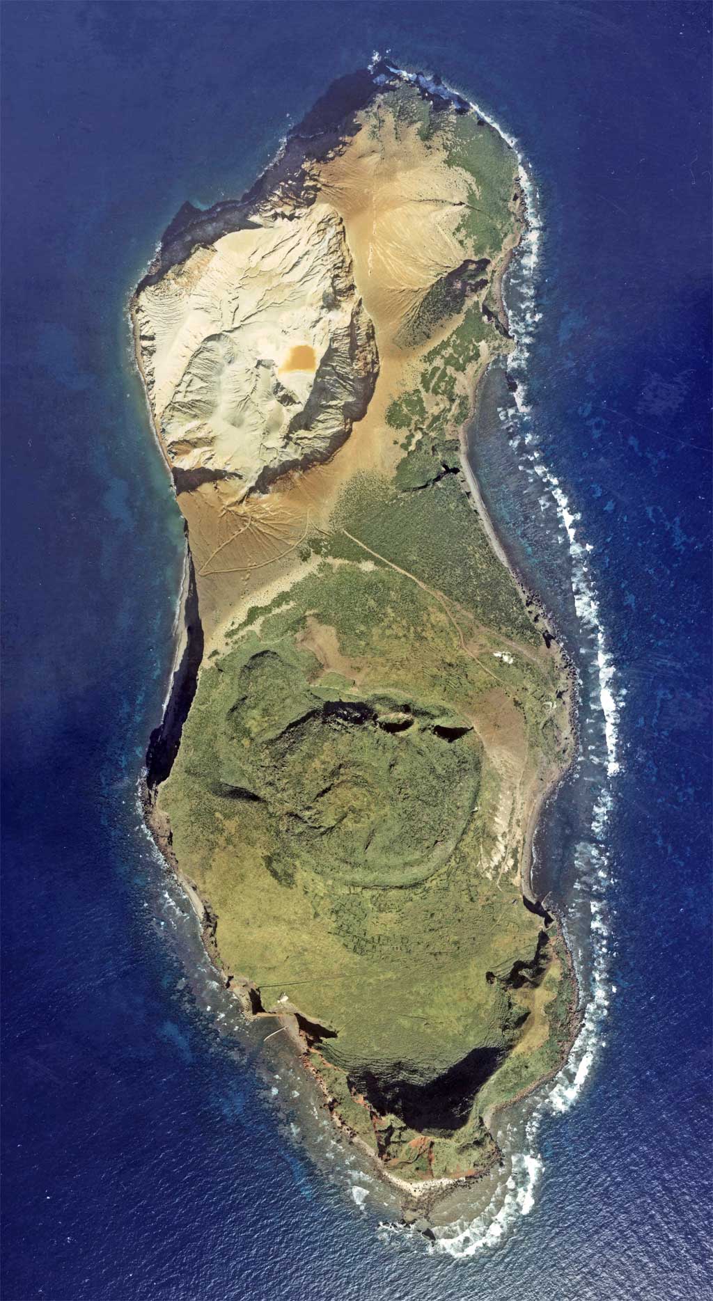
The 2.50 km²[2] large island consists of two interconnected volcanoes made from andesite. The southern Gusuku kazan ( グ ス ク 火山 , "Castle Volcano") is a lava dome located in the center of the two summits. The northern Iōdake-kazan ( 硫黄 岳 火山 , "Sulfur Peak Volcano") is a stratovolcano whose crater consists of a small lake of sulfur. It is still active, although none of the recent outbreaks had explosive character.[3][4] The highest point of the island is at 212 m, which belongs to Iōdake-kazan; the highest of the Gusuku kazan is the Maedake ( 前 嶽 ) at 189.3 m.[5]
History
Sulfur was mined by the inhabitants for centuries[1] within the Kingdom of Ryukyu, and it was used as tribute to the Chinese Empire.[6]
The first recorded eruption was in 1664, when a woman died from a landslide.[7] In a series of eruptions and earthquakes from March to August 1903, all residents were temporarily moved 220 km to Kume Island, but were permanently relocated by June 1958; the final settlement had 86 inhabitants. Since then, the island has been uninhabited. In July 1968 there was another eruption.
Administratively, the island belonged to Gushikawa on Kume-jima, but merged in 2002 with Nakazato to the city Kumejima.
See Also
- List of islands in Japan
- List of volcanoes in Japan
External links
Commons: Io-Torishima - Collection of pictures, videos and audio files relating to the island.
References
- "Creating a cadastral map of Iwo-Tori-shima". Ryukyu Shimpo - Okinawa, Japanese newspaper, local news. Retrieved 2019-02-07.
- "島しょ別面積/沖縄県". www.pref.okinawa.jp. Retrieved 2019-02-07.
- "Io-Torishima". Global Volcanism Program. Smithsonian Institution. Retrieved 2021-06-24.
- "硫黄鳥島|海域火山データベース|海上保安庁 海洋情報部". www1.kaiho.mlit.go.jp. Retrieved 2019-02-07.
- "地理院地図". maps.gsi.go.jp. Retrieved 2019-02-07.
- "Relocation of Tori Shima Range to Iwo-Tori-shima". Ryukyu Shimpo - Okinawa, Japanese newspaper, local news. Retrieved 2019-02-07.
- Information (NCEI), National Centers for Environmental. "Resource Removed | NCEI". www.ngdc.noaa.gov. Retrieved 2019-02-07.
На других языках
[de] Iōtorishima
Iōtorishima bzw. Iō-Torishima (japanisch 硫黄鳥島, veraltet: Iwo-Torishima, dt. „Schwefelvogelinsel“), auch Okinawa-Torishima (沖縄鳥島), ist eine Vulkaninsel der Ryūkyū-Inselkette mit dem einzigen[1] aktiven Vulkan der Präfektur Okinawa.- [en] Iōtorishima
Другой контент может иметь иную лицензию. Перед использованием материалов сайта WikiSort.org внимательно изучите правила лицензирования конкретных элементов наполнения сайта.
WikiSort.org - проект по пересортировке и дополнению контента Википедии