geo.wikisort.org - Island
Hua Islet[4][5] (Chinese: 花嶼; Hanyu Pinyin: Huā Yǔ; Tongyong Pinyin: Hua Yǔ; Pe̍h-ōe-jī: Hoe-sū; lit. 'flower islet[6]') is an islet in Huayu Village (花嶼村), Wangan Township, Penghu County (the Pescadores), Taiwan.[7] Hua Islet is the westernmost point in Penghu (the Pescadores).[3] The island has also been known as "West Islet" (西嶼).[8] The Japanese-built Huayu Lighthouse (Hua Islet Lighthouse[4]) is located on the southwestern hill of the island.[4][6]
Native name: 花嶼 | |
|---|---|
 Hua Islet (dark red) | |
| Geography | |
| Location | western Wangan Township, Penghu County (the Pescadores), Republic of China (Taiwan) |
| Coordinates | 23.403362°N 119.322301°E |
| Area | 1.2737 km2 (0.4918 sq mi)[1] |
| Administration | |
Republic of China (Taiwan) | |
| Province | Taiwan (streamlined) |
| County | Penghu |
| Rural Township | Wangan |
| Demographics | |
| Population | 339 (November 2017)[2][3] |
| Pop. density | 266.1537/km2 (689.3349/sq mi) |
| Additional information | |
| Time zone |
|

This article may be expanded with text translated from the corresponding article in Chinese. (August 2019) Click [show] for important translation instructions.
|
Ferries run periodically between Magong and Hua Islet as well as between Wangan Island and Hua Islet.[9][10]
History


Huayu Lighthouse (Hua Islet Lighthouse) was built in 1939 as part of Japanese military planning for the area.[11]
The handover of Taiwan to the Republic of China occurred in 1945. Huayu Village (花嶼村) was established in 1946.[3]
Residents on the island originally used a deep well for water. Over time, the well has dried up and a seawater desalination plant was built in 2019. On August 11, 2019, the desalination plant failed, leading to complaints from the residents. The plant was restored to normal operation by August 20.[12]
On the afternoon of October 5, 2019, an unnamed ship from China was caught violating Taiwanese waters 21 nmi (39 km) to the northwest of Hua Islet. The ship was boarded and the crew arrested.[13][14][15]
Geography
Hua Islet is the westernmost point in Penghu (the Pescadores), situated 18 km (11 mi) to the west-northwest of Wangan Island, 8 km (5.0 mi) to the north of the Mau Islets (Mao Islets; 貓嶼) and 8.5 km (5.3 mi) to the north of Cau Islet (Cao Islet; 草嶼).[3]
The island is shaped like a triangle. The highest point on the island is 53 m (174 ft) above sea level.[16]
The island is granitic making it geologically distinct from the other islands in Penghu (the Pescadores).[3]
See also
Gallery
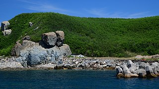 Couple Rock, in the Huayu harbor area.
 Huayu Lighthouse
 Mao islet (Cat islet), view taken from Huayu.
 The Rock of Guanyin statue.


References
- 澎湖的島嶼. 澎湖國家風景區管理處 (in Chinese (Taiwan)). Retrieved 2 November 2019.
# 行政區域 島嶼名稱 經度 緯度 面積 (平方公里) 有人居住 (*) {...}65 望安鄉 花嶼 119° 19' 20.14" 23° 24' 11.71" 1.2737 *
- 最新人口統計. 西嶼鄉戶政事務所 Xiyu Township Household Registration Office, Penghu County (in Chinese (Taiwan)). November 2017. Retrieved 2 November 2019.
2017年11月 各里人口數、戶數統計 村里 鄰數 戶數 男 女 人口總數{...}花嶼村 8 132 177 162 339
- 望安鄉 花嶼村. 澎湖縣望安鄉公所 Wangan Township Hall, Penghu County (in Chinese (Taiwan)). 10 August 2017. Retrieved 1 November 2019.
花嶼村位於花嶼,其位置在望安島西北稍南距離約18公里處,是澎湖縣最西方的島嶼,(也是台灣省的最西)。在花嶼正南方約距8公里為大、小貓嶼,正南方稍東約距8.5公里為草嶼。{...}光復後,民國35年,廢大字設村,稱花嶼村。{...}花嶼村位於澎湖縣望安鄉望安島西北稍南處,屬三級離島。該島地質有別於澎湖群島(玄武岩方山)而與金門島同為花崗岩層。{...}花嶼村目前居住人數僅約100餘人,
- "PENGHU From island to island" (PDF). Penghu County Government. 2010s. p. 2. Retrieved 1 November 2019.
Hua Islet Hua Islet Lighthouse Hua Islet Lighthouse
- Stephen Keeling and Brice Minnigh (2007). The Rough Guide to Taiwan. Rough Guides. London. p. 445 – via Internet Archive.
Hua Islet
{{cite book}}: CS1 maint: uses authors parameter (link) - "Huayu Lighthouse". Penghu National Scenic Area. Retrieved 1 November 2019.
since it is flourished with flowers and grass, a rare beautiful sight in Penghu, it was named "Huayu " (Hua meaning flower).{...}Huayu Lighthouse has also enjoyed the name of "Light of Huayu ", and is the main landmark of Huayu, built by the Japanese for military purpose.
- 澎湖縣土地段名代碼表 (in Chinese (Taiwan)). Department of Land Administration. 8 August 2000. Retrieved 1 November 2019.
地政事務所名稱(代碼) 澎湖(XA) 鄉鎮市區名稱(代碼) 望安鄉(05) 段 小段 代碼 備註{...}花嶼 0078
- 臺灣歷史地圖 增訂版 [Taiwan Historical Maps, Expanded and Revised Edition] (in Chinese (Taiwan)). Taipei: National Museum of Taiwan History. February 2018. p. 19. ISBN 978-986-05-5274-4.
福爾摩沙島與澎湖群島圖{...}L. 西嶼(花嶼)
- 交通船班. 澎湖縣望安鄉公所 Wangan Township Hall, Penghu County (in Chinese (Taiwan)). 7 October 2019. Retrieved 2 November 2019.
- 望安鄉車船管理所之107年11月24日交通船班時間表**馬公-花嶼**馬公-東吉-東嶼坪-西嶼坪**. 澎湖縣望安鄉公所 Wangan Township Hall, Penghu County (in Chinese (Taiwan)). 12 November 2018. Retrieved 2 November 2019.
- 花嶼燈塔 (in Chinese (Taiwan)). Maritime and Port Bureau. 11 May 2016. Retrieved 2 November 2019 – via YouTube.
基於軍事考量日人於昭和十四年一九三九年在花嶼的西北端建造了這座鋼筋凝土的白色圓塔花嶼燈塔
- 劉禹慶 (20 August 2019). 花嶼海淡廠停水逾10天 民眾怨搶修牛步. Liberty Times (in Chinese (Taiwan)). Retrieved 2 November 2019.
- 陸船撈過界 海巡佈陣逮船(內有影片). Penghu Daily (in Chinese (Taiwan)). 6 October 2019. Retrieved 2 November 2019.
- 張塵 (5 October 2019). 影/跪地求饒沒用!澎湖艦查扣無船名大陸漁船. Yahoo! News (in Chinese (Taiwan)). Retrieved 2 November 2019.
- 黃政義 (7 October 2019). 陸漁船撈過界 澎湖海巡查扣. Youth Daily News. Retrieved 2 November 2019.
- 花嶼燈塔. 澎湖國家風景區管理處 (in Chinese (Taiwan)). Retrieved 2 November 2019.
其中花嶼形如三角,最高處約53公尺,
External links
- 花嶼燈塔 ('Hua Islet Lighthouse') (in Chinese)
На других языках
- [en] Hua Islet
[fr] Îlot Hua
L'îlot Hua[1],[2] (Chinois traditionnel: 花嶼; pinyin: Huā Yǔ; Tongyong pinyin: Hua Yǔ; Pe̍h-ōe-jī: Hoe-sū; littéralement 'îlot des fleurs') est un îlot appartenant au village de Huayu (canton de Wang'an) dans le comté de Penghu à Taïwan. Il est le point le plus à l'ouest des Pescadores. L'îlot fut également nommé « îlot Ouest »; 西嶼). Le phare de Huayu, construit par le Japon, est situé sur une colline au sud-ouest de l'île[1],[3].Другой контент может иметь иную лицензию. Перед использованием материалов сайта WikiSort.org внимательно изучите правила лицензирования конкретных элементов наполнения сайта.
WikiSort.org - проект по пересортировке и дополнению контента Википедии